Monday, December 19, 2016

After the big chill, a nice break from the cold this week..

After a brutally cold weekend that saw temperatures drop to the minus 30C mark and windchills of -40 or lower, southern MB awoke to a different world this morning as temperatures soared into the minus single digits by 8 am.. a difference of +25C from 24 hours earlier. In Winnipeg, the temperature at 8 am was -4C, after being -30C at 8 am Sunday, the 18th greatest temperature rise within 24 hours in Winnipeg since 1953. Southwest winds ushered in a milder Pacific airmass over southern Manitoba overnight, flushing out the Arctic air that had been entrenched over the area since Dec 9th. And the good news is the above normal temperatures should continue the rest of the week, allowing for a pleasant lead up to the Christmas holidays. A couple of fast moving clipper systems will bring an occasional coating of snow (2-4 cm) both today and Wednesday, but overall, no major system are expected to impact southern Manitoba this week.  

Greatest temperature rises within 24 hrs in Winnipeg since 1953
Data courtesy of @jjcwpg


Potential winter storm for Christmas Day/Boxing Day?

The  benign weather pattern may come to end over the Christmas holiday weekend as long range models are indicating the potential for a strong winter storm to move across the northern Plain states and/or northern Minnesota by Christmas Day or Boxing Day. It's much too early to say if this storm will impact southern Manitoba and how badly, but there's growing consensus that a major storm system will be tracking across the northern Plains sometime over the Christmas/Boxing Day period. At this point, all we can say is to keep an eye on this potential winter storm that could be impacting holiday travel in southern MB (especially RRV and SE MB) depending on how it tracks. Realize however that models will be jumping around on the possible solutions on this storm system over the next few days until they get a clearer picture of where this storm will track. Stay tuned..

Wednesday, December 07, 2016

After the big dig, comes the big chill!

Residents of Winnipeg and southern Manitoba are digging out after a major winter storm brought heavy snow, high winds and blizzard conditions to much of the Red River valley Tuesday into Wednesday.  In Winnipeg, the storm dumped 25-35 cm of snow over the 2 days, with strong winds gusting to 70 km/h producing significant blowing and drifting snow. It was the city's worst winter storm in several years.. perhaps one of the worst since the blizzard of April 1997.  The storm was even worse outside the city as powerful winds of 70 to 80 km/h produced blizzard conditions over the western and southern RRV, leading to the closure of many highways including the TransCanada from Headingly to the SK border, Hwy 75 from Winnipeg to Emerson, as well as highways 2 and 3 southwest of the city. 

But now that the storm is ended, there's a new winter hazard to prepare for.. bitter cold. A massive Arctic airmass has settled in over western Canada, and this colder airmass will be be spreading into southern Manitoba over the next couple of days. By Friday, daytime highs are only expected to around -17C with lows in the minus 20s.  This will be the first time in 7 weeks that temperatures will be below normal in southern Manitoba. In Winnipeg for example, the average daily temperature has been above normal since Oct 21st, a streak of 48 straight days as of Dec 7th. This streak will come to an end Thursday as a new streak of below normal temperatures begins. Temperatures will remain well below normal through the weekend into next week, with even colder air moving in for mid week next week. Temperatures may dip to -30C or lower by Dec 14th, mid winter cold we haven't experienced since last winter.   So break out the parkas and get those block heaters ready..  much colder weather is on the way! 

Monday, December 05, 2016

Major winter blast heading for Winnipeg/RRV

HRRR forecast for 6 am Tuesday morning shows
strong winter storm affecting RRV/SE Manitoba 
The first major winter storm of the season is on its way into southern Manitoba as a low pressure system over eastern North Dakota slowly tracks towards the Canadian border. Heavy snow from this system is already affecting northeast North Dakota this evening, and will continue to spread north into southern Manitoba through tonight. Snow is expected to reach the Winnipeg area by 3-4 am overnight and become heavy by the Tuesday morning rush hour. In addition winds will be increasing from the north gusting to 60-70 km/h which will produce poor visibilities in blowing and drifting snow. Give yourself plenty of time to get to school or work tomorrow as road and traffic conditions will be poor. 

Snow will continue through Tuesday into Tuesday night, moderate to heavy times, with 15-20 cm possible by Tuesday evening. The evening commute will be slow and treacherous with double to triple commuting times. Winds will continue strong out of the north with gusts to 60 km/h in Winnipeg, with even higher gusts of 70-80 km/h possible over the western and southern Red River valley. These areas will be most susceptible to blizzard conditions given the strong winds and wide open terrain. Don't be surprised to see road closures on Highway 75 south of  Winnipeg, Highway 1 west of Winnipeg, and highways 2 and 3 southwest of the city. Snow is expected to continue Tuesday night with another 5 cm possible before the storm starts winding down on Wednesday, although blowing and drifting snow may continue to be a problem. All in all, a significant winter storm to usher in much colder weather for the end of the week. After being AWOL in November, winter is making a forceful return in December! Get ready!        

Saturday, December 03, 2016

Mild weather continues into early next week.. then Arctic plunge moves in! Significant snow possible Tuesday.

The above normal temperature pattern which has persisted over southern Manitoba for the past 6 weeks will continue through the weekend into early next week.. but a major pattern change next week will bring an end to the mild weather as a strong push of cold Arctic air floods across the Prairies from the west.  This will bring the first real cold weather of the season to southern Manitoba with temperatures in the minus teens and lows in the minus 20s by the end of the week.. a shocking change from the unusually mild weather we have been experiencing since late October (today will mark Winnipeg's 44th consecutive day above normal since the warm weather streak started Oct 21st). But first we'll have to deal with a minor system passing through southern Manitoba Saturday night into Sunday morning that will bring a couple cm of snow along the way. That will clear out by afternoon with a pleasant end to the weekend as temperatures remain well above normal for early December with highs around the freezing mark (normal highs are now -7C with lows of -16C!)
NAM model valid 3 am Tuesday morning shows potential storm
system over southern Manitoba with widespread snow
causing significant impact to the Tuesday morning commute
Stormy Tuesday?  Things start to get interesting Monday night into Tuesday as a storm system over Montana tracks towards the Red River valley, possibly bringing significant snowfall across southern Manitoba, including Winnipeg. Most models are suggesting that southern Manitoba could be seeing 10-20 cm of snow with this system as well as increasing northwest winds and falling temperatures on the backside of the storm Tuesday. One model however, the Canadian GDPS, is suggesting that the storm will mainly miss southern Manitoba before clipping southeast Manitoba Tuesday night into Wednesday. This solution could easily change over the next few days, so keep up to date on this potential storm system for southern MB that could have significant travel impacts Monday night into Tuesday. Regardless of what happens, be prepared for a big change to significantly colder weather by the middle of next week!     

Friday, December 02, 2016

A November to remember - warmest November on record in Winnipeg and much of Manitoba

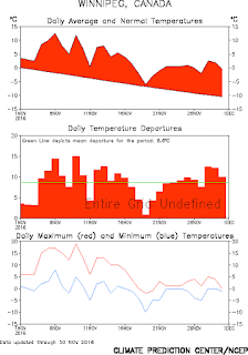
November 2016 will go down as the warmest November in 144 years of records in Winnipeg as a mild pattern that began at the end of October persisted right through the month. In Winnipeg, November ended up with an average monthly temperature of +3.1C, a whopping 8C above the monthly normal of -4.9C, easily beating the previous all time warmest Novembers of 1899 and 1923 at +1.3C. (Records for Winnipeg date back to 1872). Every day of the month was above normal, with an exceptionally mild first half that saw temperatures soar to a record high of 18.8C on Nov 9th.  The main story in November was the notable lack of cold, with only 5 days of the month seeing temperatures of -5C or colder, the fewest such days on record for a November (previous lowest was 7 days in Nov 1899)  Normally, November sees 20 days of -5C or lower, with an average low of -15C by Nov 30th!  The average low during Nov 2016 was an incredible -1.0C, which is just about the normal average HIGH for November (-0.6C)  The lack of cold weather resulted in a delayed start to winter, with the first measurable snow of the season falling on Nov 22nd.. the latest first measurable snow on record in Winnipeg (previous latest was Nov 21 1963) Although a blessing for many, the slow to start to winter was not welcome by all.. especially farmers trying to get work done on still soggy unfrozen fields, and ice fishermen.  For the first time in at least 55 years, there was no ice on Lake Winnipeg as of December 1st. This has caused a significant delay in the ice fishing season and those who rely on ice covered lakes to start winter fishing.

Mean monthly temperatures for November in Winnipeg 1872-2016
November 2016 was by far warmest in 144 year record 

Monthly temperature graph Nov 2016
Every day was above normal

Temperature anomaly map for Nov 2016 shows
core of anomalous warmth was over Manitoba


The list of records set in November in Winnipeg is impressive.  Among the notable milestones..
  • warmest November mean temperature (+3.1C, normal -4.9C)
  • warmest November mean daily maximum (+7.2C, normal -0.6C)
  • warmest November mean daily minimum  (-1.0C, normal -9.2C)  
  • most humid November (average dewpoint +0.3C, first time Nov avg over 0C)
  • 2 daily record high maximums (18.8C on Nov 9th, 13.6C on Nov 12th)
  • 3 record warm daily minimums (7.4 Nov 6, 4.8 Nov 9, 0.1 Nov 24
  • least number of days at or below -5C in Nov  (5 - previous low 7 in 1899)
  • least number of days below 0C in Nov (18 - previous low 20 in 2015)
  • latest date of first measurable snowfall of the season (Nov 22nd)  


The record warm November helped give Winnipeg its second warmest climatological fall on record (Sep 1 - Nov 30) with an average temperature of +8.0C, second only to 1963 (+8.6C) 


Average fall temperatures - Winnipeg (1872 - 2016)
graph credit @jjcwpg 
As of December 2nd, the mild weather pattern was persisting over southern Manitoba, with Winnipeg on its 43rd consecutive day above normal (a streak that started Oct 21st)  However, long range outlooks call for a pattern change to colder weather by the middle of next week.. putting an end to incredible 6 1/2 week run of above normal temperatures across southern MB.    

Tuesday, November 29, 2016

Finally looking like winter..

The storm system that brought a mix of snow and rain to much of the Red River valley Monday is now slowly tracking into Minnesota this morning, with colder air and snow wrapping around the system across southern Manitoba. Rain overnight changed to snow early this morning in Winnipeg, and will continue through the day with 4 to 8 cm possible by evening. Temperatures will hold steady near the freezing mark all day with northerly winds gusting to 50 km/h. Road conditions will once again be challenging, especially this morning.. so expect another SLOW commute today and give yourself plenty of time to reach your destination. Periods of snow will continue tonight with another 2 or 3 cm possible before snow tapers to flurries Wednesday.  Temperatures will gradually be cooling off over the next several days with highs below freezing.. so it looks like the covering of snow we get today into tomorrow will finally be sticking around for the winter. After the warmest November on record, it looks like winter is finally here!    

Tuesday, November 22, 2016

Late start to winter - Winnipeg posts latest date on record for first measurable snow of the season

After a record warm start to November, winter finally returned to southern Manitoba as the first measurable snow of the 2016-17 winter season fell across Winnipeg and southeast Manitoba today. Snow, mixed with ice pellets, began overnight creating a slippery and slow morning commute. About 3-5 cm of snow fell across the city by midday before it turned to a misty drizzle.  The snowfall marked the latest date on record for the first MEASURABLE snowfall of the season ("measurable" snowfall is defined as a snowfall of 0.2 cm or more)  The previous latest date of the first snowfall in Winnipeg was Nov 21 1963, set during the warmest fall on record (sidenote: President Kennedy was assassinated the next day in Dallas). Winnipeg snowfall records date back to 1872 (144 years of data)


Today's snowfall also marked the first time in 225 days that Winnipeg has had measurable snow (last recorded on April 10th when 0.4 cm fell). The 225 days is Winnipeg's 3rd longest snowless streak on record, behind only 1998 (232 days) and 1900 (228 days)  Average snowfree period in Winnipeg is 181 days, which means Winnipeg enjoyed 6 more weeks of snowfree weather this year compared to average.

Saturday, November 19, 2016

Major winter storm bypasses Manitoba.. Winnipeg still waiting for first measurable snow. Next threat for snow Monday night into Tuesday


The first major winter storm of the season blasted
Minnesota and NW Ontario Friday with
blizzard like conditions, but spared Manitoba
(photo along I-94 in Minnesota)
A Colorado low winter storm system tracked across Iowa into southern Minnesota Friday bringing a blast of wintery weather across much of northern and western Minnesota. The storm dropped 20-40 cm of snow across northern Minnesota with up to 60 cm (24 inches) reported near Orr in the far north. The storm also produced strong northerly winds which resulted in blizzard like conditions across much of the western state leading to numerous traffic accidents and some road closures. As the storm moved north, heavy snow pushed into NW Ontario mainly east of Dryden with 30-40 cm reported in Atikokan and Upsala, and 10-25 cm in Thunder Bay. Earlier in the week, models were suggesting this storm could be taking aim at southern Manitoba, but the storm took a track further south and east sparing Manitoba from any major impact. We did however get colder weather on the backside of the storm with northerly winds producing bands of lake effect flurries off Lakes Winnipeg and Manitoba. After a record mild start to November with well above normal temperatures over the first half of the month, temperatures will be closer to normal over the next few days.

When's it going to snow here? 

So after missing this big storm Friday, and missing several snowfalls in October which affected Saskatchewan and Alberta, Winnipeg and much of the RRV are still awaiting their first measurable snowfall of the season. As of today (Nov 18th), Winnipeg has gone 222 straight days without measurable snow, the 4th longest such streak on record here (see table below). Our last measurable snow in the spring was 0.4 cm on April 10th (we had some snowflurries on May 13th, as well as Oct 7th and Nov 2nd, but no measurable accumulation on those days, just a "trace")    

Top snowless streaks in Winnipeg as of Nov 15
records since 1872 (chart courtesy of @jjcwpg)


Next threat for widespread snow across southern MB
will be overnight Monday into Tuesday 

(NAM model valid 6 am Tue morning Nov 22) 

Barring any measurable snow from lake effect flurries tonight into Saturday morning (some areas east and west of Winnipeg are getting some accumulating snow off Lakes Winnipeg and Manitoba), the next threat of snow over southern MB will be Monday night into Tuesday as a low pressure system in Saskatchewan moves east, spreading an area of snow into Manitoba. This will not be a major winter storm like the one that hit Minnesota today, but it may result in our first measurable snow here in Winnipeg and the RRV, with perhaps 2-5 cm by the Tuesday morning commute.      
 

Sunday, November 13, 2016

Record warm start to November.. but reality check by late week as potential winter storm looms for southern Manitoba

It's been an exceptionally warm November so far across southern MB and much of the Prairies. For Winnipeg, the first 10 days of November this year have been the warmest such period in over 140 years of records. Simply put, Winnipeg has never had a warmer start to November since records began in 1872.  Temperatures in Winnipeg so far are averaging a phenomenal 8.5C above normal since Nov 1st, with an average of +6.6C through Nov 13th (normal is -2C for this period)  That is more typical of mid October than mid November!  9 of the first 13 days this month have hit double digits, with a record 18.8C on Nov 9th, the latest date on record that the city has hit 18C or more.  Daily minimums have been mild as well with lows generally staying above freezing, and only 2 days below -2C.  The weather has been so unusually mild, grass is still green in the city and there are reports of flowers reblooming in parts of southern MB.  An exceptionally low snowpack across Canada so far this year together with record low Arctic sea ice has kept Arctic airmasses from intensifying across the north and pushing south. In addition, strong Pacific storms over the Gulf of Alaska have spread persistent warmth across southern Canada over the past 2 weeks, effectively blocking any incursion of cold air southward.  


Charts showing temperatures past 30 days in Winnipeg (left)
and temperature anomaly map over the US this November (right)
Note greatest anomaly core (> +8C) over southern MB 


Chart showing warmest starts to November in Winnipeg since 1872

UPDATE: Winnipeg records warmest first half of November in over 140 years 


It's official.. Winnipeg has never seen a warmer first half of November than this year. Over the first 15 days of the month, the average temperature in Winnipeg has been +6.3C, easily the warmest first half of November here since records began 144 years ago in 1872.  It beat out the previous warmest start to November in 1981 and 1931 by almost 1.5C, a large margin for long term climate records. The average of +6.3C was more typical of mid October here, and was an astounding 9C above the average temperature of -2.6C which is normally expected over the first half of November in Winnipeg.  Truly a historically warm start to November.  

Late week winter storm looms.. 

GFS outlook for Friday evening Nov 18th showing
major winter storm possible for southern MB
 
But this is the Prairies and it's mid November. The abnormal warmth has to come to an end at some point, and long range models are indicating that the transition to winter may be coming to southern Manitoba by the end of the week as a strong storm system tracks across the northern Plain states. There is still considerable uncertainty on the path of this storm and its possible impacts to southern Manitoba, but the potential is there for a significant winter storm to affect portions of southern Manitoba late in the week, especially over the Red River valley and southeast Manitoba. This system may bring the first major winter storm to parts of southern Manitoba on Friday Nov 18th-Sat Nov 19th with heavy snow, strong winds and possible blizzard conditions. This system is still 5 days out and details such as storm track, intensity and precipitation distribution need to be refined in the days ahead as models get a a better handle on this storm. In the meantime, enjoy the next few days of continued mild weather and prepare for a sobering reality check to winter by the end of the week.     

GEPS ensemble 24 hr precipitation outlook valid Sat morning Nov 19th
Highest threat for heaviest precip over southern MB is over SE areas  

Thursday, November 03, 2016

Unseasonably mild start to November for southern MB.. double digit highs possible through Remembrance Day

November is off to a mild start as a large upper ridge of high pressure takes hold over mid-continent, bringing an extended spell of above normal temperatures across the Prairies. Temperatures have soared into the mid to upper teens over North Dakota, southern SK and Alberta, with even some 20C temperatures in southern Alberta (21C in Pollockville, 20C in Drumheller)  The mild weather will push into southern Manitoba over the next day or so as a warm front slowly moves north. This front was accompanied by extensive low cloud and fog today over southern Manitoba, which was slow to clear as increasing temperatures aloft produced a strengthening inversion that trapped the low level moisture much of the day. Gradually, this low cloud and patchy fog is expected to push north and clear during the night low as level southerly winds increase this evening. Note however, winds are expected to decrease overnight which may lead to additional low cloud and fog development in some areas early Friday. Friday should be a nicer day with morning cloud and fog patches giving way to a mix of sun and cloud, and highs finally reaching the double digits across much of southern MB. The nice conditions are expected to continue into the weekend with highs in the mid teens, possibly upper teens along the Pembina escarpment. A disturbance tracking up through the Dakota may bring some light showers Sunday night into Monday, but they shouldn't amount to much with a few mm possible. Mild weather should continue through next week with highs at or above the 10C mark through Remembrance Day, and nighttime temperatures at or above freezing. Note that the longest stretch of highs at or above 10C in Winnipeg in November is 8 days from Nov 2-9 1963. There's a possibility that Winnipeg could be challenging that record. Otherwise, enjoy the October like start to November!          

Friday, October 28, 2016

Soggy Halloween on tap.. otherwise staying mild through first part of November

 Milder than normal weather is expected to continue over southern Manitoba through the first part of November, with no real signs of winter weather just yet. Temperatures are expected to range some 5-10C above normal for early November with highs of 8-15C through the first week (normal highs for November in Winnipeg drop from +5C on Nov 1st to +1C on Nov 10th) In particular, Thursday Nov 3rd is looking very mild with highs of 15C possible for Winnipeg and southern MB.


Generally dry weather is expected through the period, with the exception of one day.. unfortunately falling on Halloween. A low pressure system is forecast to track across North Dakota next Monday Oct 31st spreading an area of rain across southern MB. This system could bring 10-25 mm over portions of the Red River valley likely starting Monday morning and continuing in the evening before tapering off by midnight. Temperatures will be around +7C Halloween evening.. so conditions will be relatively mild, but wet.        


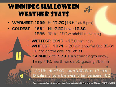
UPDATE: Winnipeg airport recorded 15.8 mm of rain on Oct 31st, making it the city's rainiest Oct 31st on record. The previous rainfall record for Oct 31 was 11.6 mm in 2000. Another 1.7 mm fell early this morning for a storm total of 17.5 mm. Rainfalls of 15 mm or more become less frequent in Winnipeg as we get into November, especially after the first week (see Nov precip records for Winnipeg). But they have occurred as late as December with 21.8 mm on Dec 2nd 1982, and an unusual 15.2 mm on Dec 22 1877 (during the freakishly warmest December on record in Winnipeg)   The rainiest November day in Winnipeg was on Nov 17 1918 when an astounding 44.5 mm of rain fell, with 50.9 mm over the 2 day span of Nov 16-17.   

WINNIPEG HALLOWEEN WEATHER STATS


Wednesday, September 28, 2016

Beautiful fall weather to close out September and begin October. Unsettled weather returns next week with colder conditions by Thanksgiving weekend

Lovely fall weather will finally prevail over Winnipeg and the RRV over the next few days as a sprawling high pressure ridge brings sunny and milder weather into southern Manitoba. Today will see plenty of sunshine and light winds.. a pleasant change from the cloudy, cool and blustery conditions over the last couple of days.  And the good news is that this pleasant fall weather is expected to continue through the weekend into early next week with generally sunny skies, and above normal temperatures near the 20C mark. Unfortunately, it looks like the ideal weather will be giving way to more unsettled conditions next week, as a strong low pressure system organizes in the western US and tracks towards southern Manitoba. This system will likely bring rain back into our area next Tuesday through Thursday, with much cooler conditions expected by late week into Thanksgiving weekend behind the system. In fact, model guidance is suggesting highs only in the single digits over Thanksgiving weekend with a killing frost possible.            

Thursday, September 01, 2016

Summery start to September to give way to cooler wetter conditions over Labour Day weekend

September is off to a beautiful start over southern Manitoba with sunshine, balmy breezes and summerlike temperatures in the upper 20s (and even low 30s over western MB)  Friday will see another warm summerlike day, although winds will be quite gusty, especially in the Red River valley (including Winnipeg) where southerly winds gusting to 60 -70 km/h are expected by afternoon. Not the best bike riding weather if you're heading south!  Friday night, a weak front will push through southern Manitoba with a small chance of thunderstorms, leading to partly sunny skies Saturday and temperatures in the mid 20s. Clouds are expected to increase Saturday afternoon with a few showers likely by evening as a cold front pushes through. Sunday looks cooler and unsettled at this point as a low pressure system over the Dakotas rides up along the cold front and spreads an area of steady rain over much of southern Manitoba by the afternoon into the evening. This could be quite a soaking rainfall for many areas, with rainfall amounts of 20-40 mm possible Sunday afternoon into Monday morning. Rainfall should ease off Monday morning leaving cloudy and cool conditions Labour day Monday.  The rest of the week looks generally cooler than normal with temperatures in the upper teens.. a taste of fall as the kids head back to school! 

Wednesday, July 13, 2016

Cool wet weather to give way to drier warmer conditions by weekend into next week

Departure from normal precip (mm) across Prairies since
Apr 1st. It's been notably wet across the far south
The frustrating weather pattern that has plagued southern Manitoba with frequent precipitation events over the past 6-7 weeks continues to linger into mid July with yet more rain today. A large storm system tracking through northern Manitoba will bring cool, windy and unsettled conditions throughout southern Manitoba today, making it seem more like a day in mid September than mid July. But once this system finally starts to move eastward tomorrow, a gradual improving trend is expected later this week through the weekend and possibly through much of next week with a warmer and drier pattern setting up. Long range models are indicating the development of a massive dome of hot and stable air that will be setting up over the central US plain states next week, that hopefully will edge northward into southern Manitoba. The core of the heat will be south of the international border over states like Iowa, Nebraska and South Dakota where temperatures of 35-40C are likely in what will be an extended heat wave next week. Some traditionally hotter spots there may be seeing temperatures as high as 43C (110F)  In Manitoba, temperatures will likely be above normal with temperatures of 25-30C expected with a trend towards less frequent shower and thunderstorm activity. However, given that southern Manitoba is expected to be lying on the northern edge of the heat dome, there will likely be periodic thunderstorm activity as impulses round the upper ridge (aka "ridge riders")  One potential type of severe weather threat with this type of upper pattern is the "derecho" - a cluster of powerful long lived thunderstorms that ride along the periphery of the upper ridge and produce widespread wind damage along its path, often at night.   

 Large upper ridge expected to dominate weather pattern over central US next week bringing widespread heat over much of the US edging into southern Canada 

A pattern change to drier and warmer weather is desperately needed over southern Manitoba. After a dry start to the growing season, the overall pattern turned wetter and more unsettled in late May and has persisted through much of June through the first half of July. Some places in the Red River valley have seen over 2 times the normal precipitation since June 1st. Lettelier for example has recorded a whopping 313 mm of rain from June 1st to July 12th, some 260% of normal. Since May 23rd, Winnipeg (and much of southern MB) has had only one stretch of 4 or more days with no measurable rain (June 13-16) otherwise, rain has been occurring every other day or two over the past 6 weeks, often heavy at times. Farmers are hoping that drier and warmer weather will salvage what could be a very good crop this year.


Monday, June 06, 2016

The week ahead.. cool start with a hot and stormy finish

The weather in southern Manitoba this week will see a transition from a cool fall-like start to a more summerlike pattern by the end of the week, complete with increasing heat and humidity as well as the risk of potentially severe thunderstorms by Thursday or Friday.  Highs today will only top out around 19C, some 5C below normal for early June, but by Friday, Winnipeg and the RRV could be looking at temperatures close to 30C. The increasing heat and humidity along with a couple of weather systems tracking across southern Manitoba will lead to the development of scattered thunderstorms, some of which may be severe. Stay tuned through the week as this developing weather situation evolves.   

Sunday, May 29, 2016

A brief dry period.. then another round of showers and thunderstorms on the way Monday night into Wednesday. Areas of heavy rainfall likely especially over southwest Manitoba

It's been a wet week over much of southern Manitoba this past week. Since last Sunday (May 22) general rainfall amounts of 40-70 mm have fallen across much of southern Manitoba, with locally heavier amounts in some places. (I've recorded 70 mm at my site in SW Winnipeg since last Sunday night)  Today saw a welcome break from the unsettled weather with partly sunny skies this afternoon, and we'll enjoy rainfree weather much of Monday before another bout of wet weather moves into southern Manitoba.  The culprit this time will be a developing low pressure system over North Dakota which will spread showers and thunderstorms over southwest Manitoba later Monday into Monday night, moving into the Red River valley Monday night into Tuesday.  The heaviest rain is expected Monday night into Tuesday morning.

Projected rainfall totals (inches) Mon-Wed. Heaviest
rainfall expected over SW MB with 75 mm possible
Rainfall from this system will be highly variable since localized areas will see heavier amounts from slow moving or persistent heavier shower or thunderstorm cells. Places which miss the heaviest convection will see lower amounts. In general, most places in southern Manitoba will likely see 20-30 mm of rain Monday night into Wednesday morning, with heavier totals of 50-75 mm possible in some areas.. especially over the southwest corner of the province (Melita, Virden, etc) where current guidance is indicating the greatest probability of heaviest rainfall.  At this point, one should focus on the potential for heavy rain over the next few days instead of the exact location.. which will likely change slightly as models try to predict the track and intensity of this system.


Sunday, May 15, 2016

After a chilly weekend.. things looking up this week.

It was a chilly weekend over southern Manitoba with high temperatures only near 11C Saturday, and 15C today along with some showers.  But the rest of the week is looking up as the cool airmass moves east and a warmer upper pattern re-establishes itself over the Prairies.  The result will be a warmer and drier week coming up with ample sunshine and highs back to the 20C mark by Tuesday, and mid to upper 20s by the end of the week.  The early outlook for the Victoria Day long weekend looks warm and increasingly humid with a chance of showers and thunderstorms by Monday.  

Monday, May 09, 2016

Warm start to week with a cold finish.. and some rain in between..

It's been a summery and dry start to May in southern Manitoba with plenty of sunshine and warm temperatures. As of Sunday May 8, the monthly mean temperature for the month has been 14C in Winnipeg, about 3-4C above normal for the first week of May.  And the warm weather is expected to continue Monday with another sunny but hazy, breezy and dry day, and highs of 25C.  But that will be the end of the warm weather for awhile as the upper weather pattern shifts this week to bring cooler and more unsettled weather into southern Manitoba.  Tuesday will see a band of showers sweep across southern Manitoba ahead of a deepening storm system over Montana and Dakotas.  Scattered showers are expected Wednesday as the storm system slowly tracks across southern Manitoba, before cooler weather arrives Thursday behind the system with northwest winds and occasional rain keeping temperatures only near 10C.  The rain should pull off Friday, but temperatures will be quite chilly with highs only in the single digits of +5-8C, quite a contrast to the how the week started in the mid 20s.

But we can use the rain. Today marked the 3rd straight week with little or no rainfall in Winnipeg and much of southern MB. Preliminary guidance is indicating that 10-20 mm of rain is possible between Tuesday and Thursday across Winnipeg and the RRV. And at this point, not too many people will be complaining considering how dry things have been. In fact the dry weather has led to a couple of large wildfires near the Ontario/Manitoba border over the past few days, and Monday will see high risk fire weather conditions with gusty southeast winds, warm temperatures and low humidity.  

Friday, April 29, 2016

Beautiful weekend ahead.. dry weather to continue for the next week

Finally! A beautiful weekend to enjoy in southern Manitoba. Weekends in April have not been kind to Monday-Friday workers, with below normal temperatures and a washout weekend in mid April. But this weekend looks terrific to enjoy the outdoors and get that BBQ going.. plenty of sun and temperatures in the mid to upper teens, slightly above normal for the end of April (normal highs 15C).  And the good news is the dry weather should continue much of next week, with no major systems expected to impact southern Manitoba through next Friday. In addition, temperatures will be climbing into the mid 20s by the end of week, although there may be a brief cooldown mid week. The next threat of any meaningful rainfall over southern Manitoba looks to be over the weekend of May 7-8th as a storm system tracks across the Dakotas with showers and possible thunderstorms. It's still a week ahead though, and there's still considerable uncertainty on the track of this system and what impacts it will have on southern Manitoba. In the meantime.. enjoy the lovely dry weather!

Saturday, April 23, 2016

Seasonably cool but dry week ahead.. stormier and wetter south of US border

Forecast precipitation Apr 23 - 30th (inches) shows dry
conditions over Manitoba but wet south of the US border
(image from NOAA -WPC)  
The last week of April is looking mainly rain-free across most of southern Manitoba as a blocking ridge of high pressure over northern Manitoba maintains cool but dry conditions across the province. Temperatures over southern Manitoba will be in the 10-13C range Sunday through Thursday.. which is just slightly below normal late April highs (14C)  But while we remain dry in southern Manitoba, it will be a different story south of the US border as a couple of strong storm system track across the central plains over the next few days.  On Sunday, a storm system will track across South Dakota spreading showers across North Dakota and northern Minnesota, with locally heavy rain possible.  The pressure gradient between high pressure over northern Manitoba and low pressure over South Dakota will result in a brisk easterly flow across southern Manitoba Sunday, with east to northeast winds of 40 gusting 60 km/h expected. Those winds will add a bit of a chill to an otherwise fairly nice day Sunday.

Severe weather risk map for Tuesday April 26th
shows severe storms possible through southern plains
(Weather Network graphic)  
Tuesday will see another storm system tracking a bit further south, across western Kansas, bringing a severe weather threat across the US "tornado alley" from northern Texas through Oklahoma into Kansas. In fact, the US Storm Prediction Center (SPC) in Norman OK has already warned of a potential outbreak of severe storms Tuesday with violent tornadoes and large hail possible. Stay tuned on this developing system for early next week. The system will also spread additional rain across much of South Dakota, some of it locally heavy. The system is expected to push east into the Ohio Valley by mid week with high pressure continuing to dominate over Manitoba. The result will be a dry week here with seasonably cool temperatures gradually warming to normal or above normal values by the end of the week.  Overall, it looks like parts of North Dakota, Minnesota and South Dakota could see 25-50 mm of additional rainfall over the upcoming week.    

Tuesday, April 19, 2016

A couple nice days.. then back below normal. April stuck in neutral here while western Canada bakes..

After a miserably wet and cool weekend that saw 30 to 50 mm of rain dumped on the Red River valley,  drier weather has returned to southern Manitoba this week with sunshine and temperatures above seasonal values. And it looks like we'll see one more warm day Wednesday before yet another change to cooler weather by Thursday which is expected to persist through the weekend into early next week.  Wednesday should see sunshine mixing with clouds and temperatures near 20C in the afternoon with a southwest breeze. A cold front however will slide through southern Manitoba from the north Wednesday evening/night bringing a drop in temperatures for Thursday.  Highs Thursday will struggle to reach 10C, some 10 degrees cooler than Wednesday's highs.    

On Friday, a weak system will track across southern Manitoba from the west bringing an area of light rain, possibly mixed with, uggh, wet snow Friday morning over western Manitoba. (Current forecasts of "sunny" weather Friday for the Red River valley are way too optimistic based on current model guidance. Don't be surprised to see that forecast change over the next day or two)

The weekend looks generally dry but cool as high pressure over northern Manitoba maintains a northeast flow of dry cool air across southern Manitoba. A developing storm system over the central US plains states threatens to bring some rain across southern Manitoba early next week but most guidance is suggesting this  area of precipitation will stay mainly south of the international border.  If so, that would mean generally dry weather next week along with near normal temperatures.  Sustained warmth however still appears to be delayed in arriving here as the upper flow keeps bringing spells of below normal temperatures over central and eastern Canada.                

Fire risk across Canada shows extreme
fire danger across western Canada (CBC image)
Meanwhile, it's a different story over western Canada which has been experiencing an exceptionally warm and dry spring after a warm dry winter. Yesterday saw over two dozen record highs set in Alberta including 26C in Edmonton, and a sizzling 29.4C in Grand Prairie which tied its all time April maximum set back in 1977.  Conditions have been extremely dry out west thanks to a persistent upper ridge over western North America. Calgary for example has seen only 0.6 mm precipitation this month, just 4% of normal and only 7.4 mm since Feb 1st (17% of normal). The dry conditions have led to an extreme fire risk across much of the province as well as parts of Saskatchewan. Hopefully, they get some much needed rain over the next few weeks otherwise forest and grass fires will become an increasing threat over the west.    

Sunday, April 17, 2016

Significant rains hit southern Manitoba

From Environment Canada:

Several waves of precipitation moving along a slow moving frontal 
system over the North Dakota/Minnesota border has resulted in 
significant precipitation amounts over southern Manitoba since 
Friday. In general, about 25-50 mm of rain has fallen across much of 
southern Manitoba from Friday through Sunday, with even some 
accumulating snow reported over southwestern Manitoba into the 
Riding Mountain area. 

The following are rainfall totals since midnight Friday up to 7 pm 
Sunday evening. Data is from Environment Canada and Manitoba 
agriculture weather stations. Rain continues this evening over the 
southern Red River valley and southeast Manitoba where an additional 
5 to 10 mm of rain is possible tonight. Elsewhere, no additional 
rainfall is expected. Rainfall amounts in millimeters (mm) 

Winnipeg Airport: 38 mm 
Winnipeg Forks: 42 mm 

Deerwood (Miami): 49 mm 
Selkirk: 47 mm 
Arborg: 44 mm 
Carman: 43 mm 
Gladstone: 43 mm 
Manitou: 43 mm 
Gimli: 43 mm 
Great Falls: 43 mm 
Beausejour: 42 mm 
McCreary: 40 mm (mixed with snow) 
Portage La Prairie: 40 mm 
Pinawa: 37 mm 
Inwood: 37 mm 
Pilot Mound: 35 mm 
Fisher Branch: 35 mm 
Morden: 32 mm 
Deloraine: 31 mm (mixed with snow) 
Killarney: 30 mm 
Wasagaming: 30 mm (mixed with snow) 
Dauphin: 29 mm (mixed with snow) 
Emerson: 28 mm 
Gretna: 28 mm 
Kleefeld: 26 mm 
Brandon: 25 mm (mixed with snow) 
Steinbach: 21 mm 
Morris: 19 mm 
Virden: 17 mm (mixed with snow) 
Sprague: 14 mm 

Precipitation fell as snow over parts of southwest Manitoba into the 
Riding Mountain Park area Saturday into early Sunday. Some snowfall 
reports are as follows: Snowfall amounts in centimeters (cm) 

McCreary: 9 cm 
Neepawa: 9 cm 
Wasagaming: 7 cm 
Oak River: 7 cm 
Rivers: 6 cm 
Waldersee: 6 cm (southeast of McCreary) 
Oak Lake: 5 cm 
Melita: 5 cm 
Souris: 2-5 cm (estimated) 
Boissevain: 4 cm 
Virden: 4 cm 
Brandon: 2 cm 
Austin: Trace

Monday, April 11, 2016

Warmer weather on the way this week.. but increasingly wet by late week

Warmer weather is finally on the way over southern Manitoba this week, but it looks like it will be getting progressively wetter later in the week as well. Significant rainfall is possible in some areas (possibly 25-50 mm) especially over SW Manitoba and the Interlake regions where cooler temperatures will prevail as well.  The details:

After a clear and cold night tonight, Tuesday will see increasing clouds and increasing southerly winds as well. Temperatures will begin climbing closer to normal values with afternoon highs near +6C in Winnipeg, but cloud cover and brisk southerly winds will make it feel cooler. Wednesday is looking like the nicest day of the week as we get into more sunshine and lighter winds, and temperatures into the low teens for the first time this month. On Thursday, a warm front pushing up from North Dakota will start spreading clouds and some scattered showers across southern MB, with increasing humidity and temperatures in the teens.

Friday will see a battle zone setting up over southern MB with
warm humid air to the south and cool air to the north. Areas of
heavy rain are expected along and north of the frontal zone
Things get even more interesting by Friday. On Friday, the warm front over North Dakota will push into southern Manitoba and stall somewhere from Pilot Mound through Winnipeg into the Pinawa area. This front will mark a battle zone across southern MB, delineating warm springlike conditions over the southern RRV and SE MB (where 20C temperatures are possible), from much wetter and cooler conditions north of the front (significant rain over SW MB into the interlake along with temperatures in the single digits). For Winnipeg and areas near the frontal boundary, the location of this front will have a major impact on temperatures and precipitation chances. If the front is north of Winnipeg, we'll see warmer temperatures and less rain. If the front is south of us, look for cooler temperatures and more rain. Models have been flip flopping on whether or not this front makes it north of Winnipeg but we're only talking about a few miles that can make a big difference. We'll keep you posted on how models trend with the position of this front as the week goes on. Suffice to say, Friday will see some significant rain across portions of southern MB (possibly even some embedded thunderstorms) while other areas (especially south and east of Winnipeg) see warmer temperatures possibly near 20C.  The unsettled weather will push across southern Manitoba Saturday with more showers, followed by drier and cooler conditions Sunday.   

Friday, April 08, 2016

Windy, cool, unsettled weekend.. then FINALLY!.. pattern change to warmer weather beginning next week

500 mb pattern so far in April has featured a stubborn
Arctic vortex and trof over Hudson Bay into Great Lakes
It's been a cold start to April across much of central and eastern North America with a persistent pattern of below normal temperatures and occasional snowfall since the beginning of the month. A stubborn Arctic vortex and long wave trof digging unseasonably deep into the eastern US has been responsible for the winter like start to April over southern MB and Ontario, while the western Prairies and west coast have basked under above normal warmth.  This pattern will remain in place over the weekend as another clipper system tracks through southern MB and reinforces cool air behind it, but there are finally signs that this stubborn pattern will be changing by the middle to end of next week bringing more seasonable, and even above seasonable temperatures to southern MB.

Surface prog valid Saturday evening shows next
clipper system tracking through interlake region
But first, we have to get through this weekend which will feature another clipper system tracking through southern MB bringing strong southerly winds and a chance of snow ahead of it on Saturday, some rain or snow Saturday night, then blustery and cool conditions Sunday. Model guidance is indicating this clipper system will track north of Winnipeg through the Interlake region this weekend, bringing heavier snow accumulations of 10 cm or more through the northern Interlake and central MB. Further south, Winnipeg/RRV will see a band of light snow moving through ahead of the system Saturday morning along with strong south to southeast winds gusting to 70 km/h by midday and afternoon. Temperatures will only struggle to +4C or so, still below normal for this time of year (normal highs now +8C) and feeling even cooler with those strong winds. As the clipper system tracks through the interlake Saturday night, scattered rain or snow showers are expected over southern MB with steadier snow through the northern interlake regions. On Sunday, blustery NW winds will bring in a reinforcing shot of below normal temperatures again over southern MB along with occasional flurries or snow, and afternoon temperatures only around +2C or so.

CPC outlook for Apr 14 -19 finally gives hope for
a return to warmer weather over southern MB
The good news is that this weekend storm system should finally be the last of the clipper systems for a while with a trend to warmer and more settled conditions next week. Below normal temperatures but dry conditions are expected over southern MB for Monday and Tuesday, but then a long awaited pattern change is expected to bring in warmer air by Wednesday with near seasonal temperatures, and even above normal temperatures in the mid to upper teens possible by the end of the week into next weekend.  So hang in there folks... warmer weather is on the way!

Thursday, March 31, 2016

Cold start to April with occasional bouts of snow

The mild conditions that finished March will unfortunately not be continuing into the start of April as a spell of colder than normal weather pushes into southern Manitoba. A cold front tracking through southern Manitoba today is bringing a northerly flow of colder into the province, along with a coating of snow over western Manitoba (up to 10 cm northwest of Brandon early this morning).  On Friday, a clipper system is forecast to dive across southern Manitoba by the afternoon, bringing occasional snow to the RRV in the afternoon and evening, with a coating to 3 cm possible. This will be followed by a cold Saturday with highs remaining below freezing (normal highs for early April are +5C)  On Saturday night, another fast moving clipper will spread an area of light snow across southern Manitoba, with again, a coating to 3 cm possible Saturday night into Sunday morning. Monday looks quiet and cold before a stronger clipper system threatens rain and wet snow Tuesday into Tuesday night. Below normal temperatures are expected Wednesday and Thursday behind the system before a more general warmup by the end of the week into next weekend. 

Friday, March 25, 2016

The week ahead: Generally mild and pleasant before possible mid week storm system. Long range models indicating unseasonably cold start to April

Weather highlights for upcoming week... (Fri March 25 to Fri April 1st)

Cold night ahead! Clear and cold tonight with lows dropping to -15C in Winnipeg by early Saturday morning.. possibly some -20C readings north of the city.

Nice Saturday.. After a chilly start, ample sunshine will boost temperatures up to 0C by afternoon with light winds in the morning becoming south 20 km/h in the afternoon.

Saturday night into early Sunday.. weak system passing through southern Manitoba may bring a dusting of snow to Winnipeg and the RRV.

Easter Sunday: Nice day. Early flurries giving way to sunshine. Afternoon highs of +5C.

Monday, Tuesday: Dry and mild. Highs of +7 to +10C.

Wednesday Mar 30: Storm system tracking through the Dakotas will bring an area of rain and snow across the Dakotas, possibly spreading into southern Manitoba. At this point, it appears bulk of precip will be over North Dakota, however some models (like the GFS) are bringing more significant precipitation into southern Manitoba, with possible snow accumulations. Will need to watch this system closely and see if models trend further north.

Thursday: Dry and seasonable: Highs near +5C (however, temperatures will be cooler if we get snow from Wednesday system)

Friday April 1: Mother Nature is gearing up for one of her cruel April fools jokes. Clipper system expected to track across southern Manitoba bringing an area of rain and wet snow with it. System will drag a cold front through southern Manitoba by Friday night, ushering in an unseasonably cold outbreak for the first weekend of April. Highs on Saturday and Sunday may only be around the -10C mark, with lows of -15 to -20C possible. (normal highs for early April are near +5C, with lows of -6C)  Below normal temperatures are expected into the first week of April before a moderating trend later in the week.

Wednesday, March 16, 2016

Big melt ends with drenching rains.. colder weather on the way with some snow

Drenching rains this morning caused some street flooding
in Winnipeg, including this stretch of Academy Rd
It's been an exceptionally mild past 5 days over southern Manitoba, with record breaking temperatures soaring into the double digits, even in snow covered Winnipeg.  The mild weather has resulted in a rapid snow melt, with no snow on the ground now throughout the Red River valley including Winnipeg, which had a 30 cm snowpack just a week ago.  The thaw was punctuated by a soaking rain Tuesday through the Red River valley, with 15-20 mm of rain falling in most localities between 6 am and 2 pm. The soaking rain on the still frozen ground caused drainage problems with reports of locally flooded streets in Winnipeg and some overland flooding outside the city.

 The storm system that brought the rain has moved north and weakened while a new storm system takes shape south of Lake Superior. This storm system will spread an area of snow across NW Ontario and northern Minnesota Wednesday, with some of that snow reaching southern Manitoba by the afternoon.

Weather map valid 4 pm Wed March 16 shows band of
wet snow and rain over eastern Manitoba moving west
Usually, weather moves from west to east in our part of the world, but this band of precipitation will be moving into southern Manitoba from the east, as it rotates counterclockwise around the Lake Superior storm system. The band of snow may begin as some rain in the Red River valley in the afternoon but will quickly change to snow as temperatures drop. Snow will continue Wednesday evening with 5 cm possible by Thursday morning. Higher amounts of 10 cm are possible east of Winnipeg closer to the Ontario border, and in fact, snowfall warnings are posted for northern Minnesota and parts of NW Ontario for 10-20 cm of snow Wednesday.  (UPDATE: Snowfall warnings now issued for Sprague and Whiteshell areas for 10-15 cm of snow today) Keep that in mind if you plan on travelling east of Winnipeg Wednesday.   This system will be drawing colder air into southern Manitoba for the latter half of the week into next week with temperatures closer to normal for mid March. High temperatures will be near or slightly above freezing, with lows of minus 5 to minus 10. Certainly nothing abnormally cold for this time of year, but not as mild as the past week or so. 

Saturday, March 05, 2016

Big melt begins

A pattern change to warmer weather is set to begin this weekend, with an extended period of above freezing temperatures likely much of next week across southern Manitoba. The warmer temperatures will start eroding the lingering winter snowpack still intact over much of southern Manitoba, including the Red River valley where current snowdepths range from 25 to 40 cm. However, some places in southern Manitoba have already lost much of their snowpack especially over SW Manitoba along the SK border, and parts of the Pembina river valley around Morden. These places will see the warmest temperatures this weekend, with values likely climbing into the double digits Sunday.  Here in snowcovered Winnipeg and Red River valley, temperatures will not be quite as warm.. with highs Sunday in the 3 to 5C range. Note also that today will be see extensive cloud cover in the RRV as low level moisture gets trapped under a strong inversion (with warm air aloft overriding cold air at the surface) along with brisk southerly winds. Not the most pleasant day even though temperatures will be climbing to near zero today.

Mild temperatures will continue Monday, but a low pressure area tracking though the Dakotas will bring some springtime rain, yes rain, to southern MB Monday afternoon and evening. Slightly cooler weather is on tap Tuesday and Wednesday before temperatures climb above freezing again for the balance of next week.

Thursday, March 03, 2016

Blast from the past: 50th anniversary of the Blizzard of March 4 1966 - one of the worst blizzards on record for Winnipeg and Red River Valley

Portage Ave buses in downtown Winnipeg - Friday March 4 1966
No one was going anywhere on this day (Free Press photo)
The winter of 1965-66 was a cold one in southern Manitoba. January 1966 was tied with January 1883 as the second coldest January on record in Winnipeg, with a bone chilling monthly mean of -26.7C, some 10C below current January normals.  February 1966 saw a brutal cold snap from the 15-20th when temperatures fell to a low of -45.0C in Winnipeg on the 18th, the 2nd coldest temperature ever recorded in the city since 1872. By the end of February, temperatures were finally starting to warm up with the mercury climbing above the freezing mark on Feb 27th for the first time in almost 3 months. Southern Manitobans were eager to see spring weather finally on its way.

But Mother Nature had different plans..

Surface map - midnight March 2 1966
showing low pressure developing
over Colorado
On Wednesday March 2nd, an area of low pressure started to form over Colorado, while a strong upper disturbance was pushing inland from the Pacific. The energy from this impulse would start intensifying this Colorado low and take it northeastward towards the northern US plains. Meanwhile, strong high pressure over Saskatchewan was locking in Arctic air over the Prairies. The battle zone between these two clashing systems was setting up right over the Red River valley and Dakotas.


Surface map - midnight Mar 3 1966
Storm moving over South Dakota
By the morning of the March 3rd, the Colorado low storm system had moved into southeast South Dakota and was moving slowly towards southwest Minnesota. The storm system was getting caught by an intensifying upper low which slowed down the progress of the storm. During this time, winds were increasing over the Red River valley, with Winnipeg reporting north winds of 50 gusting to 70 km/h on the 3rd, along with reduced visibilities of 2-5 km in blowing snow.  Blizzard conditions were widespread over the Dakotas on the 3rd, and would move into Winnipeg shortly after midnight that night.

Friday March 4th 1966 - The Great Blizzard arrives in southern Manitoba

By the time Winnipeggers awoke Friday morning March 4th, blizzard conditions were widespread across the city and throughout the Red River valley. The pressure gradient between the intensifying storm system over southern Minnesota and the high pressure ridge in Saskatchewan was producing incredibly strong northerly winds through the Red River valley, with sustained wind speeds of 70-80 km/h in Winnipeg, gusting as high as 113 km/h (70 mph, 61 knots)   The combination of the severe winds and heavy snowfall from the storm was producing severe blowing and drifting snow with whiteout conditions across the city and valley. Visibility at Winnipeg airport would drop to zero by 4 am Friday, and would stay at zero for 14 consecutive hours into the evening. (Check out this rare CBC video footage showing the whiteout conditions in Winnipeg during the blizzard. Amazing how bad the visibility was even in a built up city.)

March 4 1966 midnight weather map shows storm
over southern Minnesota giving blizzard conditions
over Dakotas moving into southern Manitoba

 
Storm system at noon Mar 4 1966
giving blizzard conds over RRV.
Storm is at its peak here with
north winds of 80 km/h gusting
over 100 km/h in Winnipeg


Even walking became a challenge in the
deep snow and whiteout conditions
(Portage Ave - Winnipeg)
The slow moving storm system would loop over Minnesota on March 4th, maintaining blizzard conditions over Winnipeg for almost 20 straight hours, and up to 36 hours over portions of the southern Red River valley. The storm dumped 35.6 cm of snow in Winnipeg that day, the second heaviest one day snowfall on record in the city (the greatest one day snowfall of 38.1 cm fell on the exact same date, March 4th, back in 1935)  The heavy snowfall combined with storm force winds led to massive drifts in the city, some as high as rooftops of houses. People who ventured to work or stores in the morning were trapped as roads became impassable.  City buses were shut down by 11 am as streets became blocked with drifts and stranded vehicles. Hundreds of people were stranded downtown at the Bay and Eatons department stores, which became storm shelters for people for the night until they could find a way home.  The city was paralyzed through the weekend into Monday before things could finally get cleared up for the new work week. At least two deaths in the city were blamed on the storm due to heart attacks, and snow removal costs for Winnipeg were upwards of $1 million (1966 dollars), a huge sum back then. Similar scenes were observed throughout the Red River valley and North Dakota, with rural areas immobilized for days by massive drifts left by the blizzard. 30-50 cm of snow fell throughout the Red River valley and southeast Manitoba during the blizzard, with up to 70 cm recorded in Grand Forks from March 2nd to 5th. 50 years later, the Blizzard of 1966 still ranks as one of the most severe blizzards ever to hit Winnipeg and the Red River valley, as well as North Dakota.

Track of 1966 storm shows how system looped over SD and MN
prolonging blizzard over ND and srn MB (from Douglas Ramsey)
Note: A similarly strong blizzard slammed Winnipeg and southern Manitoba on Nov 7-8 1986, dumping 35 cm of snow on the city along with 70-90 km/h winds bringing the city to a standstill. Unlike the 1966 blizzard however, the storm occurred late Friday through Saturday, was well forecast, and did not strand as many people as the 1966 blizzard did.  Also, the blizzard of Apr 4-7 1997 was another severe blizzard to hit the Red River valley. That storm was a longer duration event, lasting 3 full days, and dumping a total of  48 cm of snow on Winnipeg along with blizzard conditions for a full 27 hours. That blizzard eventually led to the disastrous "Flood of the century" that spring over the Red River valley.  

Stranded at Eatons: Hundreds of employees and shoppers had
to spend the night at downtown department stores (Mar 4 1966)
The blizzard left huge drifts across Winnipeg
neighbourhoods, some as high as rooftops
Sidewalks became snow tunnels
due to the massive drifts
Portage Ave after the storm - massive snowbanks made
downtown shopping, and parking, a challenge

BLIZZARD IN THE NEWS

Front page of the Winnipeg Free Press - March 4 1966
proclaims "wild blizzard"  as "worst in history"
 
Front page of the Winnipeg Free Press - March 5 1966
reporting on storm aftermath and cleanup
 Blizzard of 1966 - by the Numbers (Winnipeg)   
  •  Number of consecutive hours with blizzard conditions: 18 (2 am - 9 pm)     
  •  Number of consecutive hours with zero visibility: 14 (4 am - 7 pm)
  •  Wind speeds: North 70-80 km/h sustained, with gusts over 100 km/h
  •  Peak gust: 113 km/h (70 mph, 61 knots)
  •  Snowfall: 35.6 cm (14 inches)
  •  Lowest central pressure of storm: 983 mb on the 3rd, 987 mb on the 4th
  •  Snowdepth: went from 30 cm pre-storm to 66 cm after storm 
  •  Snowdrifts: 1-3 meters
  •  Fatalities: 2 (heart attacks) 
  •  Cost of clean up: $1 million (1966 dollars)
NOTE: Official blizzard conditions are defined as a visibility of 400 meters or less and wind speeds of 40 km/h or more, lasting for at least 4 hours    


March 4 1966 weather column from
Winnipeg Free Press says it all

   NORTH DAKOTA SNOWFALL TOTALS


Grafton: 32" (81 cm)
Devils Lake: 30.5" (77 cm)
Grand Forks: 27.8" (71 cm)
Jamestown: 27" (69 cm)
Bismarck: 22.4" (57 cm)
Langdon: 20" (51 cm)
Fargo: 15.4" (39 cm)

(graphic: NWS Bismarck)


BLIZZARD LINKS:
Need more details?  For a detailed historcial account of the blizzard of 1966 and its impacts on North Dakota, northwest Minnesota and southern Manitoba,  consult the book "One to Remember - The Relentless Blizzard of March 1966" by Douglas Ramsey.