Friday, February 28, 2014

2014 vs 2012.. A tale of 2 winters..

Comparison of daily temperature anomalies at Winnipeg
during winters of 2011-12 (top) and 2013-14 (bottom)
(images from CPC/NCEP)
The winter of 2013-14 has been the coldest winter in 35 years in Winnipeg and the 3rd coldest in over a century. The winter has been dominated by relentless cold and bitter wind chills that began in early December and hasn't let up through the end of February. Even for hearty Winnipegers who are used to cold winters, this winter has been a difficult one to get through. From bursting water mains to school and highway closures, the cold has taken a toll on everyday life in southern Manitoba. This winter seems especially harsh given how incredibly mild the winter was just two years ago.(see chart left) 

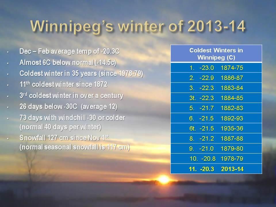
(NOTE: "Winter" is defined as the 3 month period from December through February)
Average winter temperature for Winnipeg : -14.5C (1981-2010 average)


                                             Dec-Feb            Dec-Feb
                                             2011-12              2013-14

Avg temp ........................  - 9.7C .......... -20.3C
diff from normal .................. + 4.8C  .........  -  5.8C
rank out of 141 years......  4th warmest ..... 11th coldest
# of days above normal ........   70    ...........     18
# of days below normal ........   18   ............     66
# of days > 10C below normal    1 .............     25
# of -20C days ....................     24   ............     75  (4th most in 141 winters)
# of -25C days ....................       8   ............     55
# of -30C days ....................       0  .............     27

One can see how this winter has been a complete flip from the winter of 2011-12. This winter is over 10C colder than 2 years ago, with 3.5 times the number of below normal days.  The winter of 2011-12 was the 4th warmest on record in Winnipeg since 1872. This winter has been the 11th coldest, and the 3rd coldest in the last 120 years. Whereas we've seen almost a month's worth of -30C days this winter, there were NONE during the entire winter of 2011-12. Incredibly, there were only 8 days when the temperature went below -25C in 2011-12.. compared to 55 such days this winter. During the winter of 2011-12, there was only 1 day that was abnormally cold (>10C below normal). This winter, we've had 25 such days! It's like we moved 1000 km north this year! What happened?

BLAME IT ON THE JET STREAM

Why the dramatic difference between these two winters?  The simple answer is due to the jet stream. The jet stream is a strong ribbon of air that flows across the mid latitudes and polar regions across the globe, and separates Arctic air to the north from warmer air to the south. It defines the storm track, along which storms are steered as they travel from west to east across the northern hemisphere. In the winter of 2011-12, the jet stream was quite strong but locked in a westerly orientation across the northern Prairies (see right image below), which effectively blocked intrusions of Arctic air from barrelling southward into the Prairies, while also allowing frequent invasions of mild Pacific air to spread east across southern Manitoba. As a result, temperatures were frequently above normal in this setup, with an average of 7 days above normal for every 2 below.  Cold spells were brief and infrequent.

The behaviour of the jet stream dictates what kind of winter
we'll have in southern MB. A wavy jet stream (left) increases
likelihood of a colder winter, while a westerly jet stream (right)
  favours a milder winter with less frequent Arctic outbreaks  
This winter, the jet stream has been locked in a meridional position, that is, north to south instead of west to east (see left image above)  This has allowed frequent invasions of Arctic air southward into the Prairies and eastern North America, while effectively blocking mild Pacific airmasses from moving into southern MB. The result has been the complete opposite of 2011-12, with 7 days below normal this winter for every 2 days above. Cold spells this winter have been frequent and long lasting, while any mild spells have been infrequent and short lived.

So what dictates how the jet stream will set up?   That depends on a number of factors, including large scale climatic oscillations such as the Arctic Oscillation (AO), the North Atlantic Oscillation (NAO), the Pacific Decadal Oscillation (PDO), Madden-Julian Oscillation (MJO) as well as ENSO phases (El Nino, La Nina) The interplay between these oscillations will favour a stronger westerly (aka "zonal") jet stream or a weaker "wavy" jet stream that can vary season to season, and year to year. In addition, some are saying that the rapid melting of the Arctic ice cap is resulting in a weaker jet stream (due to a weaker thermal gradient between the poles and the equator) which would tend to favour a "wavier" jet stream prone to blocking patterns. It's pretty complicated stuff that all depends on global temperatures, winds, ocean currents and ice cover.. so it's easy to understand why it's so difficult to predict what kind of winter we'll have in any given year. Suffice to say, both setups above can result in prolonged periods of abnormally warm or cold weather.. depending on which side of the jet stream you happen to be on.   And based on what's been happening over the past few years, it's possible these types of extreme weather patterns may become more frequent in the future, leading to a greater number of abnormally mild or cold winters in the years ahead. Predictability however will continue to be a challenge, until a better understanding of these global interactions is realized. Until then, hope for the good side of the jet stream!      

Monday, February 24, 2014

Frigid finish for February.. coldest winter in Winnipeg in at least 35 years

Simulation of general upper air pattern this winter
showing lobes from the "polar vortex" (outlined)
pushing south into central North America this year
(image credit: earth.nullschool.net)
Another spell of frigid weather is in store for southern MB this week as the relentless winter of 2013-14 refuses to ease its grip across central and eastern North America. Temperatures this week will be running some 15-20C below normal for the end of February, when highs around -6C in Winnipeg are more usual at this time of year. The coldest weather is expected later this week as a surge of bitterly cold Arctic air plunges in from the north, producing daytime temperatures in the minus 20s and nighttime lows in the minus 30s, temperatures more typical of a cold snap in mid January than late February. No way to sugarcoat it folks.. it's just miserably cold and will stay that way all week.  (We're not alone in our winter misery. Check out article on winter misery index to put this year's harsh winter into historical perspective even in the US)
90 day temperature anomalies across the US (deg F)
showing core of abnormally cold temperatures during winter of 2013-14
over central North America
This latest cold snap will ensure that February finishes well below normal in Winnipeg, the third straight month with well below normal temperatures here. February is on pace to finish with an average temperature close to -20C, some 6.5C below normal for February (normal monthly mean of -13.5C in Winnipeg based on 1981-2010 average) This would make this the coldest February in Winnipeg since 1979 which had a mean temperature of -22.0C.  The next coldest most recent February was in 2003 with a mean temperature of -19.4C.

This frigid February will also cap off what will end up as the coldest winter in Winnipeg in at least 35 years. The overall average winter temperature since December 1st will end up around -20C, the coldest winter here since the winter of 1978-79 which had an average temperature of -20.8C.  That winter was the 10th coldest winter on record in Winnipeg going back to 1872.  The coldest winter on record here was 1874-75 with a mean temperature of -23.0C.  (Average winter temperature in Winnipeg is -14.5C, based on 1981-2010 normals.)

90 day temperature anomalies for
Winnipeg Dec 2013-Feb 2014

Mild days have been rare
TOP 15 COLDEST WINTERS IN WINNIPEG  (since 1872*) 

1.      1874-75 ......... -23.0C
2.      1886-87 ......... -22.9C
3.      1883-84 ......... -22.3C
3T.    1884-85 ......... -22.3C
5.      1882-83 ......... -21.7C
6.      1892-93 ......... -21.5C
6T.    1935-36 ......... -21.5C
8.      1887-88 ......... -21.3C
9.      1879-80 ......... -21.0C
10.    1978-79 ......... -20.8C
11.    2013-14 ......... -20.3C   (updated)
12.    1916-17 ......... -20.2C
13.    1889-90 ......... -20.1C
14.    1872-73 ......... -19.8C
14T.  1875-76 ......... -19.8C
14T.  1949-50 ......... -19.8C


"normal" winter average  ........................  -14.5C (based on 1981-2010 normals)

*NOTE: Winnipeg records from Winnipeg airport (1938-current) and St John's College (1872-1938)

Any hope for a turnaround in March? 

Understandably, winter weary Winnipeggers are eager for a change from the below normal weather pattern of the past 3 months. Unfortunately, current forecasts and past history suggest that March will likely remain colder than normal. Of the top 15 coldest winters listed above,  *ALL* were followed by colder than normal Marches (based on a normal temperature of -5.8C for March, 1981-2010 average) The average March temperature following those 15 top cold winters was -12.2C, or over 6C below normal. The warmest March in the group was 1917 at -6.7C, while the coldest was in 1883 at -15.2C.  

It's easy to understand why March would continue below normal following a very cold winter.  A long cold winter will ensure a deep and persistent snowpack well into March, making it difficult for warm air to surface. Solar energy will either be reflected back into space by the snowcover, or be used to help melt the snowpack instead of warming the air. So a lot of energy is lost due to snowcover. Only when snowcover is gone can more persistent warmth become established. But getting rid of snowcover will take time.. unless there's a major shift in the overall pattern to bring persistently warm weather and some rainfall to accelerate snowcover loss. Such a shift is possible, but history suggests that it's not likely to happen. As a result, be prepared for another colder than normal month in March. That doesn't mean every day will be below normal..  we'll have some mild days in there as well. But overall, colder than normal weather will likely predominate during the month.  Note that days are getting longer and the sun is getting stronger in March, so at least the cold won't feel as intense as the middle of winter. Still, the sooner we get back to "normal" weather, the better.

Wednesday, February 19, 2014

After a brief springlike break, we now return you to our regularly scheduled winter..

Temperature graph past 90 days
for Winnipeg. Mild weather
has been a rarity this winter
It's been a beautiful start to the week across southern MB with sunshine and temperatures near the freezing mark making it feel almost springlike. In fact, Winnipeg airport hit +0.1C Tuesday, it's first day above freezing since January 15th. But alas, the mild respite will be short lived as yet another Alberta clipper tracks across the province tonight with a return to colder weather behind it. This next system is expected to spread snow into Winnipeg and the RRV this evening and continue overnight into Thursday. Snowfall amounts will range from 10 cm through the Riding Mtn Parks and Interlake regions to about 5 cm along the TransCanada corridor (including Winnipeg) and 2 cm or less near the US border. Northerly winds behind this system will tap colder air with temperatures remaining steady or falling through the day. This will usher in another spell of below normal temperatures that will likely persist through the end of February into early March. February is on pace to finish about 5-6C below normal, capping 3 straight months of well below normal temperatures.  This will likely make the winter of 2013-14 the coldest in Winnipeg in at least 35 years (since the winter of 1978-79).

Saturday, February 15, 2014

Milder week ahead.. but first, some snow and blowing snow Sunday night

After 3 straight weeks of below normal temperatures, some milder weather is finally returning to southern MB next week as a milder Pacific flow spreads across the Prairies.  Temperatures in Winnipeg have been below normal since Jan 24th when we hit a high of -2C. Since then, we've gone 22 straight days below normal, with an average temperature of -22C so far this month, over 8C below normal for February.  Temperatures by Monday will be climbing towards the -1C mark, and should stay near or above normal through Thursday (normal highs now are -8C). This will mark our first spell of above normal weather since mid January. Other than that, temperatures have generally been below normal since early December over southern MB.

The milder weather will be ushered in by a warm front which will crossing southern MB Sunday night from the west.  Ahead of the front, a band of snow will spread into southwest MB Sunday afternoon, reaching Winnipeg and the Red River valley Sunday evening.  The band of snow will last about 6 hours and will drop between 4 and 8 cm of snow across southern MB, including Winnipeg. Snow may be moderate to heavy at times and will also be accompanied by strong southerly winds gusting to 60 or even 70 km/h up the Red River valley. This will lead to extensive blowing and drifting snow Sunday evening with poor visibilities especially in open areas where blizzard conditions are possible. Keep that in mind if you have travel plans in the Red River valley Sunday night. Once the band of snow passes overnight Sunday, winds will shift into the west, tapping milder air from Alberta for Monday.

Rob's Obs Snowfall forecast for Winnipeg: Sunday February 16  
(updated 9 am Feb 16)

Start time: 6-8 pm 
End time: 2-3 am (Feb 17)
Snowfall: 4-8 cm, but extensive drifting and blowing snow
Visibility: Generally 0.5-1.5 km, occasionally 400 metres or less in snow and blowing snow
Winds: South 40 gusting 60 km/h during snowfall
Temperature: Steady around -10C during snowfall


Thursday, February 13, 2014

Storm snowfall summary..

Some unofficial snowfall reports from last night's storm system.

Winnipeg .............. 10-12 cm 
Argyle .................. 15 cm
Oakbank .............. 10 cm
Pinawa .................. 10 cm
Brandon ................ 10 cm
St Labre ................ 10 cm
Carman .................  9 cm
Neepawa ..............  9 cm
Baldur .................... 9 cm
Brandon Airport ....  8 cm
Steinbach ............... 7 cm
Winkler .................. 6 cm

NOTE:  These reports are unofficial volunteer observations from various climate observing networks (e.g. COCORAHS, COOLTAP)   Official snowfall observations from airport sites (like Winnipeg airport) are becoming increasingly difficult to obtain due to automation and changes in observing responsibilities.

For Winnipeg, last night's snowfall puts our winter snowfall up to 117 cm since Nov 1st (as measured at my official observing location in Charleswood)  That's right on normal for an entire winter in Winnipeg (based on 1981-2010 normals) yet we still have 2-3 months of potential snowfall left.  For comparison, last year we had 116 cm of snow by mid February (pretty much exactly as this year), with a seasonal total of 172 cm by the end of April.    

Sunday, February 09, 2014

Snowy weather returns this week.. then a warming trend for next week

Snowfall forecast for Winnipeg from NAM model
showing 2 snow events this week
Tuesday afternoon (2 cm) and Wednesday night (10 cm)
(Image from SpotWx) 
After a nice 2 week stretch of dry weather with little or no snow over southern MB, the weather pattern will turn a little more unsettled this week as a couple of clipper systems cross the southern Prairies. The first system is expected to move across southern MB Tuesday into Tuesday evening, bringing a general area of about 2-5 cm of snow, with the highest amounts expected though the Interlake regions. A second stronger clipper system is forecast to move across southern MB and North Dakota later Wednesday into Thursday morning, bringing the potential for 5-10 cm of snow across southern MB along with increasing winds giving areas of blowing and drifting snow. These two systems will bring the first significant snowfall in southern MB since late January.. so be prepared for a return to more winterlike driving conditions this week after a welcome respite so far this month.

The good news is that long range models are pointing to a trend towards milder weather by early next week, with temperature climbing to the freezing mark and possibly even a few degrees on the plus side.