Thursday, January 31, 2013
Bundle up.. it's a cold one out there!
Cold weather is back in Winnipeg and southern Manitoba.. with temperatures today forecast to remain in the minus 20s, and brisk northwest winds of 20-30 km/h producing wind chills in the minus 30s. Even colder air is found over western Manitoba where wind chill warnings are currently in place. For Winnipeg, morning clouds and flurries will give way to clearing skies and sunshine today as a ridge of high pressure over Saskatchewan gradually pushes east. This ridge will move over southern MB tonight giving clear but very cold conditions with temperatures dropping into the minus 30 to minus 35 range. Sunny skies and cold temperatures are forecast for Friday with high temperatures only in the minus 20s. Winds however will be light which will make the cold weather more tolerable. A clipper system is forecast to bring some light snow and moderating temperatures to the RRV Saturday with colder temperatures again Sunday. Long range guidance is indicating a trend towards more normal temperatures next week as the Arctic airmass gradually retreats.
Sunday, January 27, 2013
A history of weather observing in Winnipeg
It's a question that people ask routinely.. what is the temperature outside? And although you can get a reasonable answer from a variety of sources these days from car thermometers to billboard displays, the official answer always defaults to the temperature reading at Winnipeg airport's weather station, the official source of weather observations from Environment Canada. Weather observations started at Winnipeg airport (YWG) in March 1938, and have been a daily ritual ever since, measuring all aspects of Winnipeg weather including temperature, precipitation, wind, pressure, humidity, and virtually anything else that Mother Nature has thrown at us.
As we enter the eighth decade of weather observations at Winnipeg airport, let's take a retrospective look at the history of weather observing in Winnipeg.
Winnipeg's first official weather observations: St John's College (1872 - 1938)
 |
| St John's College Official weather observing station for Winnipeg 1872 - 1938 |
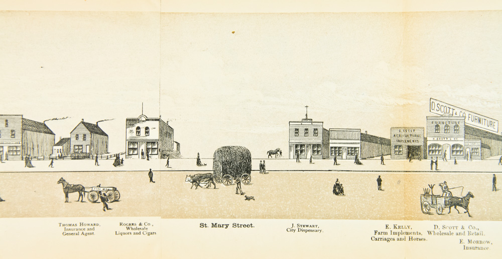
Official weather observations in Winnipeg actually began many years before Winnipeg airport was even around. In 1871, the Canadian federal government established the Meteorological Service of Canada, mainly as a warning service for mariners. To help track and forecast the weather, the department set up weather stations across the country to report on local weather conditions. One of these early stations was established in Winnipeg, first manned by James Stewart, who started preliminary observations around 1870, possibly near Main St and St Mary Ave where he operated a drug store. A November 1872 newspaper article mentions the appointment of James Stewart as the official weather observer for the Winnipeg meteorological station for the Meteorological service of Canada.
 |
| 1911 Winnipeg city map showing location of St John's College off Main Street (north is to the right) |
 |
| James Stewart - Winnipeg's first weather observer |
Although Stewart began weather observations in 1870, continuous archived data is not available until March 1 1872 when official weather records began for Winnipeg. By 1873, the weather observing station was formally established at St John's College on Main St between Church Street and Anderson, near the present day St John's Anglican cathedral (see 1911 city map above showing location of St John's College) An August 1874 newspaper article details news of upgrades to St John's College including upgrades to the meteorological observatory (see image below). The article mentions the addition of a self-registering anemometer on a newly built tower at the College, which suggests that more detailed wind data for Winnipeg (including peak gusts) was available from the St John's College site as early as 1873.

ST JOHN'S COLLEGE METEOROLOGICAL OBSERVATORY - CA 1883
This photo shows the building on the St John's College campus that housed the meteorological observatory, including wind instruments (see tower on roof), ca 1883. Daily weather observations were taken from this location from 1873 to 1932, and sent by telegraph to Toronto and Washington DC to compose weather charts and bulletins. |
| Manitoba Agricultural College U of M, Fort Garry Weather observations were taken here from 1932 - 1938 |
From 1872 to 1888, James Stewart was the official weather observer for Winnipeg sending daily weather observations to the meteorological service headquarters in Toronto. (Suffering from rheumatism, Stewart moved to Prince Albert SK in 1890 where he died in January 1911). It should be noted that the name of William R. Flett also appeared on weather observation forms in the 1870s which indicates James Stewart was not the sole weather observer during this time. Daily weather observations would continue at the St John's College site on Main St until April 1 1932 when the station was moved to the Manitoba Agricultural College
at the University of Manitoba campus in the south end of the city in Fort
Garry. Readings would continue at the university site (still considered part of
the St John's climate record) until the newly formed Winnipeg airport
took over weather observing duties as of March 1 1938.
 |
| Weather observation form - St John's College, Feb 1873 |
The observations from St John's College are recognized as official climate records for Winnipeg, and are included in a merged climate database with Winnipeg airport that extends the city's weather record database to 150 years as of March 1 2021, one of the longest continuous weather observing programs in Canada. A look at the original weather record forms from St John's College reveals detailed observations on the daily weather in Winnipeg using official meteorological instruments of the time, with accurate measurements of temperature, precipitation, wind, pressure, sunshine, etc. The records often included remarks on severe storms and celestial phenomena as well as observations on flora and fauna and river conditions. Overall, the records give a fascinating insight into weather conditions in Winnipeg in the late 1800s and early 1900s that expand the climate record another 65 years beyond the airport observation record. Unfortunately, other than temperature and precipitation data, much of this meteorological data has not been digitally processed and is not available in the online Canadian climate archives. St John's College climate database holds the distinction of having both the hottest and coldest temperatures ever officially recorded in Winnipeg... 42.2C (108F) on July 11 1936, and -47.8C (-54F) on Dec 24 1879. (Click here for historical weather data at St Johns' College between 1872 and 1938.)
WINNIPEG AIRPORT OBSERVATION ERA: March 1938 - present
 |
| Winnipeg Intl Airport ca 1950s known as Stevenson Aerodrome before it eventually became Richardson Intl Airport (YWG) |
In March 1938, Winnipeg International airport (known as Stevenson Aerodrome at the time) began its official weather observing program to support aviation and meteorological services. The observing program relied on human weather observers to record daily weather data, including extremes. In January 1947, hourly observations began at the airport (hourly weather data is available online from January 1953 on). On December 1 1963, the weather station was relocated on the grounds of the newly constructed Winnipeg International Airport (later replaced by the new Winnipeg Richardson Airport in 2011). The human based observing program at the airport continued uninterrupted for 70 years until July 2008 when automation starting taking over weather observing commitments. This marked an important transition in the weather observing program that had been a strictly human based endeavour for over 135 years. (Click here for Winnipeg International airport observations between 1938 and 2008)
JULY 2008: Weather observing program moves towards automation

In July 2008, weather observations for YWG airport switched to an automated system as modern technology and tightening resources necessitated a change in the human observing program. Most of the weather data is now collected automatically from an Automated Weather Observing System, or AWOS for short. A human observer still inputs the data manually including precipitation start and end times, but for the most part, much of the weather observation is taken automatically by the AWOS. An important note here is that snowfall data (including snow depth) stopped in 2008 since AWOS is not able to measure snowfall accurately, and human observers were not required to take snowfall measurements manually. Instead, the AWOS measures only melted snow, ie. the water equivalent of snow that falls. Thus, snowfall data for Winnipeg, which had been taken since 1872, was no longer being observed after 135 years of continuous observations. Snowfall data for Winnipeg is now observed at a nearby volunteer climate station, Winnipeg Charleswood 2, that still takes official snowfall observations for Environment Canada.
On January 17 2013, the automated weather observations at Winnipeg airport were switched to a new AWOS station operated by NavCanada, the agency responsible for aviation services in Canada. This marked the first time that weather observations for Winnipeg airport were not the responsibility of the Meteorological Service of Canada, but a third party. This new weather observing station, known as an HWOS (Human Weather Observation System) relies on automated observations from the weather station, but still requires a human observer from NavCanada to input the full observation (like the previous AWOS setup) Environment Canada has little control over weather data collected at these NavCanada sites. (Note: Hourly weather information for Winnipeg as displayed on Weatheroffice's "current conditions" page comes from this NavCanada HWOS site).
To maintain control of weather data at the Winnipeg airport, Environment Canada has a co-located automated weather station at the airport known as Winnipeg A CS (CXWG). This is a fully automated weather station with no human input for its observations. XWG began its observing program in October 1996. As of October 2013, all official daily highs, lows and precip data for Winnipeg airport come from this site.
To maintain control of weather data at the Winnipeg airport, Environment Canada has a co-located automated weather station at the airport known as Winnipeg A CS (CXWG). This is a fully automated weather station with no human input for its observations. XWG began its observing program in October 1996. As of October 2013, all official daily highs, lows and precip data for Winnipeg airport come from this site.
In summary, here are the list of official Winnipeg observing stations since 1872:
- St John's College: March 1872 - July 1938 (daily & monthly data)
- includes data from Manitoba Agricultural College site 1932-1938 - Winnipeg Intl A: March 1938 - July 2008 (hourly, daily & monthly data)
- Winnipeg AWOS: July 2008 - Sep 2013 (hourly and daily data)
- Winnipeg A CS: Oct 1996 - present (hourly, daily and monthly data)
- *Official climate site for Winnipeg since Oct 2013* - Winnipeg Intl A (NavCanada): Jan 2013 - present (hourly data, daily data from Nov 2018)
WINNIPEG WEATHER STATION LOCATIONS
1872 - PRESENT
1872 - PRESENT

- In September 1938, the wind anemometer at the Winnipeg airport site was mounted on top of a hangar at a height of 20 metres (63 feet), twice the height of the internationally accepted standard of 10 m (33 feet) As a result, wind speeds from the Stevenson airport were somewhat higher than official standards from 1938 until Dec 1 1963, when the anemometer was lowered to the official 10 metre height at the new Winnipeg International airport.
- Water equivalent for snowfall readings began on Nov 1 1960. Before then, water equivalent of snowfall was simply calculated by dividing the snowfall amount by 10 (i.e: 5 inches of snow = 0.50 inches of melted precipitation)
- On July 1 1961, the meteorological day was changed to the synoptic day ending at 06 UTC for precipitation measurements. This correlates to midnight during standard time (Nov - Mar), and 1 am during daylight savings time (Mar - Nov) Prior to July 1 1961, the meteorological day for precipitation measurements was considered the 24 hr period from 630 am to 630 am of the previous day
- On Jan 1 1977, temperature and precipitation values for Winnipeg climate data began using metric standards (i.e., temperatures in degrees Celcius (0.1C resolution), rainfall in mm (0.2 mm resolution), and snowfall in cm (0.2 cm resolution) Prior to that date, temperature and precipitation values for Winnipeg were taken using imperial measurements (i.e., temperatures in whole degrees F, precipitation in inches)
In addition to the airport station, Environment Canada also has an automated station downtown at The Forks (CXWN) which began operation in November 1999. This station has maintained the same automated observation program since inception.
Although equipment and reporting procedures have changed, Winnipeg residents can be rest assured that weather observations continue at Winnipeg airport maintaining a legacy of weather observing in this city that has spanned 150 years.
Winnipeg weather extremes since 1872:
Hottest temperature: 42.2C July 11 1936
Coldest temperature: -47.8C Dec 24 1879
Greatest snow in 24 hours: 38.1 cm March 4 1935
Greatest rain in 24 hours: 152.4 mm June 26 1901
Highest wind gust: 129 km/h Feb 20 1965
Lowest windchill: -57 Feb 1 1996
Highest humidex: 47C Jul 25 2007
Friday, January 25, 2013
A nice break from the cold snap..
After a week long cold spell, a much deserved break from the cold weather will be on the way to southern Manitoba this weekend, with temperatures finally rising to normal, and even above normal values by Sunday. Tonight will be another cold night with temperatures dropping to the -28C mark this evening before temperatures start to rise overnight as winds shift into the southwest and clouds increase. Saturday will be a "transition day" as southerly winds start to push the cold Arctic air out of the Red River valley. Temperatures will be climbing through day reaching the -12C mark by evening. But don't let that "milder" high of -12C fool you. Like most transition days, it will still feel quite cold Saturday as brisk southerly winds of 30 gusting 50 km/h produce wind chills in the minus 30s in the morning, and minus 20s in the afternoon. Sunday is looking like a much nicer day with lighter winds and temperatures reaching above normal highs of -4C in the afternoon. Break out the beachwear! Above normal temperatures are expected to continue Monday and Tuesday before a return to Arctic air by Wednesday with temperatures back into the minus 20s. So enjoy the next few days of milder weather while you can!
Sunday, January 20, 2013
Big chill descends on southern MB..
An extensive Arctic airmass has spread over the Prairies this weekend, and southern MB will be in the grips of it much of the upcoming week. Temperatures will struggle to get above -20C until next weekend, with overnight lows at or below the -30C mark most nights. In fact, Winnipeg airport has already hit the -30C mark this evening (Jan 20th), the first -30C reading at YWG airport since Feb 25 2011. That ended a streak of 693 straight days without a -30C reading, the longest such streak at Winnipeg airport since records began there in March 1938. The only other longer spell of above -30C weather in Winnipeg was from Feb 15 1930 - Jan 29 1932 (714 days) but that record was set at the St John's College observing site closer to downtown, theoretically a slightly warmer location than the airport.
Whatever the case, there is no doubt that this will be the coldest weather we've seen in southern MB for at least two years. Last winter was the 4th warmest winter on record in Winnipeg, and was notable for its lack of snow and cold spells. There was only one 3 day cold spell with temperatures in the minus 20s, from Jan 17-19th 2012. So this upcoming cold spell will seem longer and more intense than usual, but in reality, it's a fairly typical mid winter cold spell for southern MB. Although temperatures will be some 10 degrees below normal much of the week, widespread record low temperatures or record wind chills are not being forecast. Still, the cold weather will come as a shock to residents who have forgotten how cold it can get here in southern MB. Bundle up folks! Relief isn't expected until next weekend into early next week when temperatures should finally rise to normal values for this time of year (highs of -13C), although some snow will likely accompany the warmup as well.
Whatever the case, there is no doubt that this will be the coldest weather we've seen in southern MB for at least two years. Last winter was the 4th warmest winter on record in Winnipeg, and was notable for its lack of snow and cold spells. There was only one 3 day cold spell with temperatures in the minus 20s, from Jan 17-19th 2012. So this upcoming cold spell will seem longer and more intense than usual, but in reality, it's a fairly typical mid winter cold spell for southern MB. Although temperatures will be some 10 degrees below normal much of the week, widespread record low temperatures or record wind chills are not being forecast. Still, the cold weather will come as a shock to residents who have forgotten how cold it can get here in southern MB. Bundle up folks! Relief isn't expected until next weekend into early next week when temperatures should finally rise to normal values for this time of year (highs of -13C), although some snow will likely accompany the warmup as well.
Thursday, January 17, 2013
A little snow and a little milder Friday.. then frigid blast for weekend into next week as coldest air so far this season moves in
 | |
| GEM prog valid 3 pm Friday afternoon showing next clipper system to affect southern MB |
 |
| GEM prog valid 6 am Saturday Strong cold front from clipper will be ushering in cold blast Saturday with wind chills in -30s and areas of blowing snow |
This front will be ushering in the coldest air of the season so far over southern Manitoba for the weekend into early next week, with overnight lows likely dropping into the minus 30s in Winnipeg for the first time in almost two years. Winnipeg's last occurrence of -30C or lower was a -31.6C reading on Feb 25 2011. Lows of -30C or lower are possible Sunday morning through Tuesday morning with highs in the minus 20s. Moderating temperatures are expected by mid to late week over southern MB.
Sunday, January 13, 2013
The week ahead.. Modified cold with occasional snow
 |
| 500 mb pattern for mid week Weather pattern over Prairies will be dominated by strong NW flow aloft between Arctic vortex over Hudson Bay (cold) and strong Pacific ridge (mild) |
Thursday, January 10, 2013
Blizzard warning issued for Winnipeg and Red River valley.. strong winds and snow to give blizzard conditions by Friday night
 |
| NAM model showing position of Colorado low at 6 pm Friday eve. Swath of heavy snow and strong winds will be bringing blizzard conditions to Winnipeg late Fri |
Before the main event, a cold front pushing through southern MB tonight will usher in colder air from the north with some snow or freezing drizzle developing overnight. Snow will continue through the day Friday before it starts intensifying in the afternoon and evening. Snow will become heavy at times, and with strong northerly winds gusting to 70 km/h, blizzard conditions are expected Friday night into Saturday morning, especially outside the city. At this point, it appears that Winnipeg will see about 10-20 cm total snowfall by Saturday morning with this storm, with higher amounts possible outside the city. The snow however will not be the main story, as the strong winds will result in heavy drifting and blowing snow, along with poor visibilities. The western RRV between Winnipeg and Portage will be especially bad given the full fetch of strong NNW winds off Lake Manitoba. Conditions are expected to improve by Saturday afternoon as the storm system tracks into NW Ontario.
Blizzard warnings are issued by Environment Canada for storms that will bring at least 4 consecutive hours of visibilities of 1/4 mile (400 metres) or less in snow and/or blowing snow, along with sustained winds of 40 km/h or more. Specific thresholds of snowfall are not required for blizzard warnings, as they are based on visibility criteria, not snowfall amounts.
Follow the storm on radar! Click on radar viewer from A Weather Moment to follow progress of snow as it heads into southern Manitoba.
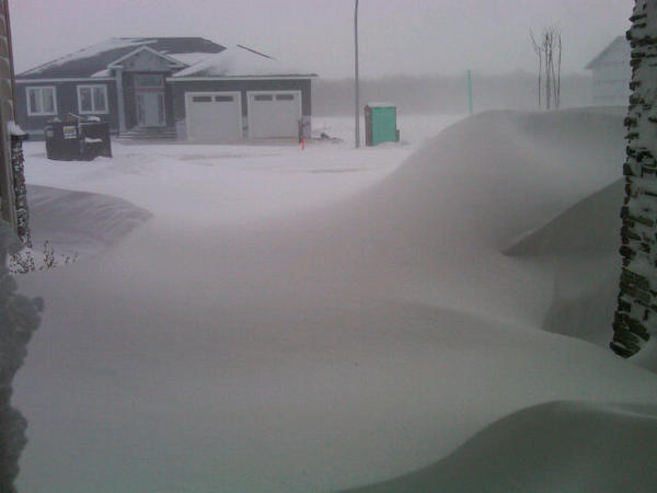 |
| An example of the heavy drifting near Winnipeg caused by Friday's blizzard. Winds gusting to 75 kmh and 10-15 cm snow produced extensive blowing and drifting snow |
Photo tweeted by @loco372
Wednesday, January 09, 2013
Colorado low to impact southern MB Friday into Saturday with snow, strong winds, sharply colder temperatures..
 |
| GGEM model valid Friday evening showing Colorado low tracking into Minnesota. Strong north winds over southern MB will give widespread snow and blowing snow |
 |
| Probability of 20 cm or more of snow from HPC NOAA. Light blue area denotes >50% chance of 20 cm+ |
Snow poll results: Actual snowfall was 13 cm (as measured at my site) 74 poll responses. Most popular reply was 15-20 cm (34 respondents) followed by 10-15 cm (17 replies) "Ensemble" poll average was 15.3 cm
Sunday, January 06, 2013
Mild week ahead.. then turning colder by weekend into next week
It will be a nice reprieve from mid winter cold this week as a mild Pacific flow prevails over the Prairies. Temperatures in southern Manitoba will be some 10-15 degrees above normal, with normal highs running around -13C this time of year. For Monday, a brisk westerly wind will bring mild air from western Canada, with highs approaching the freezing mark over the RRV. On Tuesday, a weather system tracking across southern Manitoba is forecast to bring a band of snow across the RRV, with 2-5 cm possible. Temperatures will remain above normal with above freezing highs possible Thursday. Things will get a little more interesting Friday as a storm system tracks to the southeast of Manitoba, drawing colder air in from the north, along with a threat of snow. It's too early to say how much snow will fall with this system, but the potential is there for 5-10 cm if the system tracks close enough, along with brisk northerly winds and falling temperatures. This storm system will signal a trend to colder weather for the weekend into next week, with a spell of below normal temperatures likely.
Saturday, January 05, 2013
What a difference a year makes...
 | ||
| JANUARY SNOWCOVER - 2012 (LEFT) VS 2013 (RIGHT) Top image shows satellite image of snow cover Bottom image shows webcam image from Emerson |
This year it's been a lot different, but certainly more typical for winter in this part of the world. Winnipeg has seen 75 cm of snow through Jan 1st, about 3 times the amount from last year, and almost twice the normal up to this point. Snowcover is much more widespread across the Prairies, with much of the area covered in a blanket of white (see satellite image above) Snowcover has been greater throughout much of the US as well, with about 65% of the country snowcovered compared to only 23% at the same point last winter. Snowcover is a very efficient heat deflector, as incoming solar radiation reflects off the bright snow surface back into space, making it more difficult for the earth's surface to warm up. The result is colder temperatures, which we've been seeing this winter compared to last winter.
Thursday, January 03, 2013
Winnipeg as seen from international space station
 |
| Winnipeg as seen from ISS space station taken by Chris Hadfield - Jan 3 2013 |
Chris Hadfield has been posting many unique and stunning images of Canada from the ISS as it orbits the earth. Several of these images were posted in this National Post article. Far out!
Wednesday, January 02, 2013
Milder start to the new year
A strong upper ridge of high pressure over the western Prairies is allowing a surge of milder Pacific air to push across the Prairies over the next few days. The bulk of the mild air will be confined over Alberta and southern Saskatchewan, however above normal temperatures are forecast over southern Manitoba into next week as the upper flow becomes more zonal (westerly) This will allow temperatures in Winnipeg to climb to the minus 5C mark or higher at times tomorrow into next week. Long range guidance is indicating that the spell of above normal temperatures is expected to persist into mid to late next week before a return to colder conditions.
Tuesday, January 01, 2013
Rob's Obs now using 1981-2010 normals
Please note that as of Jan 1st, I am now using 1981-2010 normals for Winnipeg monthly temperatures. When referring to monthly "normal" temperatures, a 30 year average is used as the standard for defining "normal". These 30 year averages are generally updated every decade (1951-1980, 1961-1990, 1971-2000, etc) based on EC weather monitoring stations. In Winnipeg's case, these are based on temperature readings from YWG airport.
When looking at the "new" 1981-2010 normals, we see some interesting changes from the previous 1971-2000 normals that we've been using over the last decade (see table below) The most notable difference is how much warmer our winters have become, especially January which now has a "normal" monthly temperature that is 1.4C warmer than the previous 1971-2000 normal. In other words, a "normal" January last decade would now be considered 1.4C below normal using the new 1981-2010 normals.
MONTH ......... 1981-2010 ....... 1971- 2000 ...... difference
normal normal
JAN ................. -16.4C .............. -17.8C ............ +1.4C
FEB ................ -13.5C .............. -13.6C ............ +0.1C
MAR ............... - 5.8C .............. - 6.1C ............ +0.3C
APR ............... 4.5C .............. 4.0C ............ +0.5C
MAY ............... 11.4C .............. 12.0C ............ -0.6C
JUN ................ 16.9C .............. 17.0C ............. -0.1C
JUL ................. 19.6C .............. 19.5C ............ +0.1C
AUG ................ 18.7C .............. 18.5C ............ +0.2C
SEP ................. 12.9C .............. 12.3C ............ +0.6C
OCT ................ 5.1C ............... 5.3C ............ -0.2C
NOV ................ - 4.6C ............... -5.3C ............. +0.7C
DEC ................ -13.5C .............. -14.4C ........... +0.9C
ANNUAL .......... +2.9C ............. +2.6C ............ +0.3C
9 out of 12 months now have "warmer" normals than the previous 1971-2000 values. This has resulted in an annual average that is now 0.3C warmer than the previous annual average. Only May saw a notable decrease (-0.6C) in average monthly temperatures compared to 1971-2000 values.
EC continues to use 1971-2000 normals but plans to move to the new 1981-2010 normals sometime this year (the US has been using them for a couple years now). I don't have the new normals for 1981-2010 precipitation values yet, but will post those as soon as I get them.
Subscribe to:
Posts (Atom)