Sunday, December 21, 2014
Staying mild until Christmas.. then pattern change to colder weather
Today may be the official start of winter, but the unseasonably mild weather of the past two weeks is forecast to continue for the the next few days with temperatures some 10-20C above normal for late December. Highs today and Monday will be near or slightly above freezing with nighttime lows only around -2C, well above normal highs of -11C and lows of -22C for this time of year. The weather will continue to be generally cloudy and dull with a chance of freezing drizzle or light flurries from time to time today into Monday. A storm system tracking into the Dakotas Monday into Tuesday will bring some light snow across the Red River valley and SE Manitoba, with a couple cm possible, especially south and east of Winnipeg. Cloudy and slight cooler conditions are expected behind this system for Wednesday into Thursday (Christmas Eve and Christmas Day) although temperatures will continue above normal, with highs near -5C. A storm system tracking though the Dakotas Thursday night into Boxing Day may bring a round of snow to southern Manitoba, but the main story with this system will be the colder air that will follow in its wake. Temperatures are expected to drop to normal or below normal values for Boxing Day and the weekend into next week, with temperatures in the minus 20s and possibly minus 30s again.
Thursday, December 04, 2014
Major warm-up expected across Prairies, much of North America next week..
 |
| 6-10 day outlook valid Dec 10-14 showing massive warmup over central North America (CPC) |
Friday, November 28, 2014
5-10 cm of snow on the way for Winnipeg
 |
| 24 hr precip amounts in mm to noon Saturday (add 50% for snowfall amounts in cm) |
Tuesday, November 25, 2014
Ready or not.. here comes some mid winter cold..
 |
| NAM model showing surface temperatures (F) Wed morning. Arctic high building in from Saskatchewan will bring in mid winter cold over southern MB |
For tonight, a weak clipper system that has been bringing some light snow across southern MB today will exit the province, with gradually clearing skies tonight from the north. This will allow temperatures to drop well into the minus 20s by Wednesday morning, with some spots in the northern Interlake likely hitting the -30C mark (Moosehorn, Grand Rapids, Berens River, Swan River, etc) In Winnipeg, temperatures are forecast to drop to -26C overnight with light northwest winds creating wind chills near -35 for the morning commute. Temperatures will recover only to around -18C Wednesday under sunny skies, some 13C below normal for late November. Wednesday night into early Thursday will be downright frigid in Winnipeg and the RRV as the core of Arctic ridge crosses the region. That will allow temperatures to plummet towards the -30C mark even in Winnipeg Wednesday night into early Thursday morning.. so make sure you have those block heater cords ready and working! (For the record, the earliest that Winnipeg has hit -30C or lower was on November 19th in 1896 with a reading of -33.9C. Record low for Thursday (Nov 27th) in Winnipeg is -36.1C in 1891, and more recently in Nov 1985, the airport had 5 days of -30C or lower over the last week of November. So believe it or not, it has been worse at this time of year)
A slight moderation is expected by Friday as the next clipper system moves in with some light snow, and high temperatures near minus 10C. Unfortunately, it looks like we're back into the deep freeze over the weekend into early next week behind the clipper system. There are some signs that the abnormally cold pattern will relax a bit by the middle to end of next week, but we'll have to see if those moderating signs continue over the next few days. Until then, bundle up and get prepared for some mid winter cold.. in November!
Friday, November 21, 2014
Mild weekend ahead.. but turning snowy and colder Sunday night. Tricky Monday morning commute likely..
After 2 weeks of well below normal temperatures, southern MB will be getting a brief break this weekend with some milder temperatures as a couple of weather systems track across the central Prairies drawing milder air across the south. Southwest winds ahead of the first system today have pushed temperatures well above freezing over snow-free SW Manitoba with Brandon up to +7C this afternoon and +9C in Pierson. A brisk southerly wind over the snow covered Red River valley was keeping temperatures slightly colder in Winnipeg at -2C this afternoon. For Saturday, a weak ridge of high pressure will cross southern MB giving dry weather and light winds, with temperatures above freezing. By Sunday, a storm system will track across southern MB bringing snow through the Interlake and western MB parklands with 10-15 cm possible by Sunday night. As this system tracks east of the RRV later Sunday, winds will shift into the north and draw colder air into Winnipeg and the Red River valley with snow developing. Snow will continue Sunday night into early Monday along with gusty north winds producing local blowing and drifting snow. It's possible we may see 5-10 cm of snow by the Monday morning commute in Winnipeg although there is still considerable uncertainty on snowfall amounts at this point. Regardless, residents should plan for a slow commute to work or school Monday morning due to sharply colder temperatures, gusty north winds giving local blowing and drifting snow, and slippery road conditions.
Friday, November 14, 2014
Manitoba lakes freezing up quickly
 |
| MODIS satellite image of MB lakes Saturday Nov 8 2014 |
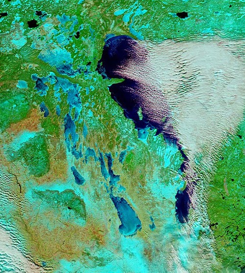 |
| MODIS satellite image of MB lakes Thursday Nov 13 2014 |
Well below freezing temperatures over the past week has brought the first snows of the season over much of southern MB as well as a rapid freeze up of the Manitoba lakes. The two "false colour" MODIS satellite images above were taken just five days apart between Nov 8th (left) and Nov 13th (right) The images show a much different landscape over southern MB over that time with more extensive snow cover (shown in light blue) and a rapid freeze up of the western MB lakes, with Lake Manitoba and Lake Winnipegosis now mainly ice covered. Lake Winnipeg still remains generally ice free except along the shores and some bays.. which is allowing lake effect cloud and flurries to persist as cold winds blow over the open water (open water seen as dark blue on satellite imagery with clouds seen in white) In fact, you can see the bands of heavier lake effect snow over the past day or two immediately south of Lake Winnipeg and Lake Manitoba, with less snow cover elsewhere over southern MB (bare land shows up as light brown)
With a continuation of well below freezing weather over the next 5 to 10 days, ice cover will continue to grow rapidly on the lakes, with Lake Winnipeg likely freezing up by the middle to end of next week. This will effectively shut off the lake effect machine for the season, and will also allow invasions of cold air to spread into southern Manitoba unmoderated by the lakes. Like it or not, winter is here folks!
Tuesday, November 11, 2014
Lake enhanced snowbands may make for tricky morning commute
 |
| Snowfall warning issued for areas south of MB lakes |
Thursday, November 06, 2014
Mild pattern coming to an end.. colder weather on the way this weekend through next week
 | ||
| 6-10 day CPC outlook for next week shows massive outbreak of below normal temps over central and eastern NA |
Monday, October 20, 2014
Nice fall weather this week
Temperatures will be running well above normal this week over southern Manitoba as an upper ridge of high pressure builds over the eastern Prairies. Sunny skies and gusty south winds Tuesday will send temperatures into the mid to upper teens, with lows 20s likely across SW Manitoba. On Wednesday, clouds will increase ahead of a weak system crossing southern Manitoba that may trigger some scattered showers by afternoon or evening. Temperatures however will remain mild in the mid to upper teens. Sunshine will return for Thursday and Friday with temperature again in the mid to upper teens, some 10C above normal for late October. Slightly cooler conditions are expected early next week, although there are no indications at this point of a change to a prolonged below normal temperature pattern through the end of October.
Thursday, October 02, 2014
Big change in the weather pattern Friday into the weekend.. strong winds, colder temperatures and possible snow..
 |
| Wind and wave impact maps for south basins of Lakes Winnipeg (right) and Manitoba (left) Severe impacts are possible Friday Oct 3rd along south shorelines (in red) (image from province of Manitoba) |
 Video: See video footage of waves at Twin Lakes on southeast shore of Lake Manitoba Friday. (from CBC)
 |
| Snowy scene Friday afternoon near Lake Brereton, MB in the Whiteshell Park area, just one week after experiencing 30C temperatures |
Thursday, September 25, 2014
Record blast of late season heat over southwest Manitoba
 |
| 4 pm temperatures across RRV and SW MB - Sep 25 2014 Temperatures soared into the 30s over SW MB |
 |
| Record highs across the central Prairies Sep 25 2014 (Graphic from The Weather Network) |
Friday should be a repeat day over southern MB, with temperatures in the upper 20s and low 30s once again along with sunny skies and humid conditions (dewpoints again in the upper teens) Southerly winds however will be stronger Friday in Winnipeg and up the RRV, with gusts to 60 km/h or more. Temperatures should climb to a high of 28-29C in Winnipeg, just shy of the record high for Sept 26th of 31.7C set in 1952. Saturday will see one more warm day over the Red River valley with highs in the mid 20s, before a cold front pushes through by afternoon. This front will usher in much cooler air by Sunday with highs only in the low teens along with periods of rain. So enjoy these last couple of summer like days before reality kicks back in!
UPDATE: Fri Sept 26: It was another unseasonably warm day across southern Manitoba with temperatures climbing to the 30C mark or higher in most areas. Winnipeg hit a high of 30.2C, some 15C above normal for Sep 26th, and just 1.5C shy of the record high for the day. In addition, humidity values were unusually high for late September with dewpoints of 18C through midday, resulting in a peak humidex reading of 36C by late afternoon, the latest in the season that Winnipeg has hit a 35C+ humidex since humidex records began in 1953 (previous latest on record was a 38C humidex on Sep 19 2004). The hot spot in the province and country today was Swan River at a sizzling 35.1C.
Sunday, September 21, 2014
Fabulous first week of fall ahead!
 |
| Great harvesting weather is expected this week across southern MB with dry and warm conditions (photo by Shawn Dziuk near Glen Ullin, ND) |
Sunday, September 14, 2014
Warming trend this week
After an early taste of fall like weather, temperatures will be returning to more normal values this week over southern Manitoba as a large cool airmass pushes east out of the Prairies. In its place, a moderating trend will become established over much of the Prairies as a zonal upper flow develops, allowing milder air from western Canada to spread east across the Prairies into southern Manitoba. This will allow temperatures to climb into the upper teens over the next few days and lower 20s later this week, which is near or even a bit above normal for this time of year (normal high for Winnipeg is now 18C) High temperatures Wednesday may dip into the mid teens as we get sideswiped by a cold front pushing through the Interlake into NW Ontario, but then temperatures should rebound quickly for late week into the weekend and next week. In addition, the weather should remain generally dry this week over southern Manitoba until Friday when a system will bring the next main threat of showers. The upcoming warmer and drier weather pattern will be most welcome by farmers looking to ramp up harvesting activities after an unsettled first week and cool second week of September.
Saturday, September 06, 2014
Enjoy the summerlike weekend.. an early blast of fall coming by Tuesday
 |
| Say goodbye to summer this week! 850 mb temperature map shows blast of cold air flooding across the Prairies by late Monday |
Wednesday, September 03, 2014
Another round of rain..
 |
| WPC 24hr rainfall forecast (in inches) valid Wed to Thur evening |
Sunday, August 31, 2014
Soggy end to wet but warm August..
It was a wet finish to the month of August over Winnipeg and the Red River valley as another weather system brought widespread rain to southern Manitoba today. In general about 15-25 mm of rain fell in most areas, with 20 to 40 mm over parts of the southern RRV and southwest MB. In Winnipeg, the official rainfall at the airport today was 18 mm, with 17 mm falling at the Forks. At my location in Charleswood, I picked up 21.6 mm today bringing my monthly total to 137 mm.. well above the August average of 77 mm. The bulk of this month's rain has fallen over the past 2 weeks, with a couple of significant rainfalls across the city including August 21st when a slow moving thunderstorm complex dumped 50-100 mm over the southwest to central parts of the city. Officially, the airport recorded 104 mm this month, while the Forks had 133 mm with amounts over 170 mm from the Tuxedo to Linden Woods area.
The wet finish to the month was in sharp contrast to a dry July and first half of August which saw below normal precipitation in Winnipeg. Temperature-wise, August will finish with an average temperature around 19.3C at YWG airport.. slightly above the average August temperature of 18.8C.
Saturday, August 23, 2014
Areas of heavy rain tonight into Sunday morning.. severe thunderstorm risk Sunday afternoon/evening
 |
| WPC 48 hr rainfall forecast (inches) through Monday 70-80 mm noted through Interlake and western MB with 30-50 mm over the RRV including Winnipeg |
 |
| EC Summary of rainfall amounts over weekend |
Friday, August 22, 2014
Torrential rains swamp Winnipeg
 |
| 6 pm radar shows nearly stationary thunderstorm complex over SW Winnipeg into downtown core |
 |
| In one of the more popular images from Thursday's deluge, a resident snorkels in floodwaters in Whyte Ridge (SW Winnipeg) where 80 mm of rain fell in 90 minutes. |
 |
| Flooded underpass at Higgins Ave.. one of several underpasses that were flooded in Thursday's deluge |
 |
| For some, a canoe offered a better mode of transportation on flooded city streets |
Select rainfall amounts from Thursday's deluge.. (unofficial)
 |
| Rainfall amounts over south Winnipeg from WeatherFarm mesonet |
Whyte Ridge ............ 81 mm
U of Winnipeg .......... 65-75 mm
Tuxedo .................... 70 mm
Waverly South ......... 70 mm
Grant Park ............... 65 mm
Linden Woods ......... 56 mm
Forks (EC) .............. 53 mm
Charleswood ............ 41 mm
St Vital .................... 25 mm
Winnipeg airport ....... 19 mm
Transcona .............. 5 mm
This was the second time this week that the Tuxedo to Linden Woods area has been hit with heavy rainfall. On Monday afternoon, a narrow band of heavy showers and thunderstorms dumped 35 to 50 mm along this swath. Tuxedo Park school recorded 49 mm Monday with another 70 mm Thursday, for a total of 119 mm within 4 days. Linden Woods has recorded 109 mm since Monday. Normal August rainfall is 77 mm in Winnipeg.
City of Winnipeg rainfall - Aug 21 2014 (between 4 and 10 pm)
 The following is a map from the city of Winnipeg showing the distribution of rainfall in the city from Thursday's rainstorm. One can see the heaviest rain axis stretching from the southwest Perimeter into the downtown core up towards North Kildonan. The maximum was in the Whyte Ridge area which saw over 80 mm of rain between 530 and 730 pm. (NOTE: The Fort Whyte station recorded an erroneously low number on this map due to a plugged gauge) The city has a network of over two dozen rain gauges scattered throughout Winnipeg to monitor rainfall within the city, which can vary widely in short distances during convective storms (which is the primary mechanism for precipitation in the summer months here) This network of stations helps give the city a much more detailed picture of rainfall distribution within Winnipeg, compared to only 2 official Env Canada sites in the city (Winnipeg airport and The Forks) Link to City of Winnipeg rainfall map.
 Monday, July 14, 2014
Nice warming trend this week.. risk of thunderstorms over weekend
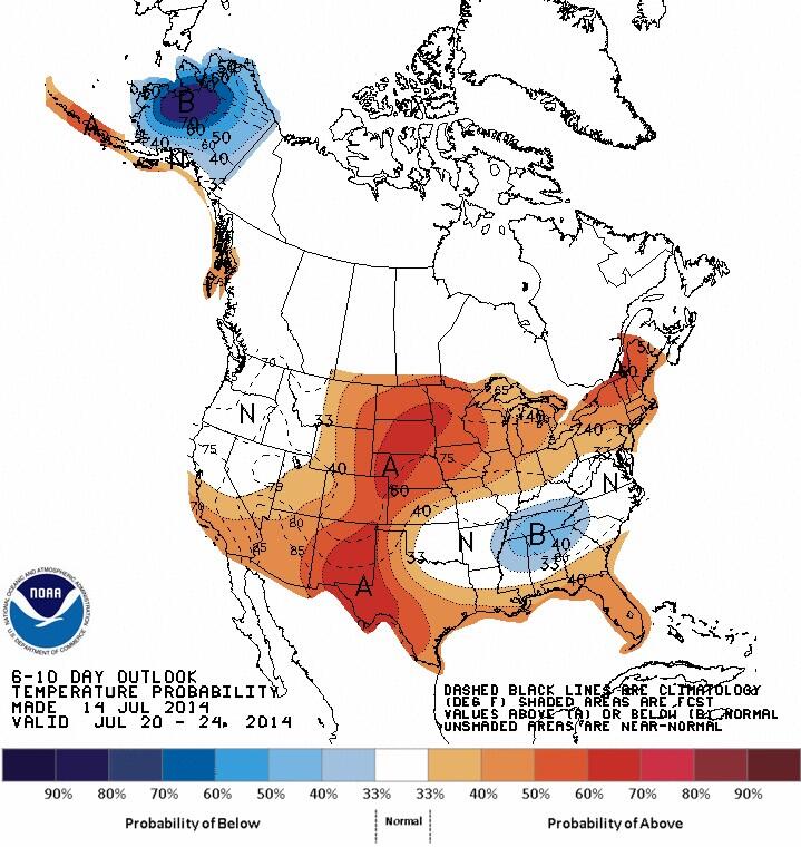 |
| CPC 6-10 day outlook valid Jul 20-24 indicates return of warmer air over southern MB |
Wednesday, July 09, 2014
Seasonably warm weather ahead.. but another cool outbreak Sunday into early next week as heat wave builds over BC
 |
| Looking for heat over the next week? Head west! CPC 6-10 day outlook looks cool for southern MB/Ontario. |
Tuesday, July 01, 2014
June 2014: A "normal" month temperature wise.. but much wetter than usual..
 |
| June 2014 - Winnipeg Airport Daily temperature graph and anomaly from normal |
Rainfall was a different story. A total of 147.1 mm fell at YWG airport during June, some 57 mm (63%) above the 30 year June average of 90 mm. According to JJ's Winnipeg weather blog, this makes this June the wettest June in Winnipeg since 2000 (177 mm) and the city's 12th wettest June since records began in 1872. Totals were even higher in other parts of the city with 167 mm at my location in SW Winnipeg, and 170 mm at the Forks downtown. It also didn't help matters that much of the rain fell over the last 3 weekends of the month, spoiling summer weekend plans for many. The rain however was even worse over western Manitoba which was deluged with record rainfall during June. In Brandon, their June rainfall total of 251.6 mm was the wettest month on record since records began in 1890. Previous wettest month was August 1980 at 217 mm. The bulk of the rain fell over the last two weeks of the month, leading to widespread overland flooding over southwest Manitoba. Rivers and lakes are at very high to record high levels across southern Manitoba, with flood warnings and high water advisories on many lakes and tributaries. The abnormally wet conditions prompted the opening of the Red River floodway on July 1st to ease the risk of flooding in the city of Winnipeg.
So is there any hope of drier weather the rest of the summer? Too hard to say. The next few days look promising with drier weather for the balance of the week. Increasing heat and humidity over the weekend will lead to a greater chance of showers and thunderstorms developing over southern Manitoba, but hopefully the activity will be more scattered and transitory compared to the past few episodes. Beyond that, there are no clear signals as to how the rest of the summer will shape up. Certainly there's a lot of moisture around which helps to fuel more shower and thunderstorm activity. But a favourable upper pattern can shut off the taps for long stretches as well. We're approaching the peak of summer now (mid July is our summer peak in terms of average temperature), and hopefully Mother Nature starts to take a much-needed summer break soon!
Tuesday, June 24, 2014
Another unsettled weekend ahead.. showers and thunderstorms likely, locally heavy at times
Another weekend, another shot of unsettled weather coming up for southern Manitoba as a warmer and more humid airmass spreads over the eastern Prairies, while periodic weather systems trigger showers and thunderstorms Friday through Sunday. Much like last weekend, this upcoming weekend won't be a total washout with sunny, dry stretches at times. However, occasional showers and thunderstorms are likely each day, especially at night with the potential for some severe thunderstorms.. along with locally heavy rainfall. This will not be welcome news for those hoping to dry out from the wet weather over the past couple of weeks which has produced over a month's worth of rain in Winnipeg within a week. Cooler weather is expected to move in next week behind this unsettled weather pattern.
Thursday, June 12, 2014
Unsettled weekend ahead.. wet Sunday likely for Dads and runners..
After some dry and pleasant weather this week, it looks like things will be getting more unsettled this weekend over Winnipeg and the Red River valley as a pair of weather systems affect the region. The first wave of precipitation is expected to move in Friday night into Saturday morning ahead of a warm front pushing up from North Dakota, possibly giving 5-10 mm to Winnipeg by Saturday afternoon (although some models are showing much less.. only a couple mm with the first wave). We'll get a bit of a break Saturday afternoon before another wave of rain moves in Saturday night into Sunday as a more potent system intensifies over northern Minnesota. That will likely bring steadier and heavier rain for Father’s Day (and the Manitoba Marathon) with 15-25 mm possible for Winnipeg. Not the best timing on the weekend, but the rain will be beneficial for farmers in the Red River valley, and most marathon runners would rather run in the rain than in the heat. Rain is expected to taper off later Sunday into Sunday night as the system pulls east.
Sunday, June 01, 2014
Warm finish to May salvages slow start to spring..
 |
| Temperature departure from normal for last week of May shows core of warmth over northern Plains/southern MB (finally!) |
The warm weather included the season's first 30C weather in Winnipeg, with highs of 33.3C on May 24th (record high) and 32.7C on May 29th. . These marked the hottest May days in Winnipeg since 1995 and the first time since 1995 that we've seen two or more 30C days in May. Amazingly, this hot weather came only 10 days after a trace of snow was recorded on the 14th, the only snow of the month. Rainfall for the month was only 42 mm at YWG airport.. about 75% of the normal May rainfall of 54 mm. All in all, a summer like end to May, much appreciated by long suffering residents of southern Manitoba!
For more details on May statistics, see JJ's Winnipeg Weather blog May summary.
Friday, May 23, 2014
The heat is on! 30+C temperatures Saturday.. record highs possible
It's been a long wait, but summer like heat is finally back in southern Manitoba as a warm southerly flow draws up above normal temperatures over the province. Under mainly sunny skies today, Winnipeg airport climbed to 29.6C, the warmest temperature here since last September 6th when it hit 33.6C. And tomorrow is looking even warmer as the peak of this warm airmass moves over southern Manitoba. Temperatures Saturday are expected to hit the 30C mark in Winnipeg and much of southern Manitoba, with values as high as 33C possible in some areas. If we do hit 30C, it will mark the first 30C day recorded in May in Winnipeg since May 2007 (31.3C on May 9th) Some record high temperatures are likely Saturday in southern Manitoba, including Winnipeg which will challenge the record high of 32.7C for May 24th set in 1980. By Saturday afternoon and evening, a band of thunderstorms is expected to fire up over western Manitoba along a weak cold front which will push into the Interlake and northern RRV areas by evening. Locally heavy downpours, strong wind gusts and hail will be possible with some stronger storms before weakening Saturday night. Unsettled weather with scattered showers or thunderstorms are expected Sunday over Winnipeg and the Red River valley as the weak front slowly advances east.
Wednesday, May 14, 2014
Warming trend into holiday weekend..
The week is off to a chilly start over southern Manitoba with single digit temperatures and even some snowflurries in Winnipeg early this morning. Skies are expected to clear off overnight allowing for sub-freezing temperatures by Thursday morning. Thursday should be a much nicer day with sunshine, light winds and afternoon highs around 11-12C.. still well below normal for this time of year (normal highs now are near 20C), but much better than today's brisk single digit temperatures. Tomorrow will signal the beginning of a warming trend that will take us into the Victoria Day holiday weekend with temperatures climbing to the 20C mark by Sunday along with partly to mostly sunny skies. Unfortunately, it looks like wet weather will be moving in for holiday Monday with showers and temperatures in the mid teens.
Monday, May 05, 2014
Unsettled week ahead..
The weather this week will become increasingly unsettled as a series of disturbances track across southern Manitoba. The first system will be spreading an area of rain or showers into southern Manitoba Tuesday, first across western Manitoba reaching Winnipeg and the Red River valley by midday or afternoon. Rainfall amounts are not expected to be heavy across Winnipeg/RRV with about 5-10 mm possible through Tuesday night.. although heavier amounts of 15-25 mm are expected over parts of western Manitoba. Another disturbance is expected to bring a second round of showers across southern Manitoba later Wednesday into Wednesday night, with another 5-15 mm possible. Drier weather is expected Friday and Saturday, with near normal temperatures in the mid to upper teens possible. Unfortunately, it looks like another system will bring in wet weather for Mother's Day Sunday. All in all, a somewhat unsettled week ahead.. with temperatures trending towards normal by late week.
Wednesday, April 30, 2014
April ends on cool damp note as below normal streak continues..
 |
| Same story.. different month Below normal temperatures dominated in April, much like March and February |
Latest dates that Winnipeg first reached 20C (data since 1872)
1. May 25 1907
2. May 21 1956
3. May 18 1996
4t. May 17 1935, 1967
6t. May 16 1883, 1892, 1979
9. May 15 1884
10. May 14 1902
Source: Environment Canada
Saturday, April 26, 2014
Another round of wet weather moving into southern Manitoba Sunday night through Monday
 |
| RDPS model valid midday Monday Apr 28th showing widespread precip from US storm system |
Monday, April 21, 2014
Wet weather moving in for mid week..
More typical springlike weather has finally become established across southern Manitoba as the winter snowpack has pretty much disappeared across most areas. This is allowing the late April sun to warm up the surface more easily, with temperatures reaching more seasonable values now. Tuesday looks to be a beautiful day with lots of sunshine and temperatures reaching the mid teens.. pretty much normal for this time of year. The nice weather however will be short lived as a large storm system developing over the western Prairies brings a widespread area of rain across southern Manitoba during Wednesday, reaching Winnipeg by late afternoon or evening. Rain will become steadier and heavier Wednesday night, with a good soaking of 15 to 25 mm possible through Thursday, likely our most significant rainfall since last October. Rain will taper off Thursday night, possibly changing to some wet snowflurries by early Friday as colder air works in behind the system. Cooler than normal weather will follow in the wake of this system through the weekend into early next week. This will ensure that April finishes below normal by a good 4-5C, the 7th straight month that has ended up below normal in Winnipeg. The last month that was above normal here was last September which finished 2.5C above normal. Hopefully, May can finally break the below normal streak..
Sunday, April 13, 2014
Record cold possible this week before warming trend for Easter holiday weekend..
Well below normal temperatures will once again flood into southern Manitoba over the next few days in the wake of yesterday's storm system that brought snow, ice pellets and patchy rain or drizzle across the area. Temperatures are expected to remain below freezing through Thursday before milder weather moves in by the end of the week. Temperatures for the first half of the week will be more typical for early March than mid April, with highs around -5C and lows near -15C, well below normal for this time of year (normal highs are now +10C, normal lows -2C) In fact, some record low maximum and minimum temperatures will be challenged this week in Winnipeg, especially Tuesday and Wednesday.
Record temperatures for Winnipeg this week.
DATE......... REC LOW MIN ........... REC LOW MAX ..... Forecast low/high this week
Mon Apr 14 .... -16.7C (1893) ....... -7.8C (1880) ............ -14/-6
Tue Apr 15 ..... -16.7C (1893) ........ -6.7C (1875) ............ -17/-6
Wed Apr 16 .... -16.7C (1875) ...... -4.4C (1910) ............ -13/-5
Thu Apr 17 ..... -13.3C (1953) ........ -3.3C (1953) ............ -12/-2
Normals for the period: High +10C, Low -2C.
Note that Winnipeg has never recorded a temperature colder than -15C after April 16th so temperatures this week represent some of the coldest weather on record for so late in the year here. The good news is that there are signs of a significant warmup by the Easter holiday weekend, with temperatures climbing to double digit values again. We can only hope the latest cold spell this week is winter's last hurrah after what has been a much too long stay this year. Over the past 11 weeks, Winnipeg has seen only 10 days above normal. The graph below shows daily temperature departures for Winnipeg over the past 90 days, which clearly shows an overly persistent pattern of well below normal temperatures since late January (in fact, since the beginning of December) We're well overdue for a pattern change..
 |
| Daily temperature departures for Winnipeg over the past 90 days. Mother Nature needs a major reboot |
Saturday, April 12, 2014
Like it or not.. here comes the snow..
 |
| 640 am Woodlands radar and webcam images showing progress of snow across southern MB early this morning |
Follow this blog, my webcam page, MB highways, and AWM radar to keep track of this latest bout of wintery weather.
UPDATE: Snowfall reports from April 12th
Mafeking ............ 22 cm (north of Swan River)
Cowan ............... 18 cm (east of Swan River)
St Claude ............ 15 cm (south of Portage La Prairie)
Rossburn ............ 14 cm (southwest of Riding Mtn Park)
Carman .............. 10 cm
Brandon .............. 5-10 cm (5 cm at YBR airport)
Neepawa ............ 9 cm
Miami ................. 9 cm
Gilbert Plains ....... 8 cm
St Alphonse ........ 7 cm (south of Spruce Woods Park)
Portage LP ......... 7 cm
High Bluff ............ 7 cm (east of Portage La Prairie)
Morden ................ 6 cm
Winkler ................ 5 cm
Pinawa ................. 5 cm
Marquette ............ 5 cm (east of Portage La Prairie)
Stony Mtn ............ 4 cm
Winnipeg ............. 2 cm (5 mm melted precip with ice pellets, rain and drizzle)
Thursday, April 10, 2014
After a springlike week, back to some winter this weekend..
Spinglike weather finally made an appearance over southern MB this week with the first double digit temperatures of the season in Winnipeg Wednesday (high of +10.4C), and almost 20C temperatures over the southwest RRV (19.3C in snowfree Morden) The mild temperatures have made a significant dent in the snowpack across southern MB, with most areas west of the Red River valley and south of the TransCanada now snow free. Here in Winnipeg, snowdepth at my location has dropped to 14 cm this morning after being at 40 cm just last weekend. Snowcover should continue to go down over the next couple of days as daytime temperatures remain above freezing.
But don't put away the snowshovels and boots just yet! Believe it or not, indications are that Winnipeg and much of southern MB will be seeing more of the white stuff this weekend, especially Saturday as a couple of disturbances track across the southern Prairies, while colder air flows in from the north. The first wave of snow is expected to spread over SW MB and along the US border Friday night into early Saturday, before another disturbance from central Saskatchewan brings a second wave of snow across the western Parklands into the Red River valley through Saturday, including Winnipeg. There is still a lot of uncertainty about how much snow will fall with these systems due to temperatures hovering near the freezing mark, but it's possible Winnipeg and the RRV could see 5-10 cm of snow Saturday, while some higher elevations of western MB may see 15 cm of snow or more. Colder air will follow in the wake of these systems with daytime highs remaining below freezing early next week, well below normal for this time of year (normal highs now +9c). Temperatures are expected to moderate by the end of next week with near normal temperatures again by next weekend. Until then, get ready for another taste of winter.. hopefully the last parting shot of the season!
But don't put away the snowshovels and boots just yet! Believe it or not, indications are that Winnipeg and much of southern MB will be seeing more of the white stuff this weekend, especially Saturday as a couple of disturbances track across the southern Prairies, while colder air flows in from the north. The first wave of snow is expected to spread over SW MB and along the US border Friday night into early Saturday, before another disturbance from central Saskatchewan brings a second wave of snow across the western Parklands into the Red River valley through Saturday, including Winnipeg. There is still a lot of uncertainty about how much snow will fall with these systems due to temperatures hovering near the freezing mark, but it's possible Winnipeg and the RRV could see 5-10 cm of snow Saturday, while some higher elevations of western MB may see 15 cm of snow or more. Colder air will follow in the wake of these systems with daytime highs remaining below freezing early next week, well below normal for this time of year (normal highs now +9c). Temperatures are expected to moderate by the end of next week with near normal temperatures again by next weekend. Until then, get ready for another taste of winter.. hopefully the last parting shot of the season!
Saturday, April 05, 2014
After coldest 4 month stretch in 115 years, spring weather finally returning to southern Manitoba
It's been a long tough winter in southern Manitoba, but springlike weather is finally returning this week as temperatures rise well above freezing for the next 7 days at least. The stubborn source of Arctic air that has persisted over central Canada for the last 4 months is finally showing signs of retreating back north, which will allow more seasonable temperatures to spread across southern Manitoba this week. Normal highs are now +7C in Winnipeg, as we enter the climatogical period when snow cover has normally disappeared in the Red River valley. This of course is not the case this year as snowdepths of 25-50 cm are still prevalent across much of the northern valley, including Winnipeg (officially 40 cm at my place as of this morning) However, the upcoming spell of mild temperatures will make a big dent in the snowpack by the end of the week, and it's likely some parts of the Red River valley will be snowfree by next weekend. The big melt this year is coming 2-3 weeks earlier than last year when the snowpack didn't disappear until April 27th in Winnipeg, thanks to prolonged cold weather that didn't see temperatures rise above +5C at Winnipeg airport until April 24th, the latest date on record. The good news with this week's big melt is that no significant precipitation is expected until at least next weekend, which will ease major flooding concerns. Nonetheless, the rapid melt this week will likely result in ponding of water in poor drainage areas as well as rising water levels in ditches.
Update on March stats: March finished with an average temperature of -12.7C in Winnipeg, the 19th coldest March on record, and the coldest March since 1996 (-13.0C) The month averaged almost 7C below the 1981-2010 March average of -5.8C. This made the 4 month period of December-March the coldest such period in Winnipeg since the winter of 1898-99 with an average temperature of -18.4C (tied with 1898-99) During that 4 month period, Winnipeg saw 90 days with temperatures of -20C or lower.. the 6th most since 1872. For more details, see Winnipeg weather blog post on this year's harsh winter.
Update on March stats: March finished with an average temperature of -12.7C in Winnipeg, the 19th coldest March on record, and the coldest March since 1996 (-13.0C) The month averaged almost 7C below the 1981-2010 March average of -5.8C. This made the 4 month period of December-March the coldest such period in Winnipeg since the winter of 1898-99 with an average temperature of -18.4C (tied with 1898-99) During that 4 month period, Winnipeg saw 90 days with temperatures of -20C or lower.. the 6th most since 1872. For more details, see Winnipeg weather blog post on this year's harsh winter.
Saturday, March 29, 2014
March going out like a lion as major winter storm set to impact North Dakota, northern Minnesota, NW Ontario, SE Manitoba Monday
 |
| RDPS model valid Monday evening showing large winter storm system grazing southern Manitoba |
 |
| Blizzard watches (light green) and winter storm watches (blue) are in effect south of the US border |
 |
Projected snowfall amounts (inches) from WPC/NOAA. Map shows swath of heaviest snow setting up between Grand Forks and Fargo through northern Minnesota into NW Ontario where 20-30 cm is possible Sunday night into Monday night
Thursday, March 27, 2014
Cold end to March.. but a gradual moderating trend next week. Hopeful signs that we may be finally turning the corner in April?
March will be ending much like it began.. below normal (although not quite as cold as the the -37C we had on March 1st!) Clear skies and light winds will allow temperatures to drop to the -20C mark yet again early Friday, which would be the 15th time this month with a daily temperature of -20C or lower (normally, March only sees 5 such days in Winnipeg, and usually in the first half of the month). After a chilly start, Friday should see a nice afternoon with highs near -5C, still well below normal for this time of year, but feeling much nicer with sunny skies and light winds. The weekend looks somewhat unsettled as a weak clipper system tracks across southern Manitoba. This system will push a warm front across the area with a chance of some light snow ahead of it Saturday morning, before southerly winds bring in milder air for the afternoon as temperatures climb above the freezing mark to +2C in Winnipeg (which is actually normal for this time of year) We may even see our first rain since early November Saturday night as a band of showers moves through the Red River valley ahead of a cold front. The mild air will be short lived however as the system advances east Sunday, with brisk northerly winds developing behind the system Sunday bringing falling temperatures. This will set the stage for a cold last day of March on Monday with temperatures some 10-15C below normal. March will likely finish with an average temperature around -12.7C in Winnipeg, about 7C below normal (normal March temperature is -5.8C based on 1981-2010 averages) and the coldest March in Winnipeg since 1996 (average temperature of -13.0C). And according to local Winnipeg weather statistician "JJ" (from Winnipeg weather blog), this would make this the coldest December-March period in Winnipeg in 115 years (since the winter of 1898-99) In other words, we've just been through the coldest 4 month stretch in Winnipeg in over a century!
(Check out this creative tribute to our endless winter to the "Sounds of Silence" - Winnipeg Free Press)
But the news isn't all grim. The outlook for the rest of next week calls for a moderating trend with temperatures climbing through the week, with highs rising above the freezing mark by mid to late week. There are hopeful signs that this MAY be the start of a more significant and prolonged pattern change to milder weather as we get into mid April. But be forewarned, Aprils following very cold winters in Winnipeg are usually colder than normal.. thanks to a later than usual snowmelt. Hopefully, a milder start to April will accelerate the return of spring to southern Manitoba.
Sunday, March 23, 2014
Frigid first weekend of "spring".. late season -30C weather over southern Manitoba as cold Marches on
The official first weekend of spring was anything but springlike over southern Manitoba as a frigid Arctic airmass brought abnormally cold temperatures to the area, averaging some 15-20C below normal for late March. After a brisk Saturday when temperatures struggled to an afternoon high of -13C in Winnipeg (along with -25 windchills), clear skies and light winds allowed temperatures to bottom out to a frigid -28.4C at Winnipeg airport early Sunday morning. Although well below normal (average highs are now +2c, lows -8C), it was not a record low for the day (-32.2C on March 23 1974) Temperatures this morning were even colder outside the city, with several sites recording lows below -30C, abnormally late for such temperatures even for southern MB.
Cold spots across southern Manitoba (March 23 2014)
Great Falls ........ -33.6C (Pine Falls)
Gimli .................. -33.4C
Fisher Branch .... -32.2C
Wasagaming ..... -32.3C
Indian Bay........... -32.0C (Falcon Lake)
Pinawa .............. -31.5C
Victoria Beach ... -31.0C
The cold conditions are just an extension of what southern Manitoba has been experiencing for the last 4 months now with consistently below normal temperatures. Over the past 9 weeks for example, only 9 days have been above normal in Winnipeg. The cold conditions will gradually ease over the next few days but temperatures will remain below normal much of the week before a moderating trend gets temperatures closer to normal by the weekend. So far, March is averaging around -13C in Winnipeg, well below the average March temperature of -5.8C (1981-2010 normal) The below normal temperatures this week will ensure that March finishes as the city's 6th consecutive month below normal.
Thursday, March 20, 2014
Spring arrives.. on the calendar only..
 |
| Projected snowfall amounts (cm) tonight into midday Friday |

Subscribe to:
Posts (Atom)