Friday, October 30, 2015

A mild October.. will mild pattern continue through November?

October 2015 was another mild month over the Prairies with temperatures averaging some 2-3C above normal over western and central Canada. In Winnipeg, the month finished with an average temperature of +7.1c, or 2.1C above the normal October average of +5.0C (30 year average). The mild weather comes on the heels of a warm September that finished 3C above normal, and was Winnipeg's 6th warmest September since 1872. The combined Sep-Oct average temperature of 11.5C made it Winnipeg's 9th warmest such period since 1872. (30 year average is +8.9C)


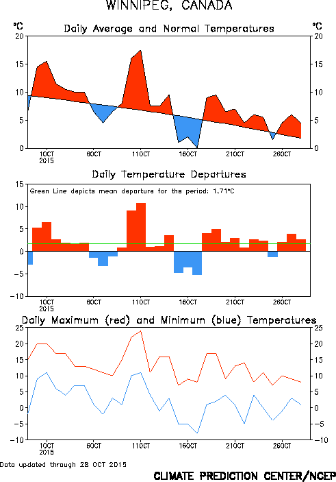
Map of temperature anomalies (left) showing widespread warmth in October over western North America. 30 day temperature graph for Winnipeg (right) showing dominance of above normal temperatures during October.  

Weather outlook for November 2015

According to NOAA, the mild weather pattern is expected to continue through much of November across the Prairies, with generally above normal temperatures over the next 2-4 weeks. (see maps below)  This doesn't mean warm weather every day, but generally a greater frequency of above normal temperatures during the next month.


CPC temperature outlooks maps for early and late November
 (8-14 day outlook left, and 3-4 week outlook right) 


The mild pattern appears to be in response to a very strong El Nino that has developed over the Pacific this year, and is currently on track to be one of the strongest El Nino episodes recorded since reliable records began in 1950. As of October, the 3 month averaged El Nino index was at +1.5 and expected to climb to +2 or higher by December, the strongest El Nino since 1997, regarded as the strongest El Nino event since 1950.  

Backgrounder: 2015 El Nino 

 Top: Graph of Oceanic Nino Index since 1950 showing strongest ENSO events
Lower: Graph of this year's El Nino ocean temperature anomalies expected to peak by December 

Note that Winnipeg had its second warmest winter on record in 1997-98, thanks to the unusually strong El Nino that year. That winter saw very little snow through December, with only a trace of snow on the ground in Winnipeg on Christmas day. The winter finished with an average temperature of -8.2C, a whopping 6C above normal, and the second warmest winter on record in Winnipeg, second only to that of the incredibly mild winter of 1877-78 (another very strong El Nino year)


NOAA winter outlook for Dec 2015-Feb 2016 showing greater odds
for drier and warmer than normal winter over Prairies


Will El Nino bring mild weather for Grey Cup? (Nov 29 2015 in Winnipeg)    

Grey Cup organizers and football fans are hoping that the mild weather pattern so far this autumn will continue through November, or at least through Nov 29th when the 103rd annual Grey Cup is scheduled at Winnipeg's Investors Group Field. Normal highs in Winnipeg by the end of November are around -6C, with lows of -14C. Temperatures on Nov 29th however have ranged from a high of +6C to a low of -33C (based on Winnipeg airport data since 1938). Last year, Winnipeg saw a high of -8.7C on Nov 29th with a low of -19.6C, and a game time temperature of -16C with strong northerly winds of 40 km/h giving windchills of -28 to -30. Officials are hoping for much milder conditions this year as footballs fans gather for the annual football finale. Given previous El Nino patterns, there are better odds this year that temperatures will be warmer than normal in Winnipeg for the end of November. Crunching some numbers from similar El Nino patterns in the past shows about a 55% chance of above normal temperatures for late November this year (highs > -4C), a 25% chance of below normal temperatures (highs < -7C) and a 20% chance of near normal temperatures (-4 to -7C)

So it appears that milder than normal conditions are favoured for the Grey Cup this year. If so, it would be the third consecutive time that Winnipeg has hosted the Grey Cup with mild weather (along with 2006 and 1998). But as any sports fan will tell you, underdogs can always win a game. So although mild weather is the odds on favourite this year, it only takes one storm system to bring in an untimely shot of snow and cold weather to southern Manitoba at the end of November, even during an El Nino year. This year's strong El Nino would lower the odds of that happening, but you can't rule it out completely. So let's hope the mightly forces of the El Nino Zephyrs from the west prove too strong for the punishing attack of the Arctic Express from the north. Go team El Nino!!


EXTREMES FOR NOV 29 USING PRE-AIRPORT CITY DATA BACK TO 1872

RECORD HIGH: +  7.2C (1932)
RECORD LOW:  -36.7C (1875)


PREVIOUS GREY CUP WEATHER IN WINNIPEG:
NOV 19 2006 ........Clear. High + 1.5C, low -9.2C.   Kickoff temp: -3C
NOV 22 1998 ....... Sunny. High + 9.7C, low: 0.6C.  Kickoff temp: +5C. Record mild day!
NOV 24 1991 ....... Sunny. High - 15.6C, low: -21.9C. Kickoff temp: -16C

WEATHER FACTORS THIS YEAR:
- Very strong El Nino pattern favours milder than normal conditions for late November
- 55% chance of highs > -4C on game day, 25% chance of highs < -7C


Sunday, October 11, 2015

Powerful winds expected overnight through Monday morning.. gusts of 100 km/h or more expected.

After an unseasonably warm and pleasant Thanksgiving weekend, the weather will be taking a dramatic turn tonight into Monday as a pair of cold fronts push across southern Manitoba. The first cold front is pushing through this evening and will shift balmy south breezes into the west with temperatures falling into the teens. A few showers and isolated thunderstorms are possible along this front with westerly wind gusts of 60 km/h possible. The second cold front will be pushing through the RRV early Monday morning, ushering in powerful NW winds and much cooler temperatures in the single digits.. a dramatic difference from Sunday's almost summerlike weather. The big story Monday however will be the winds.. with sustained north to NW winds of 60-70 km/h gusting to 100 km/h or more at times. This can lead to roof and tree damage as well as local power outages.  The strongest winds are expected between 4 am and noon in Winnipeg and the RRV, before the winds start diminishing somewhat in the afternoon (but still strong into the early evening)        

Note that a rare STORM force wind warning has been issued for Lake Manitoba and the south basin of Lake Winnipeg for Monday morning. Storm force wind warnings are issued for winds of 48 knots (90 km/h) or greater on the lakes. These warnings are seldom issued and are used only for the strongest windstorms on the lakes. As a result, mariners and cottage owners need to be prepared for very strong north to northwest winds off the south end of the lakes gusting to 100 km/h or more overnight through Monday morning, with major crashing waves causing local shoreline erosion. This is NOT a time to be on the water, so stay onshore Monday until winds subside.

So batten down the hatches.. a major change in the weather is on the way!  

POST SUMMARY..

Strongest wind gusts reported Oct 12 2015 
(EC and MB ag-wx stations) 

Starbuck .............. 104 km/h
Gretna ..................100 km/h
Victoria Beach ....... 96 km/h
Emerson ................ 96 km/h
Elm Creek ............. 96 km/h
Altona ..................  95 km/h
Winnipeg .............. 94 km/h
Treherne ............... 94 km/h
Morris ................... 86 km/h
Gimli ..................... 86 km/h


Tuesday, October 06, 2015

Some rain on the way Wednesday, then clearing skies with a warm Thanksgiving weekend ahead

A quick moving low pressure system will cross southern Manitoba Wednesday bringing an area of rain into the Red River valley by mid to late afternoon into the evening. The bulk of the rain is expected between 4 pm and midnight in Winnipeg and the RRV with general amounts of 5-10 mm expected. Amounts up to 15 mm are possible in some areas where embedded convection will generate locally heavier showers at times. Rain will move out of southern Manitoba overnight Wednesday with clearing skies expected Thursday as a ridge of high pressure builds in from the west. That ridge will cross southern Manitoba Friday bringing sunny skies and seasonable temperatures in the mid teens.

The outlook for Thanksgiving weekend looks fantastic with well above normal temperatures expected. As the ridge moves east of Manitoba, a southwest flow of unseasonably warm air will spread across all of the Prairies Saturday and Sunday, sending temperatures soaring into the 20s along with plenty of sunshine. Temperatures in Winnipeg could be approaching record highs by Sunday (current record high for Sunday Oct 11th is 26.1C on Oct 11 1942) A cold front is forecast to push through southern MB Sunday evening with a chance of showers, followed by  somewhat cooler conditions for holiday Monday (but still above normal with highs of 16-18C) All in all, looks like a great holiday weekend to enjoy fall weather at its finest!   

Friday, October 02, 2015

September 2015 Highlights


See Winnipeg weather for additional details on September 2015 weather.