 |
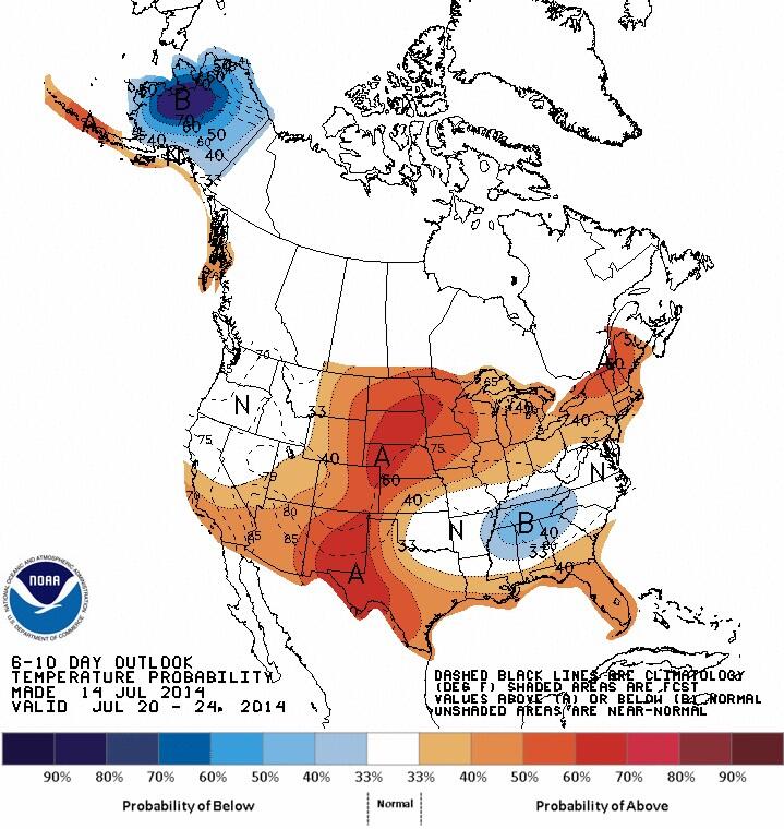
| CPC 6-10 day outlook valid Jul 20-24 indicates return of warmer air over southern MB |
Monday, July 14, 2014
Nice warming trend this week.. risk of thunderstorms over weekend
Wednesday, July 09, 2014
Seasonably warm weather ahead.. but another cool outbreak Sunday into early next week as heat wave builds over BC
 |
| Looking for heat over the next week? Head west! CPC 6-10 day outlook looks cool for southern MB/Ontario. |
Tuesday, July 01, 2014
June 2014: A "normal" month temperature wise.. but much wetter than usual..
 |
| June 2014 - Winnipeg Airport Daily temperature graph and anomaly from normal |
Rainfall was a different story. A total of 147.1 mm fell at YWG airport during June, some 57 mm (63%) above the 30 year June average of 90 mm. According to JJ's Winnipeg weather blog, this makes this June the wettest June in Winnipeg since 2000 (177 mm) and the city's 12th wettest June since records began in 1872. Totals were even higher in other parts of the city with 167 mm at my location in SW Winnipeg, and 170 mm at the Forks downtown. It also didn't help matters that much of the rain fell over the last 3 weekends of the month, spoiling summer weekend plans for many. The rain however was even worse over western Manitoba which was deluged with record rainfall during June. In Brandon, their June rainfall total of 251.6 mm was the wettest month on record since records began in 1890. Previous wettest month was August 1980 at 217 mm. The bulk of the rain fell over the last two weeks of the month, leading to widespread overland flooding over southwest Manitoba. Rivers and lakes are at very high to record high levels across southern Manitoba, with flood warnings and high water advisories on many lakes and tributaries. The abnormally wet conditions prompted the opening of the Red River floodway on July 1st to ease the risk of flooding in the city of Winnipeg.
So is there any hope of drier weather the rest of the summer? Too hard to say. The next few days look promising with drier weather for the balance of the week. Increasing heat and humidity over the weekend will lead to a greater chance of showers and thunderstorms developing over southern Manitoba, but hopefully the activity will be more scattered and transitory compared to the past few episodes. Beyond that, there are no clear signals as to how the rest of the summer will shape up. Certainly there's a lot of moisture around which helps to fuel more shower and thunderstorm activity. But a favourable upper pattern can shut off the taps for long stretches as well. We're approaching the peak of summer now (mid July is our summer peak in terms of average temperature), and hopefully Mother Nature starts to take a much-needed summer break soon!
Subscribe to:
Posts (Atom)