 |
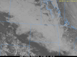
| Visible satellite image of eastern Prairies Mar 19 2013 showing extensive snowpack over MB, SK and ND. Snowdepths are generally 50-75 cm across much of the Assiniboine and Red River basins |
Select snowdepths as of this morning (March 19) across southern MB and vicinity..
Winnipeg airport .................. 45 cm (AWOS)
Winnipeg Charleswood ........ 58 cm (COOLTAP)
Carman ................................ 69 cm (COOLTAP)
Miami ................................... 57 cm (COOLTAP)
Portage La Prairie ................. 71 cm (COOLTAP)
Brandon A ............................ 77 cm (EC)
Pilot Mound .......................... 82 cm (AWOS)
Winkler ................................ 63 cm (COOLTAP)
Morris ................................. 68 cm (COCORAHS)
Emerson ............................... 60 cm (COCORAHS)
Steinbach .............................. 57 cm (COCORAHS)
Pinawa .................................. 55 cm (COCORAHS)
Estevan SK ............................. 38 cm (EC)
Grand Forks .......................... 35 cm (NWS)
Fargo .................................... 50 cm (NWS)
Is there an analogy with the spring of 1956? If EC's records are correct, remnants of the snowpack persisted until May 2 that year at Winnipeg Airport!
ReplyDeleteCheck out the springs of 1996 and 1997 as well. Interestingly, there was about one month of below-normal temperatures after the snowpack disappeared in these three years, followed by normal or above-normal summers.
ReplyDeleteKeep in mind that 35cm snow depth in Grand Forks as our office measures it in an open field to the east of the office that is subject to major blowing. In town much closer to 50-55cm
ReplyDeleteAndrew..
ReplyDeleteEvery year is different, but generally if the airport had at least a 25 cm snowdepth at the end of March, it took at least until the second or third week of April for the snowcover to disappear. (using airport snowdepth stats from 1955-2003) 1955 was an exception, when a 35 cm snowpack on March 31st disappeared by April 5th. 1964 and 1965 saw deep March end snowpacks disappear by April 10th or so. As you point out, the years of 1956, 1996, and 1997 had the latest snowpack melts.
Click on "snowpack stats" for a table of when snowpack disappeared in Winnipeg based on airport snowdepth stats 1955-2003
When will snowpack dissapear this year? No idea, but let's hope we're not matching 1956 or 1997 dates! Cast your vote on latest Robs Obs poll.
Rob
Well, good news as far as flooding fears go, in the short term anyways. Long range guidance is indicating no major storm systems affecting southern MB through the next week to 10 days, with a slow moderating trend in temperatures. That is exactly what is needed to start eroding this snowpack slowly and gradually. However, it's still early and we'll have to see what happens in April.. but generally speaking, looks like ideal weather for the next 7 to 10 days anyways.
ReplyDeleteDon't worry about flooding. Officials said they already took that early March storm into account in their previous forecast, plus accounted for an "unfavourable" scenario which still didn't result in major flooding.
ReplyDeleteTrust the experts (he wrote with a snarky grin on his face).
A flood update was issued 2 days ago.
ReplyDeletehttp://news.gov.mb.ca/news/index.html?archive=&item=17037
They say it's unlikely that we'll have prolonged river flooding and high lake levels.
7am temps:
ReplyDeleteYWG: -24.1C
XWG: -24.0C
XWN (The Forks): -18.3C
Beautiful day on tap with strong March sun and light winds making it feel warmer than -9C this afternoon. Temperature readings will likely be some 5C warmer in the city due to urban heat island effect which is quite pronounced this time of year when snow is still on the ground.
ReplyDeleteFargo expecting major flooding. Also Pembina.
ReplyDeletehttp://www.cbc.ca/news/canada/manitoba/story/2013/03/21/mb-fargo-top-five-floods-in-history.html
I'd like to see spring as much as the next guy, but these bright snow days are fantastic.
ReplyDeleteYeah, that strong March sun certainly helps make the below normal temperatures more tolerable, especially with light winds. At least we're doing better than other parts of Canada including Saskatchewan, and even the Maritimes.
ReplyDeleteBy the way, for those keeping track.. Winnipeg's average March temperature so far this month is running around -12C, which surprisingly isn't even in the top 20 coldest Marches in Winnipeg! (since 1872) So even with the below normal temps this last week, we likely won't set any records for cold weather this March (hard to believe after being so spoiled last year) Coldest March on record in Winnipeg was back in 1899 at a January like -16.1C, the only March on record where we stayed below freezing all month. We have yet to climb above freezing this month as well, although long range guidance is indicating we may sneak above 0C by the 30th or 31st.
Regardless, this March will likely be the coldest since at least 2002 (-11.7C) and possibly 1996 (-13.0C)