Tuesday, February 27, 2007

More snow Thursday?


After a week of almost daily snowfall, the snow has finally eased over Winnipeg and southern MB today although some flurries are still likely today. About 20 cm of snow has fallen over Winnipeg since last Monday although daily snowfalls have generally been 5 cm or less. Now it looks like another low pressure system will move across the central U.S. Plains over the next couple of days, bringing another round of snow over Southern MB Wednesday night into Thursday. Similar to the storm this past weekend, the bulk of the snowfall with this storm is expected to stay mainly south of the international border (note that a winter storm watch is in effect for North Dakota and Minnesota for Wednesday afternoon into Friday with the potential for 30 cm of snow or more). However there will be an area of snow moving into southern MB Wednesday night into Thursday that could bring 5 to 10 cm of snow over and south of the Trans Canada corridor with higher amounts possible if the storm moves a little further north. Stay tuned!

Monday, February 26, 2007

Rain in the Gauge? Spring must be near!

You may have noticed my station is starting to record "rainfall" today. Well, it's not rain, but actually snow that has accumulated in the rain gauge and is now melting with the milder temperatures and occasional sunshine. This will be a more common occurrence over the next few weeks as temperatures get warmer, and sunshine gets stronger. Just another sign that spring is just around the corner! (although it's hard to see around the corner with all these snowbanks!)

Friday, February 23, 2007

Winter Storm losing strength..

Well, it's looking like this winter storm will not have as much of an impact on Winnipeg and the Red River valley as initially feared, at least not today anyways. The initial wave of snow that was to arrive this morning is a lot less extensive and intense than first thought.. with drier air making it more difficult for the snow to surface. As a result, Winnipeg will end up having only marginal amounts of snow today and tonight.. maybe a couple of cm at most. Also winds aren't as strong here as initally expected so blowing and drifting will not be as bad. The bulk of the snow today and tomorrow should fall northwest of Winnipeg through the Riding Mountain area where 10 to 20 cm is expected today through Saturday. Now, eventually, more significant snow should make its way into Winnipeg as this system slowly moves across the US plains.. but now it looks like the bulk of the snow in Winnipeg won't fall until later Saturday into Saturday night when 5 to 10 cm may fall. By then however winds will be a lot lighter, so blowing and drifting shouldn't be a major problem.

Bottom line.. not as bad as first thought for Winnipeg today.. but snow will eventually make its way in over the weekend.

Thursday, February 22, 2007

Winter Storm Watch posted for Southern MB


Looks like more snow on the way for Southern MB! A storm system developing over Montana will spread an area of snow over southern Saskatchewan this afternoon into tonight which will move into southern MB on Friday. The snow should taper off Friday night into Saturday as the main energy of the storm shifts into the central U.S. Plains where a major storm system is expected over the weekend with the potential for severe thunderstorms and tornadoes over the southern plains. For Southern MB, snow should move into southwestern areas overnight reaching Winnipeg Friday morning. Gusty east to southeast winds up to 60 km/h will accompany the snow giving considerable blowing and drifting snow. The heaviest snowfall accumulations will likely be over the higher elevations west of Winnipeg from the Riding Mtns to Pilot Mound where 10 to 20 cm of snow is possible by Saturday. Further east, including Winnipeg, less snowfall is expected.. with perhaps 5 to 10 cm by Saturday. The problem however will be the winds which will give poor visibilities in snow and blowing snow, especially through Friday afternoon into Friday evening in the Winnipeg area. Stay tuned on this developing storm system. Note.. this storm may bring near blizzard conditions to parts of southern Saskatchewan tonight into Friday.. so be prepared for poor tavelling conditions if you have travel plans out west tomorrow.

Wednesday, February 21, 2007

Snow moving across Southern MB


A low pressure system crossing Southern MB this morning is bringing a fairly narrow but intense band of heavy snow generally north of the Trans Canada highway. Near zero visibilities are being reported in this swath of heavy snow that extends from Lake Manitoba across the southern interlake area into southern Lake Winnipeg (including the communities of St Laurent, Tuelon, Inwood and Winnipeg Beach). This axis of heavy snow is generally sliding eastward so the heaviest snow should stay just to the north of Winnipeg, mainly confined north of Highway 67. 10 to 15 cm of snow is possible along this swath with snowfall rates of 2 to 3 cm per hour at times. Further south, "wrap around" snow from this system will move in from the west this morning, giving about 2 to 5 cm of new snow generally along and south of the TransCanada, including Winnipeg. Increasing north to northwest winds today will produce blowing and drifting snow, with near blizzard conditions possible this afternoon in open areas over the Red River Valley.

Friday, February 16, 2007

Jan 2007 warmest on record globally


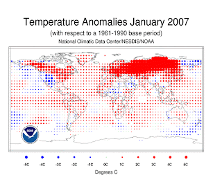
NCDC has just released their climatic perspective on January 2007, and it shows that globally, January 2007 was the warmest January on record since records began in the late 1800s. The record warm month was in large part due to exceptionally mild temperatures over Europe and Siberia which had one of their warmest and snowfree Januarys ever. Say what you will about global warming, but it's becoming pretty difficult to deny that the earth's climate is getting warmer. There is still some debate over how much mankind is contributing to or enhancing this warming but you have to wonder though, maybe Al Gore is right...

Wednesday, February 14, 2007

The end is near!

..The end of the cold snap that is! The Arctic vortex that has held Southern MB in its grip for the past two to three weeks is finally showing signs of breaking down by the weekend. As a result temperatures will finally climb to normal and even above normal values over the next few days, and should remain above normal next week. In the meantime, we have one more cold night to endure tonight as temperatures once again fall to the minus 30 degree mark at the airport. The moderating trend will begin tomorrow as brisk southerly winds start to push out the Arctic airmass, although wind chills will still make for a cold day. Milder conditions are expected on Friday with highs climbing into the minus single digits for the first time since January 26th. A brief cooldown is expected on Saturday but then gusty southerly winds will begin bringing milder air again for Sunday into Monday. Currently, the forecast high for Sunday is +1 which is likely a little optimistic given that southerly winds are forecast, which tends to trap colder air in the Red River valley. Nonetheless the trend towards milder conditions is forecast through all of next week, which will be a welcome change for cold weary Manitobans!

Sunday, February 11, 2007

Remember snow?

It's been pretty boring over southern MB lately with nothing but clear and cold conditions for the past two weeks. We haven't had any appreciable snowfall in Winnipeg since that big 30 cm snowfall at the end of December. So to remind us what snowstorms can look like, I thought I'd post some photos from Oswego county, NY where they have been buried with almost 10 FEET of snow over the past week due to persistent heavy lake effect snow off Lake Ontario. The above photo is from Mexico, NY which has seen 103" of snow over the past 7 days. For more amazing photos from this extreme snowfall event.. click here. (lots of photos...not recommended for dial up users)

Saturday, February 10, 2007

Deep freeze continues.. some relief by end of next week?

The deep freeze continues over Southern MB and much of central and Eastern Canada. The big question now is.. when will it end??!! Long range guidance is hinting at some relief by the middle to end of next week over the Prairies with the Arctic vortex (shown above) finally showing some signs of breaking down. Temperatures in Winnipeg, which have averaged some 12 degrees below normal so far this month, may finally get back to a normal high of -9 by next Thursday or Friday with even -5 or so possible by next weekend! Break out the sunscreen! After that, it's anyone's guess as to how things will develop with long range models showing a wide range of solutions ranging from below to above normal temperatures to end off February (basically at this point, a non-forecast.. will have to wait and see)

Friday, February 09, 2007

Update to Rob's Obs page

I added a map plot of Winnipeg city temperatures on my main webpage (courtesy of Weatherbonk.com) These plots have always been available as drop down link choices, but I thought it would be interesting to have the current temperature map display as a static image on the website. It can be quite useful to see how temperatures in the city differ from the airport site as has been discussed in recent threads. I've also added a couple of other weather graphs from my station to balance out the look. Apologies to those of you still on dialup who will now find it slower to load my webpage! By the way, you can access any city temperature plot in the world by simply inputting the city name in the entry form at the bottom of the map... a quick way of getting real time temperatures anywhere you want! (provided they have weather stations)

Tuesday, February 06, 2007

Currently in Winnipeg, it's -27C... or is it?

Well turn on the radio or look on the web, and you'll find that the current temperature in Winnipeg is -27C as of 1 pm. However, a look at weather stations in and around the city tell a different story. Most stations in the city are around -22C with even some -19C readings around St Vital. (see Google map of Winnipeg area temperatures) So why the big difference from the "official" temperature? That's because the official temperature is taken from the Winnipeg airport weather station, which is located in a remote field in the northwest part of the city. Most times of the year, or if it's windy, there's not a big difference between the airport temperature and the rest of the city. However under clear and cold conditions with a light northwest flow, the airport site is usually several degrees colder than the city itself since it's getting cold air drainage from surrounding snow covered fields. In the city itself however, that light northwest flow is modified by buildings, trees, pavement, etc. so that temperatures can be several degrees warmer than at the airport.. sometimes as much as 5 to 10 degrees warmer. This is known as the "urban heat island effect". This effect will become even more noticeable over the next few weeks as the sun gets stronger and warms up the city core even more. So cheer up.. it's not really -27C, it's a balmy -22C instead! (unless you're standing in a field on the northwest side of the airport!)

Monday, February 05, 2007

Winnipeg hits -40C mark..

.WINNIPEG AIRPORT REGISTERS FIRST MINUS 40C READING IN 3 YEARS..

CLEAR SKIES AND LIGHT WINDS ALLOWED TEMPERATURES TO DROP TO THE
MINUS 40C MARK AT THE WINNIPEG AIRPORT EARLY THIS MORNING WITH A
LOW OF -41.7C. THIS MARKS THE FIRST -40C READING IN WINNIPEG
SINCE JANUARY 30 2004 WHEN A LOW OF -41.0C WAS RECORDED. THE
-41.7C READING THIS MORNING HOWEVER DID NOT SET A RECORD LOW FOR
TODAYS DATE WHICH IS -43.3C SET BACK IN 1895.

TEMPERATURES WERE NOT QUITE AS COLD IN THE CITY ITSELF WITH THE FORKS
DOWNTOWN WEATHER STATION RECORDING A LOW OF -33C. OTHER UNOFFICIAL
WEATHER STATIONS IN THE CITY REGISTERED LOWS AROUND -36C EARLY
THIS MORNING. THE WINNIPEG AIRPORT TENDS TO REGISTER COLDER READINGS
IN CLEAR AND COLD AIRMASSES WITH A LIGHT NORTHWEST FLOW.

What a way to start a Monday..

Sunday, February 04, 2007

Deep Freeze to continue through next weekend..

There's no end in sight to the current deep freeze that has settled over Southern Manitoba. Daily highs in the minus 20s and lows in the minus 30s (even close to -40 at times) will persist through the week into next weekend. The good news is that wind speeds will be light over the next couple of days so wind chills won't be a problem. However winds are expected to pick up by Wednesday and Thursday which will likely produce dangerous wind chill values again. (Note that official wind chills are calculated with a wind speed of at least 13 km/h) Little change in the below normal temperature pattern is seen through next weekend into next week. So make the best it... or if you're lucky enough, a good time to get out of town!

Saturday, February 03, 2007

-40C tonight??

Temperatures have already fallen to -35C at the Winnipeg airport as of 8 pm this evening.. and with clear skies and a light northwest flow, conditions are favourable for the airport site to drop to the -40C mark overnight. Note however that temperatures in the city are several degrees "warmer" as of 8 pm this evening, ranging from -27 at the Forks to -30 in the outskirts. You will notice that the Winnipeg airport site can get quite a bit colder at night than the rest of the city in a light northwest flow and clear skies. The weather station at the airport is located in a remote field on the northwest side of the airport, which seems to get some dramatic cold air drainage or radiative cooling in a light northwest flow. In these cases, the temperature at the Winnipeg airport is not very representative of the temperature elsewhere in the city.. which are often some 5 degrees "warmer" than the airport. This can easily be seen when looking at a Google map of city temperatures.

Regardless.. whether it's -35 or -40.. it's going to be a bitterly cold night!

Friday, February 02, 2007

Latest February Outlook from CPC

Weakening El Niño To Exert Little Influence — Following an overall mild December and most of January, the current chill over much of the U.S. will persist through early February, according to seasonal forecasters at the NOAA Climate Prediction Center. Below-normal temperatures are expected to dominate the central and eastern part of the country through early February with more moderate temperatures projected for the final weeks of the winter season. (Click here for the full CPC report.)

CPC is forecasting the current below normal pattern to persist for the next week to 10 days before a moderation in the second half of February. EC on the other hand is forecasting below normal temperatures right through February. Time will tell who's right.. but one thing's for sure, we're in for a frigid week here in Southern MB!