Sunday, March 31, 2013

Cold March ends on... what else.. a cold note..

30 day temperature graph
for Winnipeg showing
abnormally cold weather
through March 2013
After a couple of days which seemed to hint that perhaps spring was finally on the way, colder air has once again returned over southern MB with brisk northwest winds and below normal temperatures today. It's a fitting end to what has been a long and frustratingly cold March which saw little in the way of thawing temperatures to help erase a 40-60 cm snowpack in Winnipeg and throughout the Red River valley. Snow cover was still 40 cm deep in Winnipeg as of March 31st, the deepest snow cover this late since 1996.  There were only 2 days this month where the temperature rose above freezing at Winnipeg airport, March 28th and 30th, with a maximum of only +2.3C on the 28th. (Consider that March 2012 had an average monthly temperature of +2.2C!) Normally, Winnipeg sees at least 15 days above freezing in March with at least 1-2 days reaching 10C or more. Temperatures this month have been below normal every day since March 10th, with the coldest weather of the month between the 13th and 21st.. about the same time a record March heat wave was occurring just a year earlier. March 2013 will finish with an average temperature of about -11C, some 5C below normal for March and the coldest March in the city since 2002 (-11.7C) It also was a remarkable 13C colder than March 2012.

March 2013 mean
temperature anomalies
shows extent of cold
weather this month
The outlook this week calls for a continuation of below normal temperatures, with a brief moderation around Wednesday. Not much in the way of precipitation is expected this week, although there are hints of a possible storm system tracking through the Dakotas by next Saturday that may bring some precipitation over southern MB. Longer range outlook calls for a hopeful sign of a pattern change to warmer weather by mid April as the stubborn Arctic block relaxes. Let's hope! 

Saturday, March 23, 2013

Dry weather through the end of the month.. Mother Nature takes a March break

5 day total precip from GLB-GEM
March 23-28 2013 showing generally
dry weather over southern MB
Pleasant late winter weather is on tap for Winnipeg and the Red River valley over the next week, as a blocking ridge of high pressure keeps weather systems away from southern Manitoba.  This means that no significant precipitation is expected over the RRV through the end of the month, which is welcome news for those growing increasingly concerned about our deep snowpack and delayed snowmelt.  Temperatures will continue below normal through mid week, with daily highs still below freezing through Wednesday or Thursday but with generally sunny weather. It's possible we may finally climb above the freezing mark by next weekend, which would be the first time since January 10th that Winnipeg has seen a temperature above 0C. (Today will mark Winnipeg's 72nd straight day below freezing)  Since 1872, there's been only one March where the temperature stayed below freezing all month. That was way back in 1899 during Winnipeg's coldest March on record (monthly mean of -16.1c)  As it stands now, March 2013 is averaging around -12C for the month, about 6C below normal (and a whopping 14C colder than March 2012), in what will likely be the coldest March in Winnipeg since at least 2002 (-11.7C)      

Mean monthly temperature comparison  - March 2013 (left) vs March 2012 (right)


The above maps show the incredible difference between this March (left) and March 2012 (right). In 2012 an exceptionally large area of anomalously warm temperatures was found over the central US into central and eastern Canada (including southern MB) which experienced its warmest March on record. In contrast, March 2013 has experienced anomalously cold weather in generally the same area. See weather historian Chris Burt's blog entry for more details on the major flip between this March and last year.   

Tuesday, March 19, 2013

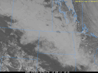
A nice break from the snow this week.. warming trend expected over weekend

Visible satellite image of eastern Prairies Mar 19 2013
showing extensive snowpack over MB, SK and ND.
Snowdepths are generally 50-75 cm across much
of the Assiniboine and Red River basins
After digging out from another 15 cm of snow to start the week, southern Manitobans will get a nice break from any more shovelling this week as high pressure dominates the weather pattern for the next few days with generally sunny skies but cold temperatures.  That will be welcome news as snow depths continue to increase across southern Manitoba including the Red River valley. As of this morning, snow depths across the region were generally in the 50-75 cm range, one of the deepest snowpacks in the valley since the spring of 1997.  Fortunately, no sudden thaw is forecast in the near future, with well below normal temperatures this week. A moderating trend is expected over the weekend into next week with temperatures climbing towards the freezing mark, but at this point, no major shift to an abnormally mild weather pattern is expected over the next couple of weeks. A sudden thaw of such a deep snowpack would increase the risk of significant spring flooding, particularly if accompanied by heavy rainfall.

Select snowdepths as of this morning (March 19) across southern MB and vicinity..

Winnipeg airport .................. 45 cm  (AWOS)
Winnipeg Charleswood ........ 58 cm  (COOLTAP)
Carman ................................ 69 cm  (COOLTAP)
Miami ................................... 57 cm  (COOLTAP)
Portage La Prairie ................. 71 cm  (COOLTAP)
Brandon A ............................ 77 cm (EC)
Pilot Mound .......................... 82 cm (AWOS)
Winkler ................................ 63 cm  (COOLTAP)
Morris ................................. 68 cm (COCORAHS)
Emerson ............................... 60 cm (COCORAHS)
Steinbach .............................. 57 cm  (COCORAHS)
Pinawa .................................. 55 cm  (COCORAHS)
Estevan SK ............................. 38 cm (EC)
Grand Forks .......................... 35 cm (NWS)
Fargo .................................... 50 cm (NWS) 

Sunday, March 17, 2013

Another winter storm to impact southern Manitoba today into Monday. Increasing winds Monday to give poor visibilities in blowing snow

Here we go again... another winter storm to test the patience and driving skills of winter weary Manitobans. This next storm system will be tracking from Montana through the Dakotas today into Monday, bringing another wave of snow to southern Manitoba.  Snow is expected to spread into SW Manitoba this morning moving into Winnipeg and the Red River valley this afternoon and evening. Snow is expected to intensify tonight with around 10 cm likely in Winnipeg by Monday morning, and 15 to 25 cm possible over portions of SW Manitoba and the Interlake regions where snowfall warnings are currently in place. As the system pushes east Monday, strong northerly winds gusting to 60 or 70 km/h on the backside of the storm will develop Monday morning, producing poor visibilities in blowing and drifting snow especially through the Red River valley. In fact, blizzard conditions are possible outside Winnipeg Monday morning into Monday afternoon. This will make for difficult travel conditions Monday for motorists.. so be advised to allow plenty of time to get to your destination Monday, or consider re-scheduling travel plans if possible especially if you're travelling outside the city. Consult MB highways website for updated information on highway conditions and closures.  Note that winter storm warnings have also been posted for much of North Dakota and NW Minnesota due to this storm system. This system will be clearing out of southern MB Monday evening, with dry but unseasonably cold weather for the balance of the week.

Stay on top of current conditions with Robs' Obs radar page, and webcam directory. In addition, get updated information on this storm system by clicking on "comments" section below..

UPDATE: Snowfall warning extended into Red River valley including Winnipeg. 10-15 cm of snow forecast tonight into Monday morning.

UPDATE: 9:20 pm Sunday:  Snowfall warning has been upgraded to BLIZZARD warning for southern and western RRV including Portage La Prairie, Carman, Morris, Morden, Emerson, and Steinbach. Blizzard conditions expected to develop Monday morning as strong northerly winds gusting to 60 km/h move in. Blizzard conditions expected to persist much of the day before improving from the west Monday evening. The strong winds and fresh snowfall will combine to produce considerable blowing and drifting snow on rural highways, and travel will likely not be recommended for areas outside the Perimeter, with local highway closures possible.      

Storm Totals as of Monday evening..

Winnipeg ............... 17 cm  (video from WFP)
Winnipeg Charleswood ... 16 cm
Brandon ................ 13 cm
Oakbank ................ 14 cm
Pinawa ................. 11 cm
Indian Bay ............. 12 cm
St Labre ............... 16 cm
Schanzenfield .......... 13 cm
Carman ................. 14 cm
Portage la Prairie...... 17 cm
Landmark ............... 17 cm
Steinbach .............. 14 cm
Ste Anne ............... 19 cm
Morris ................. 11 cm
Emerson ................ 14 cm
Morden ................. 11 cm

Friday, March 15, 2013

Weekend weather - sunny cold start with a snowy finish..

Oh no! Say it ain't snow!
GFS valid 7 pm Sunday March 17
showing storm system over Dakotas
bringing next snow threat to RRV
Winter continues to hang in tough over southern Manitoba and much of central Canada as a sprawling Arctic airmass spreads across the Prairies.  Temperatures will be running some 10-15 degrees below normal in southern MB this weekend, with highs remaining below the -10C mark and lows dropping into the minus 20s, temperatures more typical of mid January than mid March. (Normal highs in Winnipeg at this time of year are around 0C with lows of -11C).  Mainly sunny skies are expected Saturday with clear and cold conditions Saturday night as a ridge of high pressure builds into southern MB. On Sunday, skies will be clouding over ahead of yet another storm system that will be impacting southern Manitoba later Sunday into Monday. This storm system is forecast to track across Montana into North Dakota, bringing snow into Winnipeg and the Red River valley by late Sunday afternoon. Snow will continue Sunday night into Monday morning before tapering off by Monday afternoon. At this time, it looks like a general 5-15 cm of snow can be expected across southern Manitoba with this system, with the potential for locally higher amounts. Northerly winds will also be increasing on the backside of this system Monday, which will result in blowing and drifting snow.  This will make for a slow and tricky commute Monday morning with snow covered and slippery roads, so be prepared to allow extra time for your Monday morning routine.

6-10 day temperature outlook
valid March 21-25th 2013
showing no signs of spring
Colder weather will follow in the wake of this system with generally dry conditions much of next week.. although temperatures will remain well below normal.  Spring officially begins Wednesday March 20th.. but obviously, Mother nature didn't get the memo as the extended winter of 2012-13 continues well past its due date.  Note that Winnipeg has yet to climb above the freezing mark this month with a high of -1.1C on the 3rd.  If we don't get above freezing by the end of the month, it will mark the first time since 1899 that Winnipeg has failed to climb above freezing in March.   

Monday, March 11, 2013

Cold week ahead.. no hint of spring yet..

The weather this week will be pretty much what we've seen over the last little while.. generally below normal temperatures with occasional bouts of light snow. A weak system passing through tonight will bring a chance of some flurries, but little or no accumulation is expected. High pressure will build in Tuesday into Wednesday bringing generally fair but colder weather. Thursday will see increasing clouds ahead of a developing Alberta clipper system that will bring a threat of some snow to southern Manitoba by Friday.. with a few cm possible. A reinforcing shot of cold air will follow in the wake of this system for the weekend, with temperatures well below normal. At this point, no signs of springlike weather are seen for southern Manitoba through next week. This is in sharp contrast to the weather exactly one year ago this week when a historic March heat wave spread over southern Manitoba and much of eastern North America.  In Winnipeg, 7 daily record highs would be set over the next 9 days, including the all time warmest March temperature of 23.7C on the 19th. A 25 cm snowpack in Winnipeg on March 10th disappeared by the 13th with one of the earliest onsets of spring in southern MB history.

Tuesday, March 05, 2013

March 4th storm summary - Red River valley buried under heavy snow

A winter storm system tracking from southern Alberta into North Dakota brought an extensive swath of snow over the southern Prairies Sunday into early Tuesday.  In southern Manitoba, snow from this system spread over SW Manitoba Sunday evening, and became heavy at times overnight into Monday across much of southern Manitoba especially over the southern and western RRV. By Tuesday morning, impressive snowfall totals were recorded from this storm including..

March 4 storm snowfall accumulations
image credit: A Weather Moment

Miami ................. 56 cm
Carman ............... 42 cm
St Alphonse ........ 38 cm
Morris ................. 35 cm (est)
Morden/Winkler ... 33 cm
Emerson ............... 33 cm
Pilot Mound .......... 25-30 cm 
Brandon ................ 20-30 cm
Portage ................  24 cm
Winnipeg ............. 12-19 cm


In Winnipeg, general amounts of 15 cm were reported with up to 19 cm in the southwest part of the city (Charleswood)  The snowfall has added to an already impressive snowpack in the Red River valley, with snow depths now in the 50-65 cm range across much of the valley. This represents one of the deepest snow covers in the RRV since the spring of 1997, which preceded the valley's "Flood of the Century" that year.

Radar capture from 10 am Monday March 4th, showing an intense snowband that moved over Winnipeg between 930 am and 11 am. The band produced 5 cm in one hour at my location in Charleswood between 940 and 1040 am.  (see photo right taken at 10 am at my location) Snowfall ended after this band went through then picked up again in the afternoon through Monday night. I picked up 11 cm by Monday evening, with another 8 cm Monday night for a storm total of 19 cm.  

Sunday, March 03, 2013

Snow spreading into southwest MB this evening.. arriving in Winnipeg towards midnight

A slow moving low pressure system over southwest Saskatchewan is bringing an extensive area of snow across the southern Prairies from the Rockies into southeast SK. This area of snow will be spreading across SW Manitoba this evening and into the Red River valley through the evening and into midnight. Snow will become heavy at times overnight and into early Monday, with 10-15 cm of snow possible by Monday morning south and west of Winnipeg. Snow will continue Monday across southern MB before tapering off Monday night into early Tuesday.  Snowfall warnings are in effect for all areas south and west of Winnipeg including Brandon, Portage La Prairie, Carman, Morden, Morris, Emerson, and Steinbach where storm totals of 15 to 25 cm are possible by Tuesday morning.

For Winnipeg, snow is expected to move in by midnight and increase in intensity overnight. About 2-5 cm of snow is possible by the morning commute, so give yourself extra time for the drive in Monday morning. Roads will be getting snow-covered and slippery, especially outside the city. Snow will continue Monday, moderate to heavy at times, with another 5-10 cm likely by the evening commute. So expect a slow commute home as well. Snow will begin to taper off Monday night into Tuesday morning, with another 2 to 5 cm possible before it ends. Storm snowfall totals of 10-15 cm are possible for Winnipeg between midnight tonight and Tuesday morning, with a risk of higher amounts if we get some stronger bands setting up over us. Snowfall warnings may be expanded to include Winnipeg if the storm tracks a little further north than currently forecast. Stay tuned on this developing winter storm system..   (Note: Winnipeg was added to snowfall warning on 5 am Monday morning update)

Keep track of snow spreading into southern MB using Radar Viewer from A Weather Moment.  Consult the MB Highways website for updated information on highway conditions over southern MB. Note also that winter storm warnings are in effect for North Dakota as well, where 20-30 cm is forecast south of the border, including Grand Forks.  

Saturday, March 02, 2013

Winter storm system to impact southern MB Monday. Heaviest snow expected mainly south and west of Winnipeg

NAM prog valid 9 am Mon Mar 4
Low over North Dakota is
forecast to spread snow over
much of  southern MB and RRV
A storm system developing over southern Alberta is forecast to track into North Dakota Sunday bringing a swath of significant snowfall across much of southern Saskatchewan, North Dakota and portions of southern Manitoba.. especially to the south and west of Winnipeg.  A general 10-30 cm is forecast from southern Saskatchewan into North Dakota Sunday afternoon into Monday night, where winter storm warnings are now in effect. It looks like this system will also be bringing snow to southern MB, with the highest amounts expected over southwest MB and the southern RRV (including Emerson). Things become a little less clear as to how far north and east the snow from this system will spread, with varying opinions about how much snow will fall in Winnipeg. Some models are suggesting snow will get into the city with 10-15 cm or more possible Monday. Other models are saying the system will graze us, with minimal snowfall forecast. At this point, it looks like Winnipeg will be seeing some snow overnight Sunday through Monday with 5-10 cm possible, with greater amounts likely south of the city. However, this is still a developing system, and a slightly more northerly track will push heavier amounts of snow into Winnipeg, while a more southerly track will keep the snow mainly out of the city. Stay tuned on this storm system, and we'll keep you posted right here on any trends or changes as the system draws nearer. One thing's for sure.. if you have travel plans west or south of Winnipeg into North Dakota or western MB/eastern Saskatchewan late Sunday or Monday, be prepared for poor travelling conditions with snowcovered roads and poor visibility at times.

UPDATE: (11 am Sunday):  Snowfall warnings have been issued for SW Manitoba and southern RRV from Virden/Brandon areas to Morden/Emerson region. 10-25 cm forecast tonight through Monday. Warning area may be expanded northeast towards Winnipeg based on latest storm track and model guidance. Stay tuned for updated forecasts and warnings.   

Update: (330 pm Sunday) Snowfall warnings have been expanded to include areas from the Riding Mountains through St Rose, Gladstone, Portage, Carman, into Steinbach. 15-25 cm of snow possible tonight through Monday into early Tuesday.  Winnipeg currently NOT in the snowfall warning, but we will be getting snow, and it's possible the warnings may be extended further into the city.  Stay tuned for updated forecasts and warnings. (Winnipeg added to snowfall warning on 4:30 am Monday update)

NAM vs GEM re: snowfall projections over next 48 hours
(based on Saturday night model runs)


48 hr snowfall - NAM
valid 00z Sun - 00z Tue
green line is 7.5 cm
yellow line is 20 cm
48 hr snowfall - GEM
valid 00z Sun - 00z Tue

green line is 7.5 cm
yellow line is 20 cm