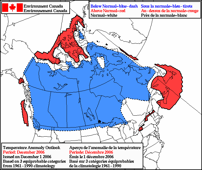

Quite the opposing views on what kind of December we'll have according to the latest 30 day outlooks from Canada (EC) and the US (CPC). According to EC, temperatures across Manitoba, and much of Canada, are forecast to be below normal this December (top image) In contrast, CPC is forecasting a better than even chance of above normal temperatures this December over the eastern Prairies(bottom image)
Who's right? Maybe neither.. It could end up somewhere in between. Correlations with past weak El Nino years suggest that December and January are generally milder than normal here in Manitoba.. but that's not always the case. So I guess we'll just have to wait and see.. and cross our fingers that the Americans are right!
I am interested in understanding why there is such a discrepancy between your current temperatures that include windchill and Environment Canada's calculations. I note your published temperatures are significantly warmer than any other source of weather information for Winnipeg, and have concerns because apparently this information is being used by an entire school division to determine whether children should be outside or not.
ReplyDeleteAs noted on my website.. data from my weather station is unofficial and should only be used for general interest. My weather station data (taken by a Davis Vantage Pro station) is fairly reliable, however, my wind measurements are quite a bit less than exposed areas (such as the airport) The reason for this is that my wind sensor is only 15 feet up, and sheltered by trees and houses so wind measurements at my site will be a lot lower than EC's site at Winnipeg aiport which is totally exposed, and has a sensor 30 feet up. As a result, my wind chill measurements will always be significantly warmer than the airport and other sites that have better wind exposure. For more details on accuracy of my weather station data, see "Station Info" under MISC drop down menu.
ReplyDeleteFor more accurate wind chill readings in Charleswood, I would use the Pacific Junction school weather station which has a better exposed location on top of the roof for more accurate wind readings. This was the reason PJ got their weather station in the first place.. for more reliable wind chill readings at their specific location.
So to clarify, would this mean that wind chill readings at Pacific Junction school would not necessary be correct for another school 3 kms away with a huge open field for a playground?
ReplyDeleteGenerally, wind chill readings from PJ should be representative for the average school yard in Winnipeg. However, schools in exposed areas of the city with very little in the way of trees or buildings will usually be windier, and thus will have colder wind chill readings. School yards that are more sheltered by trees and buildings will likely be less windy (and have "warmer" wind chill values)
ReplyDeleteThe problem is that official wind chill readings from EC are from Winnipeg airport, which is in a very wide open exposed area. Often, winds from the airport site are stronger than anywhere else in the city. Thus, the wind chills quoted from EC are generally the "worst case" readings you would expect in the city. That's why some schools (like PJ) have installed their own weather stations, to better monitor wind chill values that are more representative for their own location.
Bottom line.. look at PJ wind chill values as a good indicator of wind chills for the average school yard in Winnipeg, and look at Winnipeg airport as the "worst case" scenario. If your school yard is exposed as much as the airport, then the airport will likely be a better guage for wind chills.
Hope that helps!