 |
| NAM model showing position of Colorado low at 6 pm Friday eve. Swath of heavy snow and strong winds will be bringing blizzard conditions to Winnipeg late Fri |
Before the main event, a cold front pushing through southern MB tonight will usher in colder air from the north with some snow or freezing drizzle developing overnight. Snow will continue through the day Friday before it starts intensifying in the afternoon and evening. Snow will become heavy at times, and with strong northerly winds gusting to 70 km/h, blizzard conditions are expected Friday night into Saturday morning, especially outside the city. At this point, it appears that Winnipeg will see about 10-20 cm total snowfall by Saturday morning with this storm, with higher amounts possible outside the city. The snow however will not be the main story, as the strong winds will result in heavy drifting and blowing snow, along with poor visibilities. The western RRV between Winnipeg and Portage will be especially bad given the full fetch of strong NNW winds off Lake Manitoba. Conditions are expected to improve by Saturday afternoon as the storm system tracks into NW Ontario.
Blizzard warnings are issued by Environment Canada for storms that will bring at least 4 consecutive hours of visibilities of 1/4 mile (400 metres) or less in snow and/or blowing snow, along with sustained winds of 40 km/h or more. Specific thresholds of snowfall are not required for blizzard warnings, as they are based on visibility criteria, not snowfall amounts.
Follow the storm on radar! Click on radar viewer from A Weather Moment to follow progress of snow as it heads into southern Manitoba.
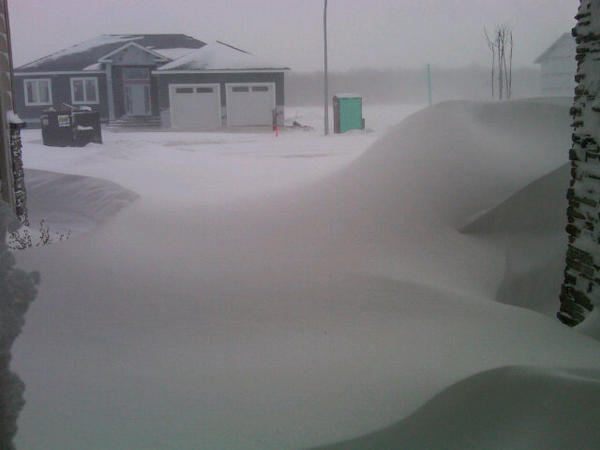 |
| An example of the heavy drifting near Winnipeg caused by Friday's blizzard. Winds gusting to 75 kmh and 10-15 cm snow produced extensive blowing and drifting snow |
Photo tweeted by @loco372
Cold frontal trough literally along Hwy 75 this evening. -5C west of 75, +3C east. Front slipped through Winnipeg late afternoon as winds shifted into north from south, temp dropped from +2C to -2C in one hour.
ReplyDeleteSnow has pushed into western MB and interlake regions this evening. Expect snow to sink southward overnight as cold air pushes south.
The Canadian warmspot today was Fort Frances, Ontario at 8.3C.
ReplyDeleteThose winds from the north are howling pretty strong already
ReplyDeleteLight rain since midnight +1 and no wind in the South Whiteshell
ReplyDeleteHmm models have pushed the system further east today.
ReplyDeleteThis storm hasn't even hit us yet and WN is calling for 10-15cm on Tuesday. Exciting!!
ReplyDeleteHearing reports of widespread freezing drizzle and rain overnight, causing icy roads and many accidents. EC called it, with %100 chance freezing drizzle overnight, but CBC told me at supper yesterday that the chances were slim and only in the southeast. Perhaps when it comes to matters of public safety, they should leave it to the experts.
ReplyDeleteYes, that freezing drizzle was quite extensive in Winnipeg and throughout the RRV overnight. Left a good coating of ice on everything, including webcams! Even getting some power bumps this morning from the effects of the icing and wind.
ReplyDeleteLooks like it's turning over to snow now in the city, with poor vsbys in light snow and blowing snow. Things still on track for heaviest snow tonight as Colorado low tracks to our southeast. Overnight model runs have backed off a bit on the snow amounts for Winnipeg, with 10-15 cm for us, more to our south and east. However, even with that amount of snow, should be plenty to blow around and give poor vsbys tonight into early Saturday.
Hi Rob,
ReplyDeleteI'm hearing of another possible snowstorm on Tuesday with much warmer temps.
What are your thoughts on that situation?
I bet the heavy snow misses us and we only get 5 cm. If it wasn't for the winds this would become a non event. How depressing.
ReplyDeleteIf you were expecting a massive blizzard with 30+ cm, then yeah, this storm may be a disappointment. But I think we'll still see a period of good snow tonight, and together with those winds, we should get some pretty low vsbys. I'm surprised vsbys are as low as they are right now with just some light snow falling (and blowing). Things should get worse tonight with the snow intensities picking up and winds peaking.
ReplyDeleteAs for snow amounts, latest GEM has tracked the storm further east which would put the heavier snow east of Winnipeg, but I'm not sure I'm buying that solution given the strength of the low developing in Colorado, and the upper pattern. Prefer the NAM which shows a track a little further west, bringing 10-15 cm of snow to Winnipeg later today through tonight.
Rob, the last colorado low that affected us back on November 10th brought us 20-30CM. What's the difference this time around with this colorado which is only gonna give us a marginal 10-15CM?
ReplyDeleteLet's face it, if it weren't for the wind this would not be a big storm by any stretch. This likely means that this colorado low does not necessarily have an abundance of moisture to work with.
Rob,
ReplyDeleteI've noticed that more snow is expected Tuesday. Not so sure about that plus 1 forecast high though.
Does this look like another potential storm?
12C with a dewpoint of 10.4C in Windsor, Ontario right now.
ReplyDeleteMost humid day of 2013 so far (in Canada).
Heavy snow right now in Altona.
ReplyDeleteTuesday's system is an Alberta clipper tracking through southern MB. GEM is by far the farthest north on it and looks unlikely given the extent of the cold air in place. Would expect a track further southwest of us, so that advertised high of +1C is highly unlikely. Perhaps 5 cm of snow for us Tuesday with a highs moderating to around -8C, then back into deep freeze behind it.
ReplyDeleteRob, this may be too difficult to pinpoint but if you had to venture a guess based on latest at what time this evening would you expect the heavy snow and the blizzard's arrival in the RRV and Winnipeg?
ReplyDeleteHm models certainly not going for a massive storm right now. Many say 5-10 cm. But who knows, sometimes we can get lots more than expected with Colorado Lows (Dec 2006 always comes to mind)
ReplyDeleteWell, EC still going with 10 to 15 CM tonight but I agree not sure we will even get that much at least right now but you never know....Mother Nature does sometimes like to surprise us. Right now this really does look like more a wind event rather than snow. Not much on radar at least on the Manitoba side right now other than band of moderate snow west of Brandon.
ReplyDeleteAnd also some light snowfall east and southeast of Winnipeg.
ReplyDeleteRadar filling in nicely to the south and east of Winnipeg, and should continue to intensify through this evening, including Winnipeg. Highest accums expected mainly south and east of the city, but we should still be in line for 10 cm or so I would think. Again, it's the wind that will cause most of the problems, especially with visibility which has been poor all day even without much snow falling.
ReplyDeleteFor a colorado low, 10 CM is sure not a lot of snowfall. Without the wind this wouldn't even be much of a storm. But like some have noted we have been surprised in the past from these colorado lows, so anything is possible but we'll see.
ReplyDeleteHey Rob, Does the storm system in the west portion of manitoba pose more of a threat then the colorodo low?
ReplyDeleteBeen noticing the snow lying just south and east of Winnipeg over past hour or so but it's almost like there is a shield right now preventing the snow from moving into the city....hmm.
ReplyDeleteWinds really picking up at this hour. Gusting to 74 km/h at YWG Airport reducing visibilities again.
ReplyDeleteLooks like we are a matter of perhaps a half hour from the beginnings of the real deal. Gonna get horrible out there soon.
I'm at McPhillips/Perimeter area and those wind gusts are all of 74 kmh. I would not be surprised if they were 80 or more. The entire house is just shaking.
ReplyDeleteYeah, those wind are really howling now.. and should be strong all night into early Saturday. Visibilities inside the city still not too bad, but anything near and outside the Perimeter will be getting blasted, especially as this area of snow pushes into the city this evening.
ReplyDeleteVisibility at the airport dropped to 1/4 mile at 00Z (6 pm) in snow and blowing snow which is official criteria for a blizzard, as long as it lasts for at least 4 hours.
1.. In answer to your question, no that band of snow over western MB will not be impacting us here in Winnipeg. The bulk of the snow for us will be on the western flank of the system tracking into Minnesota.
73 responses to the snow poll.. most popular pick was 15-20 cm by a 2:1 margin. Next was 10-15 cm. "Ensemble" snow poll average was 15.2 cm.
ReplyDeleteTough part will trying to measure the snow that actually falls!
Hey Rob
ReplyDeleteWhats going to happen when the two snow systems merge. Will they start a counter rotation like so many Colorado lows do?
We'll have to see where the main snow band and frontogenesis sets up.. at this point it still looks like areas south and east of Winnipeg, although SE suburbs may be grazed. Models initialized a bit too far north with this feature. If the band does stall out to our south, we are probably looking at several hours of lighter to moderate snowfall rates (0.5 to 1 cm/hr) until around 3 am, when band is progged to weaken and shift NE. That would give totals roughly around 5-7 cm (given lower snow-water ratios from strong wind). 10-15 cm amounts would occur under the strongest forcing off to our SE under that scenario.
ReplyDeleteNorthern band is expected to weaken as Rob mentioned, with dry air moving south (Td's of -18 to -20 C lurking over northern interlake).
Daniel
Daryl..
ReplyDeleteLooks like that western band will just get absorbed by the Colorado low precip shield..
Radar shows snow increasing over the city now.. with heavier banding south and east of the city, especially from Emerson to Falcon Lake.
One thing is for sure, if it weren't for the wind this wouldn't much of a storm.
ReplyDeleteAt least for Winnipeg anyway
ReplyDeleteReally starting to worsen in the past half hour here in the south end; can't speak for the rest of the city. Visibility getting quite reduced within city limits here now. Even heavier returns on the radar approaching the city from the south so it's only going to get worse.
ReplyDeleteyeah starting to look that way. pretty reduced visibilities here in Windsor Park also at this hour.
ReplyDeleteColorado lows have sometimes surprised us in the past, so we just never know...we could get more snow than it seems right now....we'll have to wait and see on that.
ReplyDeleteJust took a drive around Southwest Winnipeg. Visibility is not too bad in Charleswood but as soon as I hit the perimeter it's almost white out conditions and you can hardly see the road. Not a good night to be traveling especially outside the city. Highway one now closed from Winnipeg to the Saskatchewan border.
ReplyDeleteRob what is your take on the storm do you think it is going to be what was expected or will it produce lighter amounts of snow. Is the system still expected to leave in the early morning with the winds dying down around noon?
ReplyDeleteWN says close to 5 cm of snow from Friday Overnight to Saturday Overnight.
ReplyDeletedisappointing blizzard event.
ReplyDeleteJust kidding...
went for a 20min walk her in Rivergrove to experience a blizzard. Down wind heading south is no prob. Stretch home more challenging!
regardless of the snow amount... quite a storm. wind is howling. Wouldn't want to be out there too long.
challenge all to take a quick walk and get a little face time with a prairie blizzard.
Going to settle down now with the HD tv, warm blanket, and a nice scotch.
thanks Rob for the great resources! you make observing and anticipating the prairie weather so much more enjoyable!
Daryl.. The storm is behaving pretty much as expected. Snow has come in this evening on schedule, and we're now getting very poor vsbys with blizzard conditions. Snowfall amounts will be misleading to give, since the wind is producing such heavy drifting. I've received about 5 cm on my driveway, but I've seen drifts 2-3X that on roads and in parking lots. I still expect total snowfall of around 10-15 cm or so in Winnipeg, but drifts will be 20-30 cm while other areas will be swept bare. The winds are really blowing and drifting the snow around, and winds will be quite strong (G60-70 km/h) through 3 am or so then easing a bit overnight into Saturday morning. Winds continue to drop off after noon Saturday.
ReplyDeleteZero visability near dominion city, frightening to drive and highways here still ice covered from the freezing rain. Lots of snow so far, maybe 10 cm where it's sheltered on the farm, I am expecting big drifts around the gates. Guess we will see in the morning, but I would advise not to take to any highway until the wind has passed us.
ReplyDeleteYeah almost impossible to guess how much snow has fallen. RADAR estimating 2-3 mm of water equivalent so far for the city.. with 8-12 mm running from Emerson to Marchand under that mesoscale band. Precip has now evolved into a broad area of moderate snow. RAP still shows band starting to weaken and shift east between 1-3 AM. Probably would end up being 5-7 mm water equivalent under that scenario - but snow-water ratios seem to be higher than 10:1, so sheltered areas could end up with 10 cm. Most open areas will just be stripped down almost to the old snowpack as mentioned.
ReplyDeleteDaniel
Daniel, would you agree that EC's forecast of plus 1 Tuesday is totally off the mark and how much snowfall can we expect from Tuesday's Clipper system?
ReplyDeleteWindsor, Ontario went up to 14.0C. That's the warmest temperature this year in Canada.
ReplyDeleteTheir dewpoint of 10.6C was also the highest recorded this year in the country.
No power at my place in Charleswood since 4 am.. Hope MB Hydro fixes problem soon.. getting a bit cold here!
ReplyDeletePower back on as of 6:40 am.. thank you MB Hydro!
ReplyDeleteCoCoRaHS observer in Morden reports 2.9 inches of new snow, and 3.5 inches of melted water equivalent. Perhaps there's a heavy water reactor nearby? LOL
ReplyDeleteCoCoRaHS observer in Winnipeg reports 3.5 inches of new snow and 0.57 inches from a melted snow core. Gives a SLR of 6.1:1. That normally would indicate a very heavy, wet snow...but perhaps in this case the result of a windblown hardpack snow.
ReplyDeleteVery tough to get an accurate snow measurement because of the drifting, but I measured variable depths between 8 and 18 cm at my place. I'm calling it 13 cm (5 inches) as an average which is line with the 10 mm water equivalent the airport recorded. Deeper drifts of 25-30 cm common. Hard packed snow because of the strong winds makes it that much more difficult to shovel.. will be needing the snowblower to get through the driveway drifts today.
ReplyDeleteMorris observer reports 9.0 inches (23cm) of new snow. Morris reports 7.4 inches (19cm).
ReplyDeleteWoops. Morris 23cm, Steinbach 19cm.
ReplyDeleteGot drifts reaching as high as 3/4 of a metre in my yard in south end.. There's a field just north of my place which helped.
ReplyDeleteJJ
14.2C in St. Catharines (Niagara) right now!!!
ReplyDeletePretty mild out east.
Drifts on my driveway in La Salle are 28" and packed like concrete. Got a lot of snowblowing to do.
ReplyDeleteDriveway is 75 ft by 25 ft.
I'd rather be here with this blizzard than out east with the teen temperatures :) Those temperatures can wait for Spring.
ReplyDelete^like. We need more people with attitudes like that!
ReplyDelete15c in St Catharines now. Growing up in Niagara in the 70s, it was unheard of for us to hit double digits in the winter. Now they seem to be doing it every winter, and more than once as well. Winters down there sure aren't what they used to be!
ReplyDeleteSnow poll honours go the 17 people who picked 10-15 cm.. well done! Poll ensemble average was 15 cm.
ReplyDeleteOh wow ended up pretty accurate then!
ReplyDeleteRadar estimates around 6-8 mm water equivalent over the past 24 hours across the city with 8-12 to the southeast. Rob, the 10 mm at YWG was since last evening or included the freezing precip from earlier?
ReplyDeleteDaniel
Daniel.. YWG recorded 9.5 mm from midnight to midnight yesterday, so that amount would have included the freezing drizzle in the early morning hours (about 0.5 mm of ZL?)
ReplyDeleteIC thanks.. yeah maybe .5 to 1 mm freezing rain with also some snow in the morning as well. So it could fall within the doppler estimated range of 7-8 mm. With higher snow-water ratios (maybe 14:1/15:1) it would have yielded 10-13 cm for the city.
ReplyDeleteDaniel
Will be interesting to see if YWG drops to the -30c mark tonight which would be our first -30c reading in almost 2 years (last time was -31.6c on Feb 25 2011)
ReplyDeleteBoth the NAM and Euro giving sub -30C lows for YWG tonight, while official forecast based on GEM UMOS is giving -27c. I think -30c would be a slam dunk if YWG kept a light NW flow all night with clear skies and a fresh snowpack, but flow backs to light southwest overnight which may prevent airport from reaching the -30c mark. Maybe another -29c? Regardless, cold night ahead.
Got about 7 to 18cm of snow at my place in St.James last night, with 25cm+ in snow drifts. Definitely a non significant snowfall that's for sure. I had no power outages which is odd because Rob just over on the other side of portage had no power whatsoever, anyone know why that could be the case?
ReplyDeleteMike.. The power outage was pretty local, looked like just my street was affected. Didn't appear widespread.
ReplyDeleteIt wasn't a non event if you were travelling.
ReplyDelete
ReplyDeleteI've noticed EC has dropped Tuesday's high to - 8C from the plus 1 yesterday which to me is more realistic. Note that they also changed the forecast from snow to sunny....hmm.
Rob, What's the latest on Tuesday's situation as far as potential snow snow is concerned?
A non-event in a Winnipeg residential area. Perimeter-itis it's called.
ReplyDeleteAnonymous.. Models are showing an area of snow with Tuesday clipper moving across southern MB Tuesday afternoon into Tuesday night. Looks like about a 5 cm type of event. That forecast change from snow to sunny is an automated forecast overlooking a nighttime precip event (forecast is based mainly on daytime hours). Looks like we moderate to around the -5C mark, but it will likely be Tuesday night so most people won't notice it. Back to the deep freeze behind the clipper.
ReplyDeleteRob, how cold does it get behind the clipper system and what does the second half of January have in-store for us in terms of temps and precip?
ReplyDeleteBTW, thanks for all the great info you provide us, Rob...greatly appreciated. I'm a big fan of your blog. Thanks for taking the time to update us on your blog about upcoming weather info we wouldn't get anywhere else.
anonymous.. Looks like we'll be back into the -teens and -20s behind this next clipper with -30s possible at night. As for what the latter half of January will be like, that's getting beyond my expertise, but I can give some basic background info based on my limited knowledge in this area. Models are indicating that the upper pattern should favour colder than normal weather over central and eastern North America by mid to late January as a deep Arctic trof digs over the Great Lakes, with an upper ridge building over the West Coast. That is consistent with a weakening AO signal. That will put us in a NW upper flow which generally means colder than normal weather, with periodic modification as clippers come through in the NW flow. That's how it looks right now.. we'll have to see if models maintain that scenario, or flip to something different.
ReplyDeleteOnly -26C at the airport?! Odd. I live a block away and my thermometer shows -31C.
ReplyDeleteOvernight, it seems like temperatures dropped down a bit more to the north, as well as to the south and east of the city... -31 at Sprague, -33 at Gimli, and -34 at Pinawa according to Environment Canada. I'm wondering if the slightly lighter winds (<10 km/h) would be the main reason that pushed these areas into the -30s?
ReplyDeleteYeah, plenty of -30C temps north and east of the city last night, but the YWG airport was saved with a light southerly flow off the city. I got down to -29C at my place as a light southerly flow overnight would come off the open fields south of Charleswood.
ReplyDeleteSo the above -30C streak continues at YWG airport. For those keeping track, the streak is now at 687 days and counting, going back to Feb 26 2011 (YWG last hit -30C or lower on Feb 25 2011 at -31.6C) That's the longest such streak ever at the airport site since records began in 1938. The longest streak ever in the city was 713 days between Feb 15 1930 and Jan 30 1932, but that was at the old St John's College observing site closer to downtown.
Meanwhile, it's an incredible 16-18C in Niagara this morning!
ReplyDeleteHmmm. I live a block south of the airport and my thermometer was 5C colder. I'm thinking it had more to do with cold air trapped in my yard, the tree/houses preventing mixing with the warmer air aloft.
ReplyDeleteYeah, there would certainly be pockets of colder air in the city that would have been blocked from the light wind, and radiated colder.
ReplyDeleteRob,
ReplyDeletedo you think that the above -30C streak at YWG Airport will end tonight?
My goodness and dewpoint of 13°C there Rob. Seems like a nice summer start to the morning. Dewpoints that high and we're starting to enter thunderstorm territory.
ReplyDeleteAnonymous.. -30C doesn't look likely for YWG tonight due to a little more cloud cover, and again a light southerly flow overnight that will prevent the temp at YWG from bottoming out. Most guidance is indicating lows of around -25C for YWG tonight. Could be a couple degrees colder if skies clear.
ReplyDelete