
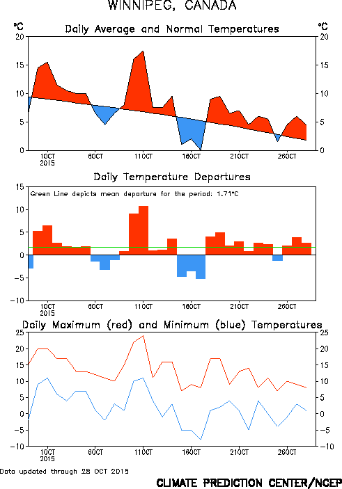
Map of temperature anomalies (left) showing widespread warmth in October over western North America. 30 day temperature graph for Winnipeg (right) showing dominance of above normal temperatures during October.
Weather outlook for November 2015
According to NOAA, the mild weather pattern is expected to continue through much of November across the Prairies, with generally above normal temperatures over the next 2-4 weeks. (see maps below) This doesn't mean warm weather every day, but generally a greater frequency of above normal temperatures during the next month.


CPC temperature outlooks maps for early and late November
(8-14 day outlook left, and 3-4 week outlook right)
(8-14 day outlook left, and 3-4 week outlook right)
The mild pattern appears to be in response to a very strong El Nino that has developed over the Pacific this year, and is currently on track to be one of the strongest El Nino episodes recorded since reliable records began in 1950. As of October, the 3 month averaged El Nino index was at +1.5 and expected to climb to +2 or higher by December, the strongest El Nino since 1997, regarded as the strongest El Nino event since 1950.
Backgrounder: 2015 El Nino


Top: Graph of Oceanic Nino Index since 1950 showing strongest ENSO events
Lower: Graph of this year's El Nino ocean temperature anomalies expected to peak by December
Lower: Graph of this year's El Nino ocean temperature anomalies expected to peak by December
Note that Winnipeg had its second warmest winter on record in 1997-98, thanks to the unusually strong El Nino that year. That winter saw very little snow through December, with only a trace of snow on the ground in Winnipeg on Christmas day. The winter finished with an average temperature of -8.2C, a whopping 6C above normal, and the second warmest winter on record in Winnipeg, second only to that of the incredibly mild winter of 1877-78 (another very strong El Nino year)

 | |
| NOAA winter outlook for Dec 2015-Feb 2016 showing greater odds for drier and warmer than normal winter over Prairies |
Will El Nino bring mild weather for Grey Cup? (Nov 29 2015 in Winnipeg)

So it appears that milder than normal conditions are favoured for the Grey Cup this year. If so, it would be the third consecutive time that Winnipeg has hosted the Grey Cup with mild weather (along with 2006 and 1998). But as any sports fan will tell you, underdogs can always win a game. So although mild weather is the odds on favourite this year, it only takes one storm system to bring in an untimely shot of snow and cold weather to southern Manitoba at the end of November, even during an El Nino year. This year's strong El Nino would lower the odds of that happening, but you can't rule it out completely. So let's hope the mightly forces of the El Nino Zephyrs from the west prove too strong for the punishing attack of the Arctic Express from the north. Go team El Nino!!

EXTREMES FOR NOV 29 USING PRE-AIRPORT CITY DATA BACK TO 1872
RECORD HIGH: + 7.2C (1932)
RECORD LOW: -36.7C (1875)
NOV 19 2006 ........Clear. High + 1.5C, low -9.2C. Kickoff temp: -3C
NOV 22 1998 ....... Sunny. High + 9.7C, low: 0.6C. Kickoff temp: +5C. Record mild day!
NOV 24 1991 ....... Sunny. High - 15.6C, low: -21.9C. Kickoff temp: -16C
WEATHER FACTORS THIS YEAR:
- Very strong El Nino pattern favours milder than normal conditions for late November
- 55% chance of highs > -4C on game day, 25% chance of highs < -7C
Personally, I would love to see a green Christmas this year.. no snow until after Christmas would be fine by me! And then all gone by the end of February! :)
ReplyDeleteI see plenty of cold, below normal air in Northern Nunavut now.It's just a matter of keeping it up there.
DeleteDull mild weather continues over Winnipeg/RRV. Today (Nov 2nd) is Winnipeg's 7th straight day with temperatures remaining above freezing, even at night. Pretty impressive considering our normal low now is -5C. Looks like another couple of days with clouds and temps staying above freezing before hopefully some sun by Thursday.
ReplyDeleteThis would be very consistent with an El Nino type winter.. lots of cloud, misty, occasional drizzle, freezing drizzle or light snow, and very mild temperatures for extended periods.
Hey Rob,
ReplyDeleteI see accurate weather is calling for 20 cm on Nov 19th.
I know it is a long term forecast but I'm hoping it happens!!
Obviously as we closer to the date you would provide an update.
Certainly would give us something to talk about.
Rob whats your take on the snow they are forecasting today?
DeleteLooks like we're just staying mainly as rain here in Winnipeg/RRV, although we may see some wet flakes this afternoon into this evening. Better chance of some accumulating snow east of us through Whiteshell/Sprague regions through this evening.. perhaps 2- 5cm..
DeleteNice to finally see that sun again.. first time here since Oct 30th, and only our second day of sun in the past 12 days. Temps today will peak around +5C with a brisk southerly wind. Sunshine continues Sunday with temps climbing to 10-12C, and lighter winds than today. Beautiful day to cap off the weekend as our glorious fall continues!
ReplyDeleteI'm looking at our exceptionally mild start to November, and although it's been quite mild, it may not even make the top 5 mildest first halfs of November. Our average through Nov 15th will be around +3C, which is well above normal.. but we've had milder first halfs of November. The top one is 1981, with a phenomenal average of +4.9C through the first 15 days, including 10 days of +10C or more (only 2 so far this year) 1999 was another mild one, averaging +3.5C through the first half of the month (and 8 days of +10C or more). What has made this month so mild has been the mild nights more than the mild days.. thanks to frequent low cloud cover and a lack of arctic airmass intrusions. If we can continue this pattern though the end of the month (which appears to be the case), we have a good shot at finishing with a top 5 mild November.
ReplyDeleteGetting a little more model consensus that we may be seeing our first shot of colder than normal temps this month later next week (after Nov 18th) Big upper trof swings through the Prairies with colder air, while big upper ridge pumps up unseasonable warmth over eastern Canada/US. But it also looks dry with that colder weather, so we may not see much snow.. unless we get some next Wednesday with the cold front. Hints that the cold weather will be short lived as heights rise and temps moderate again by the 22nd or 23rd.
ReplyDeleteWN calling for snow!!!!
Delete1963 November memories: seemed to cool rapidly after the sizzling October but everything turned cold after JFKs assassination on the 22nd. Started off as a pleasant day in Camp Shilo where I was stationed. Sunny my day off Friday . Left camp early aft but it was cold when I reached Portage La Prairie.. Memory says it remained cold after that.. Suspect the reality was a bit different but the Great October weather and the JFK day stand out.
ReplyDeleteThanks for the recollection Don.. that fall of 1963 was something else, easily the warmest fall on record in southern MB and much of central North America. I see that the Winnipeg woke up to its first snowfall of the season the morning of the 22nd with about 6 cm of fresh snow. By 12:30 pm however, no one would be talking about the snow..
DeleteRob what are your thoughts on snow this week?
ReplyDeleteGiudance coming into line for a definite pattern change to colder weather by Thursday as a strong cold front pushes through Wed aftn or Wed night. Strong NW winds will usher in much colder air for Thursday into the weekend with temps staying well below freezing through the period. How mcuh snow we'll get is still uncertain. It appears we'll see some with the cold front later Wednesday into Wed night, and then possibly some wrap around snow i the colder air. We could see our first coating of snow here on Thursday morning. We may also see some lake effect flurries Thursday, but Winnipeg usually misses out on that unless we get a favourable 300 wind off Lake Manitoba. So jury still out on how much snow Winnipeg will get.. but initial guess is that Winnipeg could see 2-5 cm through Thursday.
Delete