 |
| MODIS satellite image of MB lakes Saturday Nov 8 2014 |
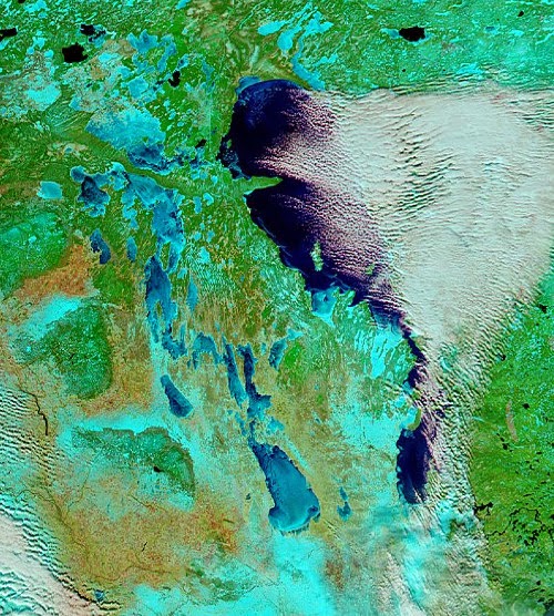 |
| MODIS satellite image of MB lakes Thursday Nov 13 2014 |
Well below freezing temperatures over the past week has brought the first snows of the season over much of southern MB as well as a rapid freeze up of the Manitoba lakes. The two "false colour" MODIS satellite images above were taken just five days apart between Nov 8th (left) and Nov 13th (right) The images show a much different landscape over southern MB over that time with more extensive snow cover (shown in light blue) and a rapid freeze up of the western MB lakes, with Lake Manitoba and Lake Winnipegosis now mainly ice covered. Lake Winnipeg still remains generally ice free except along the shores and some bays.. which is allowing lake effect cloud and flurries to persist as cold winds blow over the open water (open water seen as dark blue on satellite imagery with clouds seen in white) In fact, you can see the bands of heavier lake effect snow over the past day or two immediately south of Lake Winnipeg and Lake Manitoba, with less snow cover elsewhere over southern MB (bare land shows up as light brown)
With a continuation of well below freezing weather over the next 5 to 10 days, ice cover will continue to grow rapidly on the lakes, with Lake Winnipeg likely freezing up by the middle to end of next week. This will effectively shut off the lake effect machine for the season, and will also allow invasions of cold air to spread into southern Manitoba unmoderated by the lakes. Like it or not, winter is here folks!
Hey Rob, possible snow storm Sunday & Monday?
ReplyDeleteNot all models are on board with it, but GLB and GFS do show clipper crossing southern Manitoba and intensifying as it moves to our east.. with perhaps 5-10 cm for us by Monday. Euro further south and east with it with less snow. We'll see how things trend over the next few days but it bears watching.
Delete2 cm of light fluffy snow this evening in SW Winnipeg. After seeing the scenes from south Buffalo today, I'm embarrassed to report that.. :)
ReplyDeletedoes Winnipeg have "official" snowcover now? I always remember in the spring they will give the official length of snowcover to snowmelt.
ReplyDeletemagnolia.. Well, sort of. Official snowfall observations at Winnipeg airport stopped around 2005, ending a historical record of snowfall from our main observing site that started in 1872. The automated airport weather station now has a sonic snow sensor that measures snowdepth using sound waves, but it can be prone to errors as well as having problems with blowing and drifting snow. A human observer is still the best way of making accurate snowfall observations. I take snowfall measurements for Winnipeg from my home in Charleswood, and enter them every day in the EC climate archives as official snowfall readings, including daily snowfall and snow on ground measurements. It's not a substitute for airport snowfall, but at least we have something "official" for Winnipeg in the absence of official snowfall readings from our main airport observing site. Note that I also joined COCORAHS this year to also enter my snowfall readings on the COCORAHS site (my station ID is Winnipeg 9.6 WSW) COCORAHS is becoming an increasingly popular site to record and archive snowfall and rainfall data, with almost a dozen stations now reporting within the city of Winnipeg alone.
DeleteAs far as this year is concerned, snowcover at my site started Nov 13th with 1 cm on the ground in the morning. I'm up to 4 cm as of this morning (19th) The airport site started with a 1 cm snowcover on Nov 16th.
DeleteData from my site available at
http://climate.weather.gc.ca/climateData/dailydata_e.html?timeframe=2&Prov=&StationID=43185
Data from airport site available at
http://climate.weather.gc.ca/climateData/dailydata_e.html?timeframe=2&Prov=MB&StationID=27174
I see the snow fall for Sunday has been downgraded to 2- 4 cm. That sucks. Was hoping for 10+cm.
ReplyDeleteHi Rob,
ReplyDeleteDo you have any idea what is going on with the site " A weather moment". I know you have referenced it in the past that is why I fell it is ok to ask about it. How do you access the weather radar on that site when you now have to go through "Tumblr" just to read the blog? Why would someone do this anyway? Hope you never do this. Really enjoy the radar from that website. Is there somewhere else I can access it? Thanks for your help.
Anonymous. I'm not sure. You can still access AWM radar viewer directly at..
Deletehttp://aweathermoment.com/radar-viewer#_=_
Click on the Woodlands radar image on my radar link, and that will get you there. Let me know if you still have problems accessing it..
Still watching that system for later Sunday into Sunday night for accumulating snow in Winnipeg. Could see 5-10 cm out of it, although the NAM is going high with 20 cm by Monday morning, while most other model guidance calling for a lot less. Regardless of how much snow falls, it will be turning windy and much colder Sunday night into Monday with gusty north winds giving blowing and drifting snow for the Monday morning commute as well as locally reduced vsbys. Monday morning drive will be a mess after a nice mild weekend.
ReplyDelete