 |
| Comparison of daily temperature anomalies at Winnipeg during winters of 2011-12 (top) and 2013-14 (bottom) (images from CPC/NCEP) |
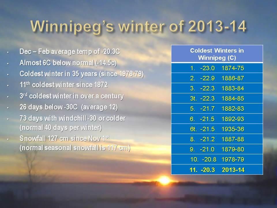
(NOTE: "Winter" is defined as the 3 month period from December through February)
Average winter temperature for Winnipeg : -14.5C (1981-2010 average)
Dec-Feb Dec-Feb
2011-12 2013-14
Avg temp ........................ - 9.7C .......... -20.3C
diff from normal .................. + 4.8C ......... - 5.8C
rank out of 141 years...... 4th warmest ..... 11th coldest
rank out of 141 years...... 4th warmest ..... 11th coldest
# of days above normal ........ 70 ........... 18
# of days below normal ........ 18 ............ 66
# of days > 10C below normal 1 ............. 25
# of -20C days .................... 24 ............ 75 (4th most in 141 winters)
# of -20C days .................... 24 ............ 75 (4th most in 141 winters)
# of -25C days .................... 8 ............ 55
# of -30C days .................... 0 ............. 27
One can see how this winter has been a complete flip from the winter of 2011-12. This winter is over 10C colder than 2 years ago, with 3.5 times the number of below normal days. The winter of 2011-12 was the 4th warmest on record in Winnipeg since 1872. This winter has been the 11th coldest, and the 3rd coldest in the last 120 years. Whereas we've seen almost a month's worth of -30C days this winter, there were NONE during the entire winter of 2011-12. Incredibly, there were only 8 days when the temperature went below -25C in 2011-12.. compared to 55 such days this winter. During the winter of 2011-12, there was only 1 day that was abnormally cold (>10C below normal). This winter, we've had 25 such days! It's like we moved 1000 km north this year! What happened?
One can see how this winter has been a complete flip from the winter of 2011-12. This winter is over 10C colder than 2 years ago, with 3.5 times the number of below normal days. The winter of 2011-12 was the 4th warmest on record in Winnipeg since 1872. This winter has been the 11th coldest, and the 3rd coldest in the last 120 years. Whereas we've seen almost a month's worth of -30C days this winter, there were NONE during the entire winter of 2011-12. Incredibly, there were only 8 days when the temperature went below -25C in 2011-12.. compared to 55 such days this winter. During the winter of 2011-12, there was only 1 day that was abnormally cold (>10C below normal). This winter, we've had 25 such days! It's like we moved 1000 km north this year! What happened?
BLAME IT ON THE JET STREAM
Why the dramatic difference between these two winters? The simple answer is due to the jet stream. The jet stream is a strong ribbon of air that flows across the mid latitudes and polar regions across the globe, and separates Arctic air to the north from warmer air to the south. It defines the storm track, along which storms are steered as they travel from west to east across the northern hemisphere. In the winter of 2011-12, the jet stream was quite strong but locked in a westerly orientation across the northern Prairies (see right image below), which effectively blocked intrusions of Arctic air from barrelling southward into the Prairies, while also allowing frequent invasions of mild Pacific air to spread east across southern Manitoba. As a result, temperatures were frequently above normal in this setup, with an average of 7 days above normal for every 2 below. Cold spells were brief and infrequent.
 |
| The behaviour of the jet stream dictates what kind of winter we'll have in southern MB. A wavy jet stream (left) increases likelihood of a colder winter, while a westerly jet stream (right) favours a milder winter with less frequent Arctic outbreaks |
So what dictates how the jet stream will set up? That depends on a number of factors, including large scale climatic oscillations such as the Arctic Oscillation (AO), the North Atlantic Oscillation (NAO), the Pacific Decadal Oscillation (PDO), Madden-Julian Oscillation (MJO) as well as ENSO phases (El Nino, La Nina) The interplay between these oscillations will favour a stronger westerly (aka "zonal") jet stream or a weaker "wavy" jet stream that can vary season to season, and year to year. In addition, some are saying that the rapid melting of the Arctic ice cap is resulting in a weaker jet stream (due to a weaker thermal gradient between the poles and the equator) which would tend to favour a "wavier" jet stream prone to blocking patterns. It's pretty complicated stuff that all depends on global temperatures, winds, ocean currents and ice cover.. so it's easy to understand why it's so difficult to predict what kind of winter we'll have in any given year. Suffice to say, both setups above can result in prolonged periods of abnormally warm or cold weather.. depending on which side of the jet stream you happen to be on. And based on what's been happening over the past few years, it's possible these types of extreme weather patterns may become more frequent in the future, leading to a greater number of abnormally mild or cold winters in the years ahead. Predictability however will continue to be a challenge, until a better understanding of these global interactions is realized. Until then, hope for the good side of the jet stream!
Rob, thank you for spending time compiling all these special winter stats for us, in the past week. An excellent job!!
ReplyDeleteWinds have really picked up in Portage La Prairie. Now gusting to 60 km/h!! Tonight looks nasty.
ReplyDeleteEC is now calling for the windchill to touch on -50 at times overnight.
Hey Rob - I want to 2nd the first Anon blogger. I'm almost sure some of the local TV weather "meteorologists" visit your page to get their facts. You do a remarkable service to the public with your blog and you are long over due for an award in my opinion. Keep up this excellent Work. Chris Gartner in Westwood.
ReplyDeleteChris, anonymous.. Appreciate the kind comments. I love talking about the weather, and it certainly is rewarding for me to hear that people find what I post here of interest to them as well. That's why I do this. Many thanks!
ReplyDeleteCan you post a windchill forecast for Winnipeg and southern Manitoba for the next 24 hours, by any chance?
ReplyDelete>>Anonymous said... Can you post a windchill forecast for Winnipeg and southern Manitoba for the next 24 hours, by any chance?
ReplyDeleteYou can try SpotWx for some great graphs that display 3-hourly values of temperature and windchill for any location. Here's the link for Winnipeg (SpotWx graphs for Winnipeg accessible from my main website under the forecast graphic)
http://spotwx.com/products/grib_index.php?model=gem_reg&lat=49.90403&lon=-97.22588&tz=-6
Unfortunately, these graphs use Flash software, so they're not accessible on many mobile devices. But there are links to tabular data that you can get on your phone.
Looks like some records will be challenged in the short term. The overnight low into tomorrow morning, and also the coldest daytime "high max " for March 1. The latter record should be the easier of the two.
ReplyDeleteRob definitely one of the best posts and informative.With patience, I can now wait for your blog to explain rather than hours and hours of mostly unproductive research (at least i tell my wife that)No longer Doubting This is the best blog.
ReplyDeleteTom
Thanks for the comments Tom! Glad I can provide some worthwhile information for you. I stride for accuracy in whatever I post, so that any information here is factual and trustworthy (as much as possible). I find there can be a lot of misinformation out there these days, so I like to make sure anything I post here is accurate and informative.
ReplyDeleteDown to -30C at YWG airport as of 11 pm.. so another -30C day this winter (makes 27 total so far, and tomorrow will make it 28)
ReplyDeleteAlso of note.. February will finish with an average temperature of -20.0C, our third month in a row with a monthly average of -20C or lower. That's only happened one other time in Winnipeg since 1872, during the winter of 1886-87. That shows how persistent the cold has been this winter.. though not necessarily record cold.
Rob,
ReplyDeleteWeather network is calling for snow on Thursday, is it going to be a big system?
I was really hoping that we would not have a repeat of last winter season's very cold March. Looking at the first 2 weeks of this March, we are going so far below normal, that we it would seem that we go worse than last year. Here's hoping the second half is much warmer.
ReplyDeleteMarch 1st and 45 cm snow depth is something I have never seen in my lifetime!!
Did we have the same setup in the winter of 2008-9. If so I see the point you make about Artic ice extent. The same thing appears to occur in the winter of 2008-9 .With the 2006 and 2007 record summer melts and the 08-09 djf -20,-19.4,-14.7. Ironically the 2005-6 winter was the warm one.
ReplyDeleteWinnipeg, Regina and Saskatoon all broke their all-time March wind chill lows this morning.
ReplyDelete>>Winnipeg, Regina and Saskatoon all broke their all-time March wind chill lows this morning.
ReplyDeleteImpressive. For Winnipeg, previous coldest wind chill was -49 on March 1 1962 (when we hit our record low of -37.8C that day). Note that wind chill records only go back to 1953... It's possible some of those cold March days in the 1800s may have had colder wind chills, but we don't have wind chill readings for back then.
Rob, I wonder if the coldest daytime high max for the month of March at -26.7C will be beaten today ?? Looking at your stats page that is the coldest I could find!!
ReplyDeleteAnonymous..
ReplyDeleteThat's correct.. the lowest maximum temperature in March was -26.7C on March 7 1880 (with a record low of -37.2C that day as well) As of 3 pm, the high temperature at YWG airport today has been -27.0C. We'll just have to wait and see if it can stay below that -26.7C mark over the next couple of hours.. but it's possible!
-26.6C at 4 pm, so we're just missing the all time record low maximum for the month of March, although it will be a record low maximum for March 1st (previous -22.2C on March 1 1972) and likely 2nd coldest ever daytime March maximum behind the 1880 mark.
ReplyDelete