Monday, December 30, 2013

Coldest December temperature in 80 years possible Tuesday morning as 2013 ends with brutal cold spell

Low temperatures from the
RGEM model valid Tuesday
morning Dec 31 2013.
Note pockets of -40C temps
across southern MB. 
Baby it's cold outside.. even for hearty Winnipeggers.  2013 is ending with a brutal cold spell with temperatures some 10-15C below normal for the end of December. Winnipeg has hit lows of -35C the past two mornings, with highs only in the minus 20s. And the worst is yet to come as the peak of the cold spell moves in by tonight. Today will be bitterly cold with highs barely nudging above the -30C mark. Luckily winds will be light to offset the frigid temperatures somewhat. Tonight however with clear skies and a light northwest wind, temperatures will plummet towards the -40C mark by Tuesday morning, and -50 with the windchill.. dangerous cold that can lead to frostbite within minutes, or deadly hypothermia if exposed to the cold for a prolonged period without proper clothing. If Winnipeg hits -40C early Tuesday, it would mark the first time the city has hit the -40C mark in almost 7 years (a low of -41.7C on Feb 5 2007)  It would also mark the first time in 80 years that Winnipeg has hit the -40C mark in December, a feat last achieved on Dec 28 1933 with a temperature of -41.1C. This shows how unseasonably early this cold snap has been, with similar cold spells more typical here in January or February.  The cold weather is expected to persist though New Years Day and Thursday, before another Alberta clipper brings in snow and moderating temperatures Friday. The respite however will be short lived as we get back into below normal temperatures again next weekend into next week. Bundle up and stay warm folks!  Bitter cold is here for awhile!

UPDATE Dec 31: Official low at YWG airport was -37.9C this morning, which makes it the coldest December temperature in Winnipeg since 1933.  The -37.9C low this morning just edges past the -37.8C readings recorded on Dec 31 1967 and Dec 31 1973. It was not a record low for the day however, which still stands at -38.3C on Dec 31 1884.  (Click here for list of daily December temperature records for Winnipeg since 1872)

Thursday, December 26, 2013

Mild end to the week.. then snow Friday night into Saturday heralds arrival of another deep freeze to cap off frigid December

Forecast snowfall amounts from
GEM model through Saturday
showing swath of 10+ cm across
southern Manitoba 
The week will be ending on a mild note across southern MB as temperatures climb towards the freezing mark Friday thanks to a westerly flow of mild Pacific air spreading in from Alberta. The mild temperatures however will be nothing more than a brief tease from Mother Nature, as another blast of Arctic air moves in over the weekend into next week. The deep freeze will be ushered in by a clipper system from Alberta which will track east and spread snow across southern Manitoba Friday night into Saturday morning, with 5-10 cm possible across Winnipeg and the Red River valley and 10-15 cm across the western parklands.  The snow will be accompanied by brisk northerly winds gusting to 50 km/h which will send temperatures tumbling into the minus twenties Saturday, along with blowing and drifting snow and wind chills approaching minus 40.. a shocking change from the pleasant conditions Friday.  Bitterly cold temperatures will prevail Sunday through New Year's Day with highs only in the minus 20s and lows in the minus 30s, capping off what will be the coldest December in Winnipeg since at least 2000. So enjoy the next couple of days.. another Arctic blast is on the way!          

December 2013 is running some
7C below normal across
southern Manitoba and
northern Plain states  
How cold has it been this December in Winnipeg? Through Christmas, the average temperature this month has been -20.2C, or about 7C below the normal December average (-13.5C, 1981-2010 average). Since December 4th, only 2 days have been above normal this month, with another frigid spell forecast to end the month. This will likely end up being the coldest December in Winnipeg since at least 2000, when Winnipeg recorded a December mean of -22.0C, its 4th coldest December on record (since 1872)  The coldest December on record in Winnipeg was way back in 1879 with a bone chilling mean of -26.0C for the month. That month also featured the coldest temperature ever recorded in Winnipeg with a -47.8C reading on December 24th. 

Monday, December 23, 2013

Snow and strong winds moving in overnight into Christmas Eve morning.. quiet weather expected for Christmas

A band of snow over western Saskatchewan this evening is forecast to track east into southern Manitoba tonight reaching Winnipeg and the Red River valley overnight into the morning rush hour. Not a lot of snow is expected in Winnipeg.. perhaps 2 cm or so.. but strong southerly winds gusting to 60 or 70 km/h will produce considerable drifting and blowing snow, with poor visibilties likely in open areas. This area of snow is expected to move off by midday Tuesday, with diminishing winds and milder conditions for the afternoon. Seasonably cold weather is expected through the Christmas holidays with no major snowfalls.. good news for travellers.. before our next chance for more significant snow by Saturday as a clipper system moves into southern MB. Whatever the weather.. have a safe and happy holiday season. Season's greetings from Rob's Obs!

Sunday, December 15, 2013

After coldest December temperature in Winnipeg in 40 years.. a big, but temporary, warm-up on the way Monday..

Minimum temperatures (C)
Sunday Dec 15 2013
Record lows over much of MB
An arctic ridge of high pressure sprawled across Manitoba Saturday night brought some record cold temperatures early Sunday with temperatures plummeting to the -35 to -40C range over southern Manitoba, and -43C in Thompson. In Winnipeg, the thermometer at Winnipeg airport bottomed out at -37.3C Sunday morning, setting a new record low for Dec 15th, eclipsing the previous record of -37.2C set way back in 1879. (records began in 1872) For Winnipeg, it was the coldest December reading in 40 years, since a -37.8C reading on December 31 1973. That -37.8C reading, tied on Dec 31 1967, stand as the coldest temperatures ever recorded at Winnipeg airport in the month of December since records began there in 1938. However, previous to 1938, much colder temperatures have been recorded in Winnipeg in December at the former weather observing site at St John's College which took weather observations from 1872 to 1938. This included Winnipeg's all time coldest temperature during a remarkable cold snap in December 1879 that saw the temperature plummet to a record low of -47.8C on Dec 24 1879. The high that day was only -39.4C, making it the coldest day in Winnipeg history since records began in 1872.  By the way, the last time a reading of -40C or lower was recorded in December in Winnipeg was December 28 1933 with a low of -41.1C.

Coldest December temperatures in Winnipeg over the past 50 years  (since 1963)

Dec 31 1973 ............. -37.8C
Dec 31 1967 ............. -37.8C
Dec 15 2013 ............. -37.3C
Dec  24 1996 ............ -37.0C
Dec 12 1995 ............. -37.0C
Dec 20 1989 ............. -37.0C 

But enough about the cold.

Temperature map valid 1 pm Sunday Dec 15th 2013
Note large wave of mild air over western Canada
poised to spread east over the next 24 hours 
The frigid cold snap which has been locked over Manitoba for the past 10 days, will finally break Monday as a warm front from western Canada moves east and spreads a westerly flow of milder Pacific air across southern Manitoba. This will allow temperatures in Winnipeg to climb into the minus single digits Monday afternoon for the first time in two weeks. Note however, that in advance of the warmup, a band of snow ahead of the warm front will push into Winnipeg and the Red River valley by late Sunday afternoon giving a few hours of snow through the evening. 2-4 cm is possible along with reduced visibilities in blowing snow as southerly winds increase through the evening.

The milder weather is expected to last into Tuesday, but unfortunately it doesn't look like this will be a sustained warmup. Another clipper is expected by midweek with more snow (possibly another 2 to 5 cm), followed by a reinforcing shot of Arctic air by the end of the week into next weekend that will send temperatures back well below normal over southern Manitoba through the Christmas holidays. So enjoy the next couple of days of relief while you can!

Temperature trace from Rob's Obs weather station
Charleswood, Winnipeg - Dec 16 2013
showing dramatic temp rise from Sunday morning
UPDATE: Dec 16 2013
Temperature rises to -1.9C at YWG airport Monday afternoon, a phenomenal rise of over 35C within 30 hours from Sunday morning's low of -37.3C. The graph left shows the dramatic temperature rise as measured at my backyard weather station in SW Winnipeg. Note the steeper temperature rise around noon when winds shifted into the west and tapped the mild Pacific airmass.

Friday, December 06, 2013

Deep freeze settles in after mid week snowstorm..

CPC 6-10 day outlook does
not look promising for those
looking for mild weather 
The storm system that dropped 15 to 25 cm of snow across the Red River valley and southeastern MB Tuesday into Wednesday has long since moved out of the region, but in its wake, frigid Arctic air is flooding into southern MB as a massive Arctic ridge pushes in from the west.  The core of the coldest air is found over Alberta and western Saskatchewan today where temperatures have struggled to get much above the -30C mark this afternoon. This ridge will build into North Dakota over the weekend, maintaining its icy grip over the Prairies. Temperatures in Winnipeg are expected to stay at or below the -20C mark through much of next week, with overnight lows approaching the -30C mark. West to southwest winds of 20 km/h will produce windchills in the minus -30s during the day, and close to -40 at night. Temperatures are expected to moderate a bit for the end of next week as a weak system crosses southern MB, however below normal temperatures are likely to continue for the foreseeable future. Bundle up and hunker down! Mid winter cold has come to town!    
 

Tuesday, December 03, 2013

Driving conditions to worsen Wednesday into Thursday as storm system brings snow and increasing winds to southern MB..

Model ensemble snowfall totals
forecast through Thu morning (cm)
15-20 cm possible over RRV
and SE MB
The storm system that will be tracking across the Dakotas through Minnesota will be spreading snow across southern MB overnight through Wednesday, along with increasing northerly winds as the system intensifies to our southeast. Although the heaviest amounts of snow are expected mainly across northern Minnesota into NW Ontario with this system, it looks like southeastern MB and the Red River valley will still be getting a good amount of snow on the northwestern flank of the storm. Light snow this evening will pick up overnight with about 2-4 cm expected by the Wednesday morning commute. Snow will continue all day Wednesday into Wednesday night becoming moderate at times. Another 10 cm of snow is expected in the Winnipeg area by Thursday morning with up to 15 cm over areas to our south and east.  Snow will finally taper Thursday but not before storm totals of 10-20 cm over the RRV and SE Manitoba. In addition to the snow, northerly winds will be steadily increasing Wednesday as the storm intensifies, with gusts to 50 or 60 km/h likely by afternoon and evening.  This will lead to extensive blowing and drifting snow with poor visibilities becoming more frequent by evening especially in open areas. As a result, driving conditions will steadily worsen Wednesday into Wednesday night, so allow a lot of time if you plan on travelling. The snowfall will be winding up Thursday, but gusty winds and cold temperatures will continue to produce poor driving conditions especially Thursday morning. Allow plenty of time for commuting and getting to your destination over the next couple of days as this next bout of wintery weather hits southern MB.  

Environment Canada has issued a special weather statement for southern MB concerning this storm system, with winter storm warnings in effect across North Dakota and northern Minnesota.

Monday, December 02, 2013

Storm system taking track further south.. less snow now expected for southern MB

Storm snowfall forecast through
Wednesday night.
Highest amounts expected
south of US border
The winter storm that has been pounding Alberta and southwest Saskatchewan will be heading east over the next day or two, but is now expected to impact areas mainly south of the international border. As a result, southern MB will be seeing less snowfall Tuesday through Wednesday as the storm tracks through the Dakotas. It now looks like areas along and south of the Transcanada highway will be seeing about 5 to 10 cm of snow through Wednesday with the highest amounts near the International border. Heavier snowfall is expected across North Dakota and Minnesota where winter storm watches and warnings are in effect, in anticipation of 15 to 25 cm of snow along with increasing winds and poor visibilities in snow and blowing snow. In the wake of the storm system, colder weather will be flooding into southern Manitoba with temperatures in the minus 20s for the end of the week through the weekend.

Sunday, December 01, 2013

Winter storm gaining strength over western Canada.. impacts to spread over southern Manitoba Monday through Wednesday..

Winter storm and blizzard warnings
cover much of western Canada
Sunday evening
A major winter storm is gaining strength over the Canadian Rockies this evening.. and this storm will be spreading its wintery impacts across the southern Prairies into southern Manitoba over the next few days. Winter storm and blizzard warnings are out for much of Alberta and southern Saskatchewan as the storm intensifies tonight into Monday bringing snow, increasing northerly winds and falling temperatures across the western Prairies. The first wave of snow from this system is expected to spread over southern Manitoba Monday with a few cm possible especially over SW Manitoba where 5-10 cm is possible.  The storm is forecast to track across Montana and through the Dakotas spreading another wave of snow across southern Manitoba Monday night through Tuesday into Wednesday. There remains considerable uncertainty as to how intense this storm system will be by the time it reaches southern Manitoba by Tuesday. Some models are suggesting the storm will re-intensify over the Dakotas bringing significant snow and possible blizzard conditions to southern MB and the Red River valley Tuesday into Wednesday. Other guidance shows the storm tracking mainly south of the border with minimal impact over Winnipeg and the northern Red River valley. At this point, it's best to be prepared for a possible significant snowfall event Tuesday into Wednesday across southern MB, especially over SW Manitoba and the southern Red River valley with areas of blowing and drifting snow increasing by Wednesday. More details will become clearer as the storm evolves over the next 24 hours. Note that winter storm watches are now in effect across all of North Dakota and northern Minnesota in advance of this system, so be prepared for adverse winter weather if you have any travel plans to the west and south of Winnipeg over the next couple of days.

Keep track of weather conditions across southern Prairies and North Dakota via webcams from Rob's Obs webcam page.  

Friday, November 29, 2013

Tranquil weather over the weekend.. then major storm possible over southern MB by middle of next week followed by Arctic blast..

ECMWF model valid 6 am Thu Dec 5
showing possible major storm
impacting southern Prairies
The weather over southern MB will be generally tranquil for the next few days with no major systems expected to impact the area. Generally cloudy skies and seasonable temperatures are forecast over the weekend before an increasing chance of some snow by next Monday and Tuesday as a storm system tracks through southern AB into southern SK. Things may get a lot more interesting by next Wednesday into Thursday as long range models are indicating the potential of a powerful Colorado low system impacting southern MB and southern SK. It is much too early to be more specific on who will bear the brunt of this storm, if it all, but at this point, it's prudent to be aware that there is the potential for a major storm system to affect parts of southern MB and southern SK by the middle of next week. One thing that looks more certain is the change to much colder weather in the wake of this system later in the week through next weekend, with highs in the minus 20s and low in the minus 30s possible along with colder wind chill values. Get ready folks.. a blast of Arctic weather is on the way next week!          

Sunday, November 17, 2013

First significant snowfall of the season hits Winnipeg/RRV..

Webcam showing downtown Winnipeg
Sunday morning Nov 17 2013
Winnipeggers awoke to the first blanket of snow of the season Sunday morning as a weak storm system crossed southern MB overnight. About 3-4 cm of snow fell in the city overnight with amounts of up to 10 cm reported northwest of Winnipeg through the Portage La Prairie to Woodlands area. In addition, brisk northerly winds gusting to 50 km/h and temperatures near -3C were causing slippery conditions on area roadways, forcing the closure of the TransCanada highway between Headingley and Portage La Prairie Sunday morning.  Snow will continue this morning but will taper off by afternoon as the storm system weakens while a more powerful storm system intensifies over northern Ontario.

Saturday, November 09, 2013

Cold blast moving in Sunday.. but short lived..

An acrtic cold front will be pushing across southern MB Sunday ushering in a northerly flow of much colder air from the Arctic for Sunday afternoon into Monday.  The cold front will be pushing through Winnipeg around midday Sunday with a few flurries, then gusty northwest winds will develop behind the front with falling temperatures in the afternoon. Midday temperatures near -1 or -2C will fall to -8C by evening, and -12 to -15C by Monday morning. Remembrance Day will be sunny but cold, with afternoon highs near -8C and northwest winds of 20 km/h. The good news is that this blast of cold air will be short lived as winds shift into the south on Tuesday bringing in moderating temperatures by midweek. By Wednesday, highs will be back on the plus side, with highs rising above normal to around +6C. Seasonable temperatures are expected for the latter half of the week along with generally fair conditions.              

Thursday, November 07, 2013

Snow moving into Winnipeg/RRV Friday afternoon into Friday evening..

A clipper system from western Canada will track across southern MB Friday, bringing an area of snow with it. Snow from this system is expected to spread into Winnipeg and the Red River valley from the west Friday afternoon into Friday evening, with some slushy accumulations possible Friday night. Temperatures Friday afternoon should be near or just above freezing before the precipitation starts, so snow will likely be melting at first. However, as temperatures cool Friday evening, snow will likely start accumulating, especially on grassy surfaces, with amounts of 2-3 cm possible by Saturday morning. Northwesterly winds behind this system will usher in colder temperatures for Saturday along with occasional flurries. Much colder but dry conditions are expected early next week before temperatures moderate again later in the week.      

Wednesday, October 30, 2013

Halloween weather in Winnipeg

The weather is not looking too frightful this year for Halloween in southern Manitoba. Pleasant conditions are expected with afternoon highs slightly above normal at +8C under partly sunny skies and light winds. Temperatures are expected to be near +5C around 6 pm falling to 0C by midnight for evening trick or treaters. Last year, Winnipeg had a high of +5C on Halloween, with patchy drizzle in the evening and temperatures near +2C.  Overall, the weather is not looking too bad for this time of year, which history has shown can range from pleasant to downright terrifying in Winnipeg on Halloween. Some of the more significant Halloween weather Winnipeg and area has experienced since 1950 includes..

1955.. A steady snow starts around midday Halloween and continues through the evening. 9 cm of snow accumulates by midnight with evening temperatures near -2C. This snowfall would signal the start of Winnipeg's snowiest winter on record, with a phenomenal 252 cm of snow falling by April, over twice a normal winter snowfall.

1957, 1958 ... 2 consecutive mild Halloweens, with sunny 15C weather.

1971... Winnipeg's whitest Halloween. An early season snowstorm starts on the morning of the 30th and continues until the early morning of the 31st. By the time it was over, 28 cm of snow had fallen on the city turning Halloween into a winter wonderland. 18 cm of snow was still on the ground the morning of Oct 31st.

1979... Winnipeg's scariest Halloween.. weatherwise. Rain and wet snow during the afternoon changes to steady snow in the evening, accompanied by northerly winds of 50 km/h gusting as high as 78 km/h and temperatures near the 0C mark. Although only 2 cm of wet snow fell in Winnipeg, heavier amounts of 15-25 cm fell east of the city to the Ontario border. Winnipeg police reported it was one of the quietest Halloweens they ever had due to the poor weather keeping many home. Twas a night fit for neither man nor beast.

1990... One of Winnipeg's warmest Halloweens with a high temperature of 17.2C.

1991 ... One year later, it was one of the coldest Halloweens on record with a high of -7.5C and a low of -15.3C in Winnipeg, along with 4 cm of snow on the ground. Temperatures ranged between -8C and -10C Halloween evening, but winds were light so windchill was not a big issue.  Further south, Minnesota was being clobbered by a massive early season blizzard that dumped over 36" of snow in Duluth and 28" of snow in Minneapolis.       

1996..  Another cold Halloween with a daily high of -3.4C and a low of -12.8C along with 2 cm of snow on the ground. Evening temperatures were between  -8C and -12C, but 15 km/h winds produced windchills of -15 to -19C, making it feel even colder than 1991.      

1999 ... Warmest Halloween in modern times. Temperatures climb to a high of 17.7C in Winnipeg, while the mercury soars to 24C over the southern Red River valley at Emerson and Gretna. Temperatures were still at a balmy 16C Halloween evening in Winnipeg making it feel more like the end of September than October.

2000 .. A soggy Halloween. 11.6 mm of rain falls during one of Winnipeg's wettest Halloweens. At least it was mild with highs near 13C but also fog and mist to add to the spooky atmosphere.  

Whatever the weather, have a safe and enjoyable Halloween!  

Saturday, October 19, 2013

Clipper to bring first snow of season to SW Manitoba into North Dakota.. pattern change to colder weather

12 hr snowfall amounts from RGEM
valid 7 am Sun Oct 20 2013
dark blue: 1 cm, darker green: 5 cm
A clipper system over Saskatchewan today will track into North Dakota tonight bringing the first accumulating snow of the season to parts of SW Manitoba and North Dakota. The precipitation is expected to push into SW Manitoba later today into this evening, possibly starting as rain before changing to all snow tonight. About 2-5 cm of snow is expected along a path from the Roblin/Riding Mtn Park area through Brandon into the Pilot Mound/Turtle Mtn area into North Dakota. Locally higher amounts are possible over higher elevations. The system will track into North Dakota Sunday and will signal a pattern change to colder than normal weather over southern MB for the balance of the week, likely persisting through the rest of the month. Occasional snowshowers are likely Sunday across southern MB, including Winnipeg, with localized heavier snowbands possible to the south of lakes Winnipeg and Manitoba.  Ready or not folks.. colder weather is on the way!  

Monday, October 07, 2013

Pleasant fall weather continues through mid week.. Storm system threatens rain by end of week

Pleasant fall weather will continue over southern MB over the next couple of days as an upper ridge crosses Manitoba maintaining dry and warmer than normal conditions. Temperatures will climb to the 20C mark Tuesday with partly sunny skies and light breezes.  Temperatures will remain above normal in the mid to upper teens through Thursday before the next threat of rain by Friday as a Colorado low storm system tracks into southern MB. At this point, it appears that the bulk of heaviest rain with this system will be over western MB and along the SK border where 25 to 50 mm is possible Friday into early Saturday.

Monday, September 30, 2013

Nice finish to a nice month..

September will be ending on a mainly sunny and warm note today over the Red River valley as a southwest flow of  mild air pushes temperatures into the low 20s this afternoon. A weak cold front will push in from the west later today into this evening bringing a slight chance of showers, ushering in slightly cooler and windy conditions for the first day of October. Brisk westerly winds Tuesday will be gusting to 60 or 70 km/h but temperatures will remain above normal with highs in the upper teens with a mix of sun and cloud. Normal highs at this time of year are now around the 15C mark. Above normal temperatures are expected to continue through midweek before cooler and more unsettled conditions move in for the end of the week. All in all, a nice stretch of weather to end off September which will finish some 3C above normal for the month.

Thursday, September 26, 2013

Showers finally clip Winnipeg.. heavier rain likely over SE Manitoba Friday into Saturday

An area of showers and scattered thunderstorms over the western RRV pushed north across Winnipeg late this morning, bringing about 5.5 mm of rain to Winnipeg airport through midday. It wasn't much, but it was the most significant rainfall in the city since August 18th when 30 mm fell during a thunderstorm. Today's rainfall brought the monthly total to 10.5 mm at YWG airport, still well below the normal September rainfall of 45.5 mm (1981-2010 average)

24 hr rainfall amounts from GGEM
through Sat evening. Yellow marks
15 mm, orange 25 mm, green 5 mm. 
Regardless, the rain was welcome, and we could be in for some more rain Friday into Saturday as a stationary frontal system sets up along the MB/Ontario border, with a couple waves of rain spreading north along the boundary. At this point, it looks like the bulk of the heaviest rain will be over SE Manitoba into Lake of the Woods/NW Ontario where 25-50 mm of rain is possible by Saturday evening. (see image left) Amounts will be less over Winnipeg and the RRV, with a sharp dropoff in rain amounts west of the RRV. For Winnipeg, rainfall amounts of 5-10 mm are possible Friday afternoon into Saturday morning with higher amounts expected east of the city. However, if the rain shield edges further west as some models have been suggesting, Winnipeg could also see higher amounts.

UPDATE: (7 pm Sept 28) Rainfall amounts through 7 pm (since midnight)

Winnipeg airport ...............  20 mm
Winnipeg Forks ................  24 mm
Winnipeg Charleswood .....  24 mm   (Rob's Obs)

Sprague ............................  45 mm  (95 mm since Friday morning)
Kenora .............................. 40 mm  (88 mm since Friday morning)
Falcon Lake ....................... 33 mm
Dugald ............................... 31 mm
Selkirk ............................... 31 mm
Steinbach ..........................  26 mm
Pinawa ............................... 25 mm
Letellier .............................. 21 mm
Emerson ............................  20 mm
Morris ...............................  19 mm
Morden .............................. 16 mm
Winkler .............................  15 mm
Carman .............................  13 mm
Portage LP ........................    7 mm

Data sources... Env Canada, MB agriculture and WxUnderground sites. Data is unofficial and has not been quality controlled.

Tuesday, September 24, 2013

Dry spell continues as rain eludes Winnipeg/Red River valley

Rainfall in Winnipeg over
the past 30 days. Only 6 mm
has fallen since August 19

Showers and scattered thunderstorms brought some beneficial rain to western Manitoba and the Interlake regions Monday with general amounts of 15 to 30 mm recorded, but for Winnipeg and much of the Red River valley and SE Manitoba, it was another dry day as rain from the system bypassed the area to the west and north. It's been a dry September in Winnipeg and much of the RRV, with only 4 mm of rain recorded at Winnipeg airport this month, and only 6 mm over the past 6 weeks. The last significant rainfall in Winnipeg was during a heavy thunderstorm on August 18th when 30 mm fell in about an hour. Since then, rainfall has been scarce with minor amounts falling on a few days, with heavier showers often bypassing the city.  Normal September rainfall is 45.5 mm in Winnipeg (based on 1981-2010 averages), so we are running well below normal for the month.  This is very similar to last fall when Winnipeg recorded its second driest September on record with only 4 mm falling during the entire month. 

As for this week, the next chance for precipitation in Winnipeg will be Thursday as a storm system pushes across western Manitoba. Once again however, it looks like the bulk of precipitation with this system will be mainly west of the Red River valley. Models are indicating the possibility of a second system bringing more widespread rain to Winnipeg and the RRV Friday night into Saturday, which hopefully pans out as we can use the rain.  Last fall, tinder dry conditions in September led to several wildfires in early October, including one near Vita MB that damaged several homes and forced the evacuation of the entire town.       


Saturday, September 21, 2013

First frost of the season in Winnipeg ends growing season at 131 days.. record crop yield reported by area farmers

2013 saw one of the best crop yields on record
over the Red River valley
The 2013 growing season for Winnipeg officially ended this morning with a low of -1.3C recorded at the Winnipeg airport site.  The last spring frost this year was on May 12th, giving a growing season length of 131 days this year, 10 days above the average length of 121 days (at Winnipeg airport)  Normal first fall frost at the airport is Sept 22nd, while the average last spring frost is May 23rd. Not all areas of the city however saw frost this morning, as an area of lake effect cloud streaming off Lake Winnipeg kept temperatures above freezing over northern and eastern sections of the city and areas to the north and east. At my site in Charleswood, I had a low of +0.4C, with some patchy frost noted.

After one of the latest springs on record this year, the 2013 growing season did quite well, with area farmers reporting record crop yields this year thanks to favourable weather conditions and a fine late summer that extended the growing season into late September.  This comes after another exceptional year in 2012 that also saw a bumper crop helped in part by one of the earliest springs on record in southern Manitoba.      

Friday, September 13, 2013

Warm and breezy day ahead.. cooling off for the weekend..

It will be a beautiful end to the week today as clear blue skies and southerly breezes push temperatures into the mid 20s this afternoon, some 8C above normal for mid September. Southerly winds will steadily increase today from 20 km/h this morning to 30 gusting 50 km/h by mid to late afternoon, especially in Winnipeg as southerly winds funnel up the Red River valley.  A cold front will push through southern MB from the north overnight ushering in cooler temperatures for the weekend as winds shift into the north Saturday. High pressure will build over western MB by Sunday morning, bringing chilly morning lows in the single digits, as well as a threat of frost over western MB and the interlake areas. Warm and dry conditions are expected to return again early next week before an increasing chance of showers by Thursday. Overall, it's been a fine late summer in southern MB with temperatures averaging some 4C above normal since mid August.  

Friday, September 06, 2013

September sizzler! Winnipeg records hottest September day in 30 years. Cooler weather for the weekend with showers by Monday..

3 pm temperatures across southern MB
Sept 6 2013 
It was a September sizzler as the remnants of a very warm airmass from western Canada pushed over southern Manitoba today sending temperatures into the low 30s this afternoon, with humidex values peaking around the 40 mark.. almost unheard of for September. In Winnipeg, temperatures peaked at 33.8C at YWG airport, making it the hottest September day in the city in 30 years since a 38.8C reading on Sept 2 1983. A weak cold front pushing south from the interlake was producing some widely scattered thunderstorms late today, and a severe thunderstorm watch was issued for much of southern MB including Winnipeg and the Red River valley.  Not everyone will see storms this evening due to their isolated nature, but the potential is there for some of these storms to become severe with strong wind gusts and large hail as the main threats.

This front will usher in cooler and less humid air for the weekend with sunshine and 25C temperatures for Saturday.. a fine looking start to the weekend. Clouds will be spreading in on Sunday as a disturbance tracks across the northern Plain states, which will likely bring some showers and embedded thunderstorms over southern MB including the Red River valley Sunday night into Monday. This could be the most significant rainfall in Winnipeg since a thunderstorm brought 30 mm of rain to the city back on August 18th. Since then, rain has been scarce with only 2 mm falling in Winnipeg over the past 3 weeks.    


Friday, August 30, 2013

Labour Day weekend outlook.. unsettled start, nice finish.

After a blast of late summer heat, the summer of 2013 will be winding down this weekend as we roll into September. The last weekend of the traditional summer will start off warm and humid Saturday, but things will become more unsettled as a cold front pushes across southern MB bringing a few showers and thunderstorms by the afternoon. This activity is expected to push across Winnipeg and the RRV Saturday afternoon into the evening, with brisk northwest winds ushering in cooler air Saturday night into Sunday. Sunday will see a return to sunshine, but temperatures will be noticeably cooler than the past 2 weeks with highs only around 20C, which is actually fairly close to normal for early September. This will set the stage for a beautiful end to the Labour Day weekend with sunny skies and highs in the low to mid 20s for holiday Monday.  Generally above normal temperatures are expected to continue for the first week of September.

Monday, August 26, 2013

Hot weather to continue this week..

It was another hot day in Winnipeg and southern MB with temperatures again reaching the low 30s. In Winnipeg, today's high of 32.8C was the third straight day of 30C+ temperatures, and it looks like we'll be near or above the 30C mark much of the week. A massive dome of hot air over the central US is bulging north into southern MB, and the pattern will be persistent all week. The net result will be more summerlike weather for Winnipeg and southern MB through the end of August.. a welcome extension of summer that was interrupted by a 4 week stretch of cooler weather from mid July to mid August. The weather this week should be generally dry, although scattered thunderstorms are possible from time to time as weak impulses tap the hot and humid air to generate locally strong thunderstorms at times. High temperatures will be in the upper 20s to low 30s, with humidex values in the upper 30s to near 40 at times. Long range guidance is indicating a change to cooler weather possible over the Labour day holiday weekend. 
   

Thursday, August 22, 2013

Thunderstorms possible Friday night/early Saturday as heat and humidity rise for the weekend..

Hot and humid weather will be
returning to southern MB
this weekend 
After a couple of beautiful pleasant days with low humidity and mid 20 temperatures, things will be getting hotter and more humid over the weekend as a warm front pushes across southern MB. This front will usher in temperatures back in the thirties, along with noticeably more uncomfortable conditions as humidex values climb near the 40 mark over the weekend with increasing humidity levels.  As the front pushes through Friday night, scattered thunderstorms will move across southern MB Friday night into early Saturday, with locally heavy rain, hail and intense lightning possible. Skies will clear out Saturday as the storms move out, leaving hot and humid conditions for the weekend with temperatures climbing into the 30-34C range across southern MB.  Hot weather is expected to continue through much of the upcoming week, with temperature near or above the the 30C mark all week, along with the threat of scattered thunderstorms from time to time as weak impulses pass through southern MB. All in all, it looks like Mother Nature will be making up for some of our lost summer earlier this month. Stay cool!            

Wednesday, August 14, 2013

Pattern change signals return of summer warmth to southern MB

After 4 weeks of below normal temperatures, a major shift in the upper atmospheric weather pattern will finally signal a return to more typical summerlike weather over southern MB.  The weather pattern over the past month has been dominated by a persistent upper trough over Hudson Bay into the Great Lakes that has resulted in  a prolonged period of below normal temperatures over the eastern prairies into Ontario. Including today (August 14th), Winnipeg will have gone 27 consecutive days below normal, at a time when the hottest weather of the season often occurs. During this stretch, Winnipeg has hit the 25C mark only twice, with a maximum of only 25.2C.  The normal high during this period is 26C.

The below normal streak however will be coming to end starting tomorrow. The persistent upper trough over central Canada will finally be shifting east and replaced by an upper ridge over the Prairies, allowing warmer air from western Canada to finally spread eastward. High temperatures in southern MB will climb from the mid 20s today to the 30C mark by Friday, with 30c+ weather expected over the weekend into next week. Things may start getting a little more unsettled as well Sunday into Monday as a weak impulse passes though southern MB, tapping warm and more humid air and triggering scattered thunderstorms. Above normal temperatures however are expected to persist much of next week, great news for those who weren't quite ready to say goodbye to the summer of 2013 just yet.      

Tuesday, August 06, 2013

Below normal pattern continues this week.. moderating trend expected over weekend into next week

500 mb pattern for Wednesday Aug 7
Note deep Hudson Bay vortex over
northern Manitoba 
Those waiting for summer heat to return to southern Manitoba will be disappointed this week as another surge of cooler than normal temperatures spreads across the eastern Prairies. A deep Hudson Bay vortex (image left) will drift across northern MB into NW Ontario, bringing a surge of cool air over Manitoba for the next few days. Temperatures will struggle in the mid to upper teens over Winnipeg and the Red River valley, some 5-10C below normal for early August.

Temperature graph for
Winnipeg past 30 days  
This will continue a trend of cooler than normal weather that began around July 19th over southern MB. Since then, Winnipeg has gone 19 consecutive days below normal as of today (August 6th) with temperatures more reminiscent of late August or September than mid summer.  The upper vortex is forecast to slowly drift east into Ontario over the weekend, with a gradual moderating trend expected over southern Manitoba into next week.
      

Monday, July 22, 2013

Cool week ahead..

It won't be very summerlike this week as a large-scale upper trough sets up over Ontario bringing a northwest flow of generally below normal temperatures over southern MB for the upcoming week.  High temperatures this week will generally be running in the low 20s, some 3-5C below the average high of 26C for this time of year, making it feel more like mid to late August. For today, brisk northwest winds and generally cloudy skies will keep temperatures only near 20C before skies clear tonight allowing temperatures to dip into the single digits overnight. Tuesday looks more pleasant with sunshine and lighter winds, and afternoon highs near 24C.  Another disturbance tracking through southern MB threatens more showers and possible thunderstorms for Wednesday into Wednesday night, followed by a reinforcing shot of cooler air for Thursday.  Highs pressure building into southern MB is expected to bring sunshine and pleasant conditions for the weekend with temperatures around the 22-24C mark. Long range guidance is hinting at a return to more summer like weather next week.

Wednesday, July 17, 2013

Showers and thundertorm possible overnight into Thursday.. cooler weather for weekend

A wave of low pressure moving along a frontal system just south of the US border will bring an increasing threat of showers and thunderstorms to southern MB overnight into Thursday morning. Locally heavy downpours are possible with this activity, with rainfall amounts of 15-25 mm possible in some areas.  As this precipitation moves out by midday, a trailing cold front will bring the threat of more thunderstorms Thursday afternoon into Thursday evening, especially across southwestern MB. This cold front will mark the leading edge of cooler air that will flood into southern MB Friday into Saturday.  Daytime highs Saturday will only be around 20C, with overnight lows likely dipping into the single digits by Sunday morning. Warmer weather is expected to return early next week with highs back in the upper 20s.  

Sunday, July 07, 2013

Showers and thunderstorms likely Monday night into Tuesday.. then turning warmer and drier for end of week..

After a stormy end to June with bouts of heavy rainfall, Winnipeg has yet to see any precipitation in July as a drier and warmer weather pattern evolves. Strong thunderstorm activity last evening over western MB pushed into the RRV overnight, but only managed to produce a few raindrops in the city as the storms weekened or split. The next threat of significant rainfall for the city will be Monday night into Tuesday as a storm system from Montana tracks into North Dakota. This system will likely spread an area of showers and thunderstorms along the US border which will push into southern MB Monday night into Tuesday. Some of the rain will be heavy with these thunderstorms with rainfall amounts of 25-50 mm possible in some areas, along with the potential for hail and frequent lightning. Things should clear out Tuesday evening with a return to drier and warmer weather for the latter part of the week.              

Sunday, June 30, 2013

Hot week ahead as heat wave builds over western Canada

A massive upper ridge over western North America is producing some of the hottest weather in years over parts of the western US, and some of this heat will be spreading across western Canada and the Prairies this week. BC and Alberta will see the hottest weather over the Canada Day weekend before the heat spreads east over the eastern Prairies during the upcoming week. For Winnipeg, sunny warm weather will prevail today and Canada Day with temperatures in the upper 20s along with light winds and comfortable humidity.  The heat starts turning up Tuesday and Wednesday as temperatures climb into the low 30s under sunny skies. A weak front may bring some scattered thunderstorms by Thursday and Friday, with slightly cooler weather expected over the weekend.  

Tuesday, June 25, 2013

First 30C of the year possible for Winnipeg today.. severe thunderstorms likely over SW Manitoba by evening

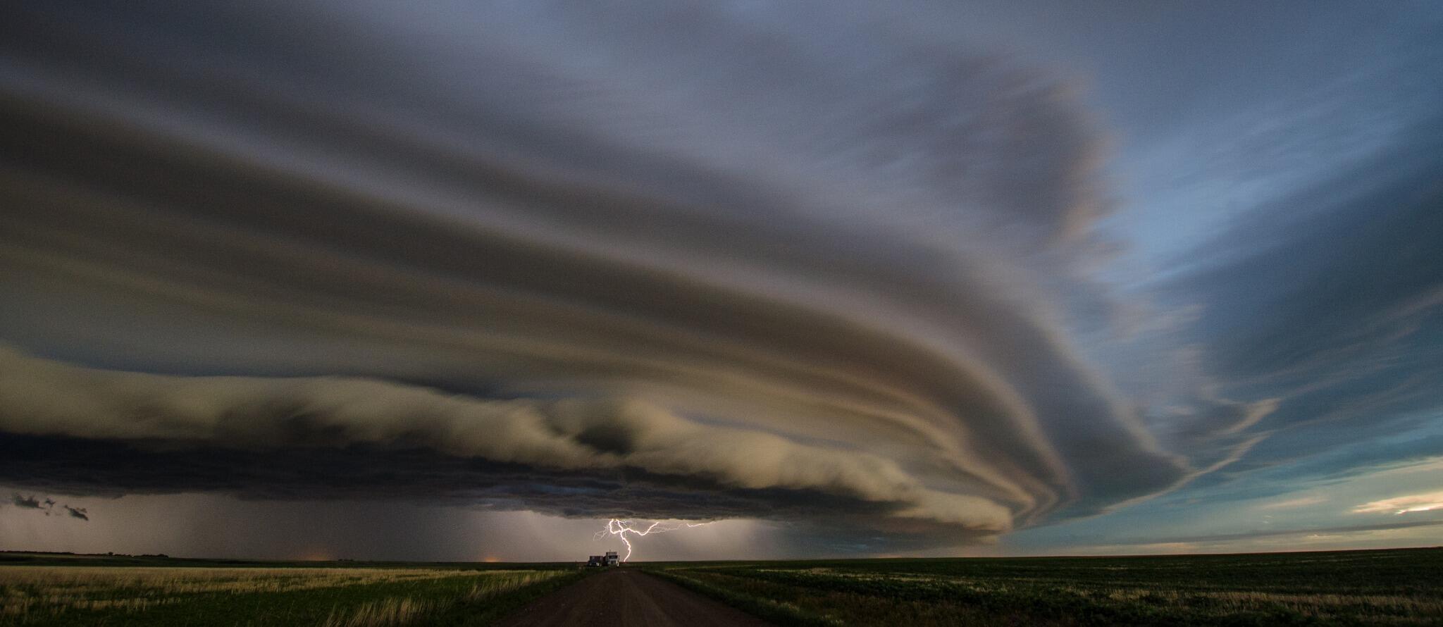
Spectacular image of shelf cloud with thunderstorm
approaching Swift Current SK Monday evening.
Severe thunderstorms possible over SW Manitoba
later today.  (image credit @JorBraun) 
It's taken awhile.. but it looks like Winnipeg could be seeing its first 30C reading of the year today as a warm front along the US border lifts north today, tapping very warm and humid air from the south. The increasing humidity will result in humidex values rising to the mid 30s this afternoon.. especially over the southern RRV. By this evening, a trof of low pressure pushing into SE Saskatchewan is expected to trigger some strong to locally severe thunderstorms over SW Manitoba with torrential rain, large hail and strong wind gusts as the primary threats. Isolated tornadoes are also possible with initial strong storms that develop.  The thunderstorms are expected to spread into the Interlake and RRV late this evening.. with the potential for heavy rain and strong winds as well as frequent lightning. Welcome to summer!  

UPDATE: A high of 30.7C at YWG airport today.. the first 30C reading of the year.

Wednesday, June 19, 2013

Thunderstorms with heavy rainfall possible Thursday night

An active weather pattern is setting up over the southern Prairies this week, with locally severe thunderstorms likely over southern Alberta and southern Saskatchewan again later today into tonight. The remnants of that convective activity will spill into southwest Manitoba Thursday, with showers and thunderstorms expected to re-develop over southern MB including the Red River valley later Thursday into Thursday night. Some of these thunderstorms may be strong with heavy rain and frequent lightning, with the potential for some locally severe storms giving large hail and strong wind gusts. This activity is expected to push through southern MB by Friday morning, with additional thunderstorms possible later Friday especially over southeast MB and near the US border.

Kenaston Blvd near Sterling Lyon Parkway last evening
photo credit @tracyljk
UPDATE: A nearly stationary thunderstorm cell over southwestern parts of the city dumped torrential rain Thursday evening, with amounts of 50 to 75 mm reported within 2 hours. The heavy rains caused flash flooding on some major routes in Tuxedo and Charleswood and even flooded IKEA and Superstore buildings. See "A Weather Moment" for additional details on this event.     


At my station in Charleswood, I picked up 69 mm of rain between 720 and 920 pm. (see rain accumulation graph left)  Heaviest rain was between 720 and 820 pm when 50 mm fell within one hour, with a peak rainfall intensity of 293 mm/hr at 7:39 pm according to my Davis Vantage Pro weather station. See City of Winnipeg rainfall map that shows the localized nature of this extreme rainfall. 


Sunday, June 09, 2013

More unsettled weather Monday then a drier, warmer week ahead..

Showers and scattered thunderstorms moved across southern Manitoba today as a trough of low pressure from Saskatchewan pushed across the region. This activity is expected to taper off this evening, however another batch of showers and thunderstorms over southern Saskatchewan is forecast to spread into southwest MB overnight into early Monday, pushing into the Interlake regions during the day Monday. Locally heavy downpours are possible with this next wave of precipitation with 10-20 mm possible in some areas. The bulk of the activity is expected mainly west and north of Winnipeg, but the city could also see some showers Monday morning through early afternoon along with a chance of a thunderstorm.

Once that system clears out Monday evening, the rest of the week is looking great.. with generally sunny skies and warm temperatures in the mid to upper 20s through at least Thursday and possibly into Friday before the next threat of showers by the end of the week. Slowly but surely.. it's beginning to feel a little more summer-like in southern Manitoba.    

Saturday, June 01, 2013

Cool start to June with frost risk tonight..

After a soggy end to May, a ridge of high pressure will bring clearing skies and drier weather this weekend over southern Manitoba to start off the month of June. Temperatures however will be below normal, with daytime highs only in the mid teens today and Sunday, some 7C below normal for this time of year. As the ridge builds in over southern Manitoba tonight, clear skies and diminishing winds will give ideal conditions for areas of frost overnight across much of southern Manitoba including Winnipeg. Temperatures will be dropping to the 0 to +2C mark tonight, with a good risk of frost overnight into early Sunday in many areas. Sunny skies and light winds will make for more pleasant conditions Sunday, as afternoon temperatures climb to the 16C mark. Dry weather is expected into early next week before another disturbance brings a threat of more rain by mid week.      

Friday, May 31, 2013

..Soggy end to May over southern Manitoba..

A slow moving storm system over the Dakotas brought another round of heavy rainfall to southern Mnaitoba over the past two days, less than 2 weeks after  a similar rainfall event brought drenching rains to the same area over the Victoria Day weekend. General rainfall amounts of 30 to 60 mm were widespread mainly along and south of the TransCanada highway  with locally heavier amounts  of 80 to 125 mm along the western Red River valley. 

At my site in Charleswood, I recorded a storm rainfall total of 43 mm, while 50 to 70 mm was reported over the south end of the city. La Salle reported 54 mm.  Unofficial reports of 80 to 125 mm were received for areas along the western Red River valley from the Austin and MacGregor areas to west of Miami to the US border. Overland flooding was once again reported in the Morden area due to heavy rains along the Pembina escarpment. This area was flooded over the Victoria day weekend as well with local amounts of 100 to 200 mm of rain during the 3 day rainfall event.   

Rainfall storm totals to 1 am Saturday since the rain began Thursday morning..   
  
ENVIRONMENT CANADA STATIONS  
  
DEERWOOD .................. 81 MM  
MORDEN .................... 69 MM  
PORTAGE LA PRAIRIE ........ 63 MM  
CARMAN .................... 52 MM  
EMERSON ................... 42 MM  
WINNIPEG FORKS ............ 40 MM  
WINNIPEG AIRPORT .......... 38 MM  
PINAWA .................... 37 MM  
GRETNA .................... 36 MM  
GIMLI ..................... 35 MM  
CARBERRY .................. 29 MM  
MELITA .................... 24 MM  
PILOT MOUND ............... 22 MM  
BRANDON ................... 19 MM  
SPRAGUE ................... 13 MM  
MCCREARY .................. 11 MM  
DAUPHIN ...................  6 MM  
  
MANITOBA AGRICULTURE SITES (MAFRI)  
  
TREHERNE .................. 68 MM  
PORTAGE LA PRAIRIE EAST ... 67 MM  
RESTON .................... 56 MM  
CARMAN .................... 55 MM  
STARBUCK .................. 54 MM  
WINKLER ................... 53 MM  
MORRIS .................... 49 MM  
ST ADOLPHE ................ 42 MM  
MANITOU ................... 42 MM  
LETELLIER ................. 41 MM  
DELORAINE ................. 41 MM  
GLADSTONE ................. 39 MM  
ST PIERRE ................. 37 MM  
ELM CREEK ................. 37 MM  
ALTONA .................... 36 MM  
SELKIRK ................... 30 MM  
STEINBACH ................. 26 MM

Sunday, May 26, 2013

Unsettled week ahead..

The weather pattern will be getting more unsettled over southern MB this week as an upper ridge of high pressure starts building over eastern North America, while a long wave upper trof sets up over the west. This will set up a storm track across the northern Plains and southern Prairies this week, with periodic weather systems bringing occasional rounds of showers and possible thunderstorms.  The first wave of precipitation is expected this afternoon into tonight over southern MB as a band of showers over North Dakota spreads northeast. Another impulse over the Dakotas will threaten more showers and possibly thunderstorms over southern MB later Monday through Monday night into early Tuesday with locally heavy rain possible. Drier weather is expected midweek before a more potent system developing over the Dakotas brings more showers and thunderstorms later in the week. Overall, not the greatest week if you're looking for a prolonged stretch of sunny warm weather!  But then, this is not unusual for this time of year. On average, June is the wettest month of the year over southern MB, as increasingly warmer and more humid air to our south tries to spread north, and interacts with weather system crossing the Prairies.     

Wednesday, May 22, 2013

Nice dry weather for the rest of the week..

After a soggy holiday weekend that dumped 15-50 mm of rain over Winnipeg, and up to 200 mm over the Pembina escarpment west of Morden,  the weather pattern will be a lot drier this week as a ridge of high pressure builds in over the eastern Prairies. This ridge will bring mainly sunny skies and near normal temperatures for the rest of the week, along with low humidity and diminishing winds.. perfect conditions for drying out left over moisture from the weekend. The next chance for rain will be Saturday as a weakening band of showers from Saskatchewan pushes across southern MB. At this point, it looks weak, and the current forecast of "periods of rain" for Saturday looks overly pessimistic.

May 18-20 weekend rainfall totals..  

Winnipeg
north end....... 15 mm
Airport ......... 18 mm
Forks ............ 24 mm
Charleswood ... 27 mm
Norwood ........ 31 mm
South Winnipeg ... 30-50 mm

Thornhill .............  205 mm
Darlingford .......... 200 mm
Miami 10SW ...... 125 mm
Morden 6SW ...... 120 mm
Deerwood ........... 100 mm
Morden ...............  90 mm
Somerset .............  80 mm
Winkler ...............  77 mm
Manitou ............... 76 mm
Sprague ............... 73 mm
Carman ................ 68 mm
Emerson .............. 55 mm
Morris.................. 54 mm

Note the heaviest amounts over the western Red River valley along the Pembina escarpment. A persistent northeast upslope flow through the weekend contributed to the locally higher amounts in that area, leading to overland flooding. Note that similar amounts were reported along the escarpment in neighbouring North Dakota with reports of up to 225 mm near Walhalla. This has forced the evacuation of the town of Cavalier, ND due to concerns about a nearby dam failing.

Friday, May 17, 2013

Unsettled weekend.. locally heavy rain possible at times.. but rain-free periods as well

3 day precipitation outlook (Fri - Mon)
from HPC, amounts in inches
showing heaveist rain of 75+ mm
south of the US border
A complex weather pattern will be setting up over the Northern US plains this weekend,  which will be impacting the weather over southern MB for the May long weekend.  A series of disturbances will be triggering showers and scattered thunderstorms over North Dakota and northern Minnesota over the the next few days, some of which may bring areas of heavy rain to southern MB.  Models however are having a tough time coming to a consensus as to when and where most of the precipitation will be falling over southern MB. It appears there will be an initial band of showers and thunderstorms developing tonight over North Dakota and spreading into southern MB overnight into Saturday, with the potential for locally heavy rain in showers or scattered thunderstorms.  On Sunday, a stronger system developing over South Dakota will move into northwest Minnesota, triggering more widespread showers and thunderstorms south of the border. This area of precipitation is expected to push over southeast MB Sunday night into Monday, although models having varying opinions on how far northwest this second wave of showers will spread. Some models are indicating that most of the heaviest precipitation will stay over extreme southeast MB and miss Winnipeg and the RRV. Other models are indicating that showers will push into Winnipeg and the southern Interlake by holiday Monday. Thus, the forecast for the latter half of the holiday weekend is still in doubt. Bottom line: not the best holiday weekend, but not a total washout either. Note however, that the potential for locally heavy rain (50 mm or more) is possible this weekend for parts of southern MB including the Red River valley.  (Consult  HPC precipitation forecasts for updated trends on expected precipitation patterns this weekend) 

Sunday, May 12, 2013

Warmer week ahead..

After a rather cool weekend, warmer weather is on tap for southern Manitoba this week, as temperatures climb back into the 20s. Strong southerly winds gusting to 60 or 70 km/h Monday morning in Winnipeg and the Red River valley will signal the start of the warmup, with temperatures climbing into the low to mid 20s in the afternoon as winds shift into the west.  On Tuesday morning, a disturbance crossing southern Manitoba will bring an area of showers across the Red River valley, with the slight chance of an isolated thunderstorm in spots. This unsettled weather will move through by late Tuesday with generally dry and seasonable  weather for the balance of the week, with daily highs in the low 20s.  Unsettled weather is likely to return by Friday, with models indicating the potential for a stronger system affecting southern Manitoba by Sunday or Monday with heavy rain possible. The warmer weather along with some moisture and higher dewpoints will hopefully help accelerate leaf budding this week, which is still behind normal due to the prolonged winter and delayed spring this year.   

Powerful wind gusts drive ice floes on Dauphin Lake onshore damaging cottages, homes..

Wind driven ice floes swallow up cottages in
Ochre Beach, MB - May 10 2013
Powerful northerly winds gusting up to 80 km/h over western Manitoba pushed ice on Dauphin Lake onto the south shore of the lake late Friday, damaging or destroying over 2 dozen waterfront homes and cottages in Ochre Beach, MB.   The ice was pushed up 20-30 feet, crushing cottages in its relentless path onshore. Luckily, no one was injured during the late day event, which witnesses report took only 15 minutes to occur, some describing it as an "ice tsunami". See CBC news story  as well as Winnipeg Free Press story on "ice shove" phenomena with more great photos.   

What happened?

Foxwarren radar just before 6 pm
showing showers with strong
outflow winds approaching
Ochre Beach
Friday May 10th was a fairly windy day over western Manitoba with gusty northerly winds of 40 to 60 km/h behind a cold front that had pushed through earlier in the day. By afternoon, an area of convective showers had developed over central Manitoba and was pushing down over western MB from the northwest. At around 6 pm, radar was detecting an area of showers spreading over the north part of Dauphin Lake heading south towards Ochre Beach. At the time, Dauphin airport was reporting a temperature of 10C with a dewpoint of -4C, indicating dry air in the low levels. At 6:16 pm as the showers were starting to pass through, winds at Dauphin airport suddenly starting gusting to 75 km/h (41 knots) with a peak gust of 80 km/h (43 knots) at 6:22 pm (2322Z)  (see observations below)  These winds were indicative of strong "downburst winds" caused by convective showers tapping strong winds aloft (80-90 km/h) and spreading them down to the surface (note also strong pressure rises reported at the time, characteristic of strong winds pushing down).  It is likely during this time that the lake ice was driven onshore by the fairly brief but powerful wind gusts. Note that the lake ice was fractured and crystallized owing to the lateness of the season, which made it easier for strong winds to push the ice floes onshore.

Dauphin Airport AWOS observations -  18-00Z May 10 2013 

CYDN 101800Z AUTO 36021G29KT 9SM FEW036 10/00 A3007 RMK MAX WND 35023KT AT 1750Z SLP192
CYDN 101900Z AUTO 35023G34KT 9SM CLR 12/M04 A3008 RMK MAX WND 35028KT AT 1853Z SLP193
CYDN 102000Z AUTO 01020G33KT 9SM CLR 12/M05 A3009 RMK MAX WND 36028KT AT 1938Z SLP199
CYDN 102100Z AUTO 01023G32KT 9SM FEW075 13/M06 A3010 RMK MAX WND 01027KT AT 2023Z SLP201
 CYDN 102200Z AUTO 33016G23KT 9SM FEW080 BKN098 12/M06 A3011 RMK MAX WND 36025KT AT 2101Z SLP203
CYDN 102300Z AUTO 02017G23KT 9SM SCT070 BKN087 BKN110 10/M04 A3013 RMK MAX WND 35022KT AT 2214Z SLP211
CYDN 102316Z AUTO 35032G41KT 9SM BKN060 BKN074 OVC088 08/M00 A3015 RMK MAX WND 35032KT AT 2316Z PRESRR SLP221
CYDN 102322Z AUTO 35031G43KT 9SM -RA FEW033 SCT050 BKN065 OVC080 06/02 A3017 RMK MAX WND 35036KT AT 2317Z PRESRR SLP228
CYDN 102359Z AUTO 36013G19KT 9SM SCT025 BKN060 OVC081 05/02 A3019 RMK MAX WND 35036KT AT 2317Z PRESRR SLP234CYDN 110000Z AUTO 36014G19KT 9SM SCT025 BKN065 OVC075 05/02 A3019 RMK MAX WND 35036KT AT 2317Z PRESRR SLP235

Lake ice comes onshore off Mille Lacs Lake in northern Minnesota - May 11 2013

Amazingly, the exact same phenomena occurred the very next day, May 11th, on a lake in northern Minnesota, Mille Lacs Lake, east of Brainerd, with strong winds pushing lake ice onshore causing damage to a lakeside home there.  (see video below)      


Tuesday, May 07, 2013

Cooler weather on the way..

After 2 days of summerlike temperatures in the mid 20s, things will be cooling off noticeably Wednesday as a cold front pushes through southern Manitoba, with brisk northerly winds ushering in temperatures some 10-15C cooler than the past couple of days.  The cold front will be pushing through Winnipeg after midnight tonight, with northerly winds increasing to 30 gusting 50 km/h behind the front. Temperatures Wednesday will be struggling to get much above 10C, which will feel even cooler with the wind, with below normal temperatures lingering into Thursday. Friday will see a bit of moderation as we get back into a southerly flow of milder air, however another cold front will be pushing through Friday evening ushering in even cooler air for the start of the weekend.  Warmer weather with temperatures back in the 20s is expected by Monday over southern Manitoba.

Thursday, May 02, 2013

A nice improving trend through the weekend into next week..

After a wintery-like start to the month, things will be improving nicely over southern MB over the next few days with mainly sunny skies and warming temperatures through the weekend into the beginning of next week.  Temperatures will climb to the 10C mark Friday, still about 7C below normal, but feeling a lot nicer with sunny skies and light winds. The weekend looks beautiful with sunny skies, light winds and temperatures climbing to seasonal values of 17C by Sunday. Even warmer weather is expected early next week with temperatures climbing into the low 20s for the first time this spring.. a much anticipated warming trend for winter-weary Manitobans.  

April 2013 coldest since 1907.. 3rd coldest on record in Winnipeg 

Temperature graph
Winnipeg - April 2013
showing persistent
cold during the month
April 2013 was the coldest April in over a century in southern Manitoba. The average monthly temperature at Winnipeg airport was a March-like -2.1C, over 6C below normal, and tying April 1907 as the 3rd coldest April in Winnipeg since records began in 1872.  Every day but three were below normal, with a staggering 46 day streak of below normal temperatures from March 10th to April 25th.  The month featured the latest date ever for Winnipeg to hit the +5C mark (April 24th), and the second latest date to hit +10C (April 26th)  Snow cover in Winnipeg, which began back on Nov 10th, did not completely melt until April 26th.. one of the latest snow melts in city history. Luckily, precipitation was fairly normal for the month, and together with a long gradual melt allowed for a reduced flood threat over the Red River valley,   


Top 5 coldest Aprils in Winnipeg (since 1872)

1. 1893 ........  -2.9C
2. 1874 ........  -2.7C
3. 2013 ........  -2.1C
    1907 ........  -2.1C  (tied)
5. 1950 ........  -1.6C
    1996 ........  -1.6C  (tied)

Tuesday, April 30, 2013

Storm system brings signifficant rainfall to Red River valley, late season snowfall through western MB/Interlake regions..

Snow north of Plumas MB
near McCreary
credit: @TLCourt
An energetic storm system tracking across the northern US plains into Northwest Ontario brought significant precipitation over Southern Manitoba over the past 36 hours. Over the Red River Valley and Southeast Manitoba, precipitation fell mainly as rain with some locally heavy amounts up to 20 to 30 mm overnight into this morning. Further north.. temperatures were colder and precipitation fell mainly as snow last night through today. Significant accumulations were reported especially over Western Manitoba along the eastern slopes of the Riding mountains in the Dauphin and McCreary areas where snowfall amounts in excess of 30 cm were reported.

The following are unofficial rain and snowfall reports over the past 24 to 36 hours.
Rainfall reports over past 36 hours to 7 PM...

Winnipeg Airport ......... 19 mm
Winnipeg forks ........... 23 mm
Emerson .................. 16 mm
Pinawa ................... 29 mm
Sprague .................. 27 mm
Steinbach ................ 21 mm
Portage la Prairie ....... 15 mm
Morris ...................  8 mm
Morden ...................  7 mm
Gretna ...................  7 mm
Carman ...................  4 mm
Brandon Airport ..........  5 mm

Snowfall reports to 7 PM.. (estimates)

Dauphin ................. 20-30 cm
McCreary ................ 30-40 cm
Ste Rose Du Lac .....  35-45 cm
North of Plumas ........ 35-45 cm
Langruth ................... 35 cm