The wet finish to the month was in sharp contrast to a dry July and first half of August which saw below normal precipitation in Winnipeg. Temperature-wise, August will finish with an average temperature around 19.3C at YWG airport.. slightly above the average August temperature of 18.8C.
Sunday, August 31, 2014
Soggy end to wet but warm August..
It was a wet finish to the month of August over Winnipeg and the Red River valley as another weather system brought widespread rain to southern Manitoba today. In general about 15-25 mm of rain fell in most areas, with 20 to 40 mm over parts of the southern RRV and southwest MB. In Winnipeg, the official rainfall at the airport today was 18 mm, with 17 mm falling at the Forks. At my location in Charleswood, I picked up 21.6 mm today bringing my monthly total to 137 mm.. well above the August average of 77 mm. The bulk of this month's rain has fallen over the past 2 weeks, with a couple of significant rainfalls across the city including August 21st when a slow moving thunderstorm complex dumped 50-100 mm over the southwest to central parts of the city. Officially, the airport recorded 104 mm this month, while the Forks had 133 mm with amounts over 170 mm from the Tuxedo to Linden Woods area.

Saturday, August 23, 2014
Areas of heavy rain tonight into Sunday morning.. severe thunderstorm risk Sunday afternoon/evening
 |
| WPC 48 hr rainfall forecast (inches) through Monday 70-80 mm noted through Interlake and western MB with 30-50 mm over the RRV including Winnipeg |
 |
| EC Summary of rainfall amounts over weekend |
Friday, August 22, 2014
Torrential rains swamp Winnipeg
 |
| 6 pm radar shows nearly stationary thunderstorm complex over SW Winnipeg into downtown core |
 |
| In one of the more popular images from Thursday's deluge, a resident snorkels in floodwaters in Whyte Ridge (SW Winnipeg) where 80 mm of rain fell in 90 minutes. |
 |
| Flooded underpass at Higgins Ave.. one of several underpasses that were flooded in Thursday's deluge |
 |
| For some, a canoe offered a better mode of transportation on flooded city streets |
Select rainfall amounts from Thursday's deluge.. (unofficial)
 |
| Rainfall amounts over south Winnipeg from WeatherFarm mesonet |
Whyte Ridge ............ 81 mm
U of Winnipeg .......... 65-75 mm
Tuxedo .................... 70 mm
Waverly South ......... 70 mm
Grant Park ............... 65 mm
Linden Woods ......... 56 mm
Forks (EC) .............. 53 mm
Charleswood ............ 41 mm
St Vital .................... 25 mm
Winnipeg airport ....... 19 mm
Transcona .............. 5 mm
This was the second time this week that the Tuxedo to Linden Woods area has been hit with heavy rainfall. On Monday afternoon, a narrow band of heavy showers and thunderstorms dumped 35 to 50 mm along this swath. Tuxedo Park school recorded 49 mm Monday with another 70 mm Thursday, for a total of 119 mm within 4 days. Linden Woods has recorded 109 mm since Monday. Normal August rainfall is 77 mm in Winnipeg.
City of Winnipeg rainfall - Aug 21 2014 (between 4 and 10 pm)
 The following is a map from the city of Winnipeg showing the distribution of rainfall in the city from Thursday's rainstorm. One can see the heaviest rain axis stretching from the southwest Perimeter into the downtown core up towards North Kildonan. The maximum was in the Whyte Ridge area which saw over 80 mm of rain between 530 and 730 pm. (NOTE: The Fort Whyte station recorded an erroneously low number on this map due to a plugged gauge) The city has a network of over two dozen rain gauges scattered throughout Winnipeg to monitor rainfall within the city, which can vary widely in short distances during convective storms (which is the primary mechanism for precipitation in the summer months here) This network of stations helps give the city a much more detailed picture of rainfall distribution within Winnipeg, compared to only 2 official Env Canada sites in the city (Winnipeg airport and The Forks) Link to City of Winnipeg rainfall map.
 Monday, July 14, 2014
Nice warming trend this week.. risk of thunderstorms over weekend
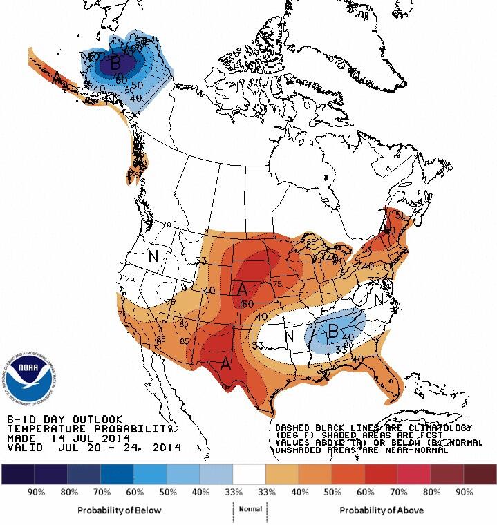 |
| CPC 6-10 day outlook valid Jul 20-24 indicates return of warmer air over southern MB |
Wednesday, July 09, 2014
Seasonably warm weather ahead.. but another cool outbreak Sunday into early next week as heat wave builds over BC
 |
| Looking for heat over the next week? Head west! CPC 6-10 day outlook looks cool for southern MB/Ontario. |
Subscribe to:
Posts (Atom)