Sunday, January 28, 2007
Another Arctic blast by late week
Temperatures will remain seasonably cold for the next few days over Southern MB with highs generally in the minus teens and lows in the minus 20s. Long range guidance however is indicating another shot of very cold Arctic air that is expected to flood into the Prairies by Thursday or Friday (Feb 1-2) that will bring daytime highs in the minus 20s and lows in the minus 30s along with dangerous wind chill values in the minus 40s. The bitter cold is expected to persist through next weekend into early next week after which a moderating trend is expected.

Wednesday, January 24, 2007
Colder air set to return by Friday
 850 mb prog - 6 am Friday morning
Enjoy the relatively mild weather today and tomorrow.. because things are going to get colder again starting Friday. A storm system moving across the northern Prairies over the next couple of days will sweep a cold front across southern Manitoba early Friday morning. Gusty northwest winds behind the front will draw colder Arctic air across the region, with temperatures falling Friday into the minus teens by afternoon. The cold air will become well entrenched over the weekend with highs only around minus 20 and lows in the minus 30s. Temperatures are expected to remain below normal next week into early February as a strong upper ridge over the West Coast gives mild weather over the west while a deep upper trough over Eastern Canada maintains cold air over central and eastern Canada.
Tuesday, January 23, 2007

Thursday, January 18, 2007
CPC forecasting milder than normal conditions into February
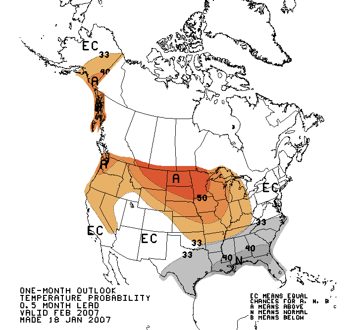
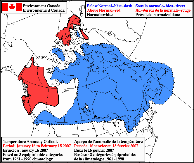 The latest 30 day outlooks from CPC (US Weather Service) have been issued, and they continue to show a better than even chance of milder than normal temperatures for February over the Prairies (top image). In fact, CPC's 6-14 day outlooks are also calling for milder than normal weather for us to finish off January, so the recent cold snap we just went through may be the worst of it this month, or even this winter. (However, cold snaps will still occur, even if the overall pattern is milder than normal.. so don't put away that block heater just yet!)
The milder than normal conditions expected over the next month or so is again in sharp contrast to Environment Canada's latest 30 day outlook (lower image) which calls for below normal temperatures across much of the country into mid February ( a complete flip from their above normal forecast issued two weeks ago). This is not surprising given the the outlook was issued during our mid January cold snap, and EC's outlooks are heavily weighted to current weather patterns. They are also completely automated model-driven products with no human intervention whatsoever. As a result, EC's outlooks tend to be more of a persistence forecast (what's happening now will continue to happen) and can be poor indicators of any major pattern changes expected within the next 30 days. In contrast, CPC's outlooks have a great deal of human involvement in them, looking at overall climate patterns and influences in the near and mid terms, which can lead to more accurate long range outlooks.
Personally, I think the overall weather pattern over the next 30 days is going to favour milder than normal conditions over western Canada with below normal temperatures over Eastern Canada as the NAO turns negative and maintains a large scale trough along the eastern seaboard. For southern MB, this will mean a battle of two airmasses.. alternating between milder Pacific airmasses that will occasionally move in from the west while Arctic intrusions from the north give periods of below normal temperatures. Overall temperatures may be close to normal over the next 30 days, but perhaps more variable with mild and cold episodes balancing each other out.
Monday, January 15, 2007
Warming up by Wednesday.. then colder again
It's another frigid morning over Southern MB with temperatures of minus 30 to minus 35 in Winnipeg this morning (-34 at my Charleswood station) Luckily winds are light today, so windchills are not a factor. Still, even walking at these temperatures will be enough to give exposed skin frostbite within a few minutes.. so bundle up!
Temperatures will start to moderate beginning tomorrow, with noticeably milder conditions on Wednesday with highs climbing back into the minus single digits by then (break out the sunscreen!) Before that however, we will have to deal with a blustery Tuesday as gusty south winds begin developing ahead of the milder airmass. So don't be fooled by Tuesday's forecast high of minus 10.. that's quite misleading as to what kind of day it will be. First of all, that high of -10 (if we even reach it) won't be reached until late in the day or evening. Temperatures will be in the minus 20s all morning and in the minus teens all afternoon. Second, those gusty southerly winds of 40 to 50 km/h with higher gusts will add a significant wind chill.. minus 35 to minus 40 in the morning moderating to minus 25 to minus 30 in the afternoon. In fact, Tuesday will feel just as cold as today even though actual temperatures are a good 10 degrees colder today (but winds are light.. it's all about the wind!)
Unfortunately, the milder temperatures on Wednesday will be short lived as colder air moves in again by the end of the week. Beyond that, temperatures are expected to remain generally below normal for the rest of January with occasional brief warm ups as a large scale upper ridge builds over the west coast, while an upper cold trough digs over Ontario and eastern Canada. This will give a northwest flow over the Prairies that will give Southern MB generally below normal temperatures for the next couple of weeks.
Temperatures will start to moderate beginning tomorrow, with noticeably milder conditions on Wednesday with highs climbing back into the minus single digits by then (break out the sunscreen!) Before that however, we will have to deal with a blustery Tuesday as gusty south winds begin developing ahead of the milder airmass. So don't be fooled by Tuesday's forecast high of minus 10.. that's quite misleading as to what kind of day it will be. First of all, that high of -10 (if we even reach it) won't be reached until late in the day or evening. Temperatures will be in the minus 20s all morning and in the minus teens all afternoon. Second, those gusty southerly winds of 40 to 50 km/h with higher gusts will add a significant wind chill.. minus 35 to minus 40 in the morning moderating to minus 25 to minus 30 in the afternoon. In fact, Tuesday will feel just as cold as today even though actual temperatures are a good 10 degrees colder today (but winds are light.. it's all about the wind!)
Unfortunately, the milder temperatures on Wednesday will be short lived as colder air moves in again by the end of the week. Beyond that, temperatures are expected to remain generally below normal for the rest of January with occasional brief warm ups as a large scale upper ridge builds over the west coast, while an upper cold trough digs over Ontario and eastern Canada. This will give a northwest flow over the Prairies that will give Southern MB generally below normal temperatures for the next couple of weeks.
Subscribe to:
Posts (Atom)