Saturday, September 01, 2012
Showers/thunderstorms possible tonight.. clearing and warmer for remainder of holiday weekend. Cooler conditions for back to school..
A warm front along the international border will push northward across southern Manitoba tonight bringing a threat of showers and thunderstorms, mainly across the south this evening pushing into the Interlake areas overnight. This activity will move into northern Manitoba and northwest Ontario Sunday morning, with a clearing trend over southern Manitoba. This will allow temperatures to rise to the 30C mark once again over the Red River valley with sunshine and a southwest breeze. Sunny and warm conditions are expected to continue into holiday Monday with temperatures again near the 30C mark. Cooler conditions are forecast for the remainder of the week as an upper trof pushes across the Prairies, with temperatures more typical for early September (highs near 21c) along with partly cloudy skies and a threat of showers by mid week.

Warm end to August continues above normal streak.. summer of 2012 ends up as 10th warmest/driest on record in Winnipeg
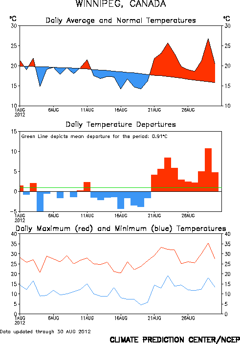 |
| Daily temperature summary for Winnipeg - August 2012 |
As a whole, the summer of 2012 finished with an average temperature of 19.8C for the 3 month period of June, July and August, about 1.5C above normal. This makes the summer of 2012 the 10th warmest on record in Winnipeg, tied with 4 other summers (1919, 1921, 1936 and 2006) Records for Winnipeg started 140 years ago in 1872.
Top 10 warmest summers in Winnipeg (since 1872)
1. 1988 ....... 21.0C
2. 1983 ....... 20.6C
3. 1961 ....... 20.4C
4. 1955 ....... 20.2C
5. 1930 ....... 20.1C
5. 1963 ....... 20.1C
7. 1933 ....... 19.9C
7. 1995 ....... 19.9C
7. 1991 ....... 19.9C
10. 1919 ....... 19.8C
10. 1921 ....... 19.8C
10. 1936 ....... 19.8C
10. 2006 ....... 19.8C
10. 2012 ....... 19.8C
Normal summer average ... 18.4C (1981-2010 average)
 |
| Summer rainfall in Winnipeg June-August 2012. A wet start to the summer turned dry by late June |
Top 10 driest summers in Winnipeg (since 1872)
1. 1929 ......... 76.7 mm
2. 1886 ......... 77.2 mm
3. 1961 ......... 91.0 mm
4. 2006 ......... 91.5 mm
5. 2011 ......... 93.0 mm
6. 1889 ......... 96.0 mm
7. 1894 ......... 97.1 mm
8. 1915 ......... 114.8 mm
9. 1936 ......... 121.4 mm
10. 2012 ......... 129.5 mm
Normal summer rainfall .... 247.5 mm (1981-2010 average)
For additional data and analysis of the warmth this year, consult "A Weather Moment" website.
Wednesday, August 29, 2012
Temperatures soar into mid to upper 30s over southern Manitoba
It was a record hot day over parts of southern Manitoba Wednesday as a brisk southerly flow pumped in some of the hottest air of the summer into the region. Temperatures soared into the mid to upper 30s over the Red River Valley and SW Manitoba, the 20th day this summer with highs of 30c or more in Winnipeg (normal is 13) Winnipeg's high of 35.4C tied July 29th as the hottest day of the year in the city, while temperatures soared to a record 36.9C in Brandon and 37.9C in Dauphin, the hottest spot in the country. Even hotter temperatures were recorded south of the border, including 40C in Minot, ND and 44C in Chamberlain, SD. A cold front pushing though tonight will usher in cooler but still above normal temperatures for Thursday and Friday with highs in the mid 20s, before another shot of 30c weather for Saturday.
Record temperatures across southern Manitoba Wed Aug 29...
Record temperatures across southern Manitoba Wed Aug 29...
                          New      old       record    records
Location               record   record    year    began
--------------------------------------------------------
Brandon                36.9     36.7      1972    1890
Dauphin                37.9     35.6      1972    1891
Fisher Branch         34.6     32.0      1991    1977
Melita                   36.1     30.1      1996    1993
Pilot Mound            35.5     35.0      1961    1938
Pinawa                  33.4     33.0      1991    1964
Portage la Prairie     36.6     35.6      1972    1886
Sunday, August 26, 2012
After a cooler weekend, another shot of 30C heat coming this week.. along with more dry weather
The summer of 2012 is hanging on in southern Manitoba as August draws to a close. After 3 days in the 30s in Winnipeg last week, the weather turned breezy and a little cooler over the weekend, albeit with temperatures still quite pleasant near the 25C mark.. which is still slightly above normal for the end of August.(normal high of 23c now) More fine weather is in store this week as high pressure drifts over southern Manitoba, bringing clearing skies and light winds on Monday with highs near 26C. The heat will be moving in again by midweek as an upper ridge of high pressure builds over the eastern Prairies once again, with southerly winds pushing temperatures over the 30C mark by Wednesday. In fact, there's a potential for 35C temperatures Wednesday over the Red River valley as a very hot airmass pushes into the central continent. (Temperatures of 35-40C are possible over North Dakota Wednesday) Slightly cooler temperatures are expected by the end of the week, but still staying near or slightly above normal.
Those looking for rainfall will be disappointed by the weather this week, with no real prospects of significant rain in the near future. Things have turned quite dry over southern Manitoba over the past couple of weeks, after a somewhat unsettled first half of the month that saw some significant rainfall at times. Even so, Winnipeg has seen only 43 mm of rain this month, just over half the average August rainfall of 75 mm. This will be the third month in a row with below normal precipitation in Winnipeg, with 130 mm of rain recorded since June 1st, just over half the summer average of 235 mm. This comes on the heels of last year's dry summer, which ranked as the 5th driest summer on record in Winnipeg with only 93 mm of rain for the 3 month period of June, July and August.
Tuesday, August 21, 2012
30C weather returns to southern Manitoba..
Summertime weather will be hanging on this week as an upper ridge gradually pushes across the Prairies. Temperatures climbed into the 30s south and west of Winnipeg Tuesday (including 33.5C in Emerson), while Winnipeg hit a of high of 29.2C. Winnipeg has yet to hit 30C this month after hitting the mark 14 times in July.. however it looks like the city will be seeing 30C temperatures Wednesday into Friday as the warm air continues to spread north and east. Conditions will be generally sunny and hot, however there is a chance of some showers or thunderstorms Thursday evening as a weak upper impulse moves across southern Manitoba. A more significant cold front is expected to cross southern Manitoba Friday night bringing in cooler conditions for the weekend.
30C days in Winnipeg (annual total)
2012 ...... 21 (updated Aug 31)
2011 ...... 24
2010 ...... 11
2009 ...... 4
2008 ...... 5
2007 ...... 13
2006 ...... 24
Normal .... 13
Record high ... 34 (1988, 1961)
30C days in Winnipeg (annual total)
2012 ...... 21 (updated Aug 31)
2011 ...... 24
2010 ...... 11
2009 ...... 4
2008 ...... 5
2007 ...... 13
2006 ...... 24
Normal .... 13
Record high ... 34 (1988, 1961)
Subscribe to:
Posts (Atom)