Monday, December 19, 2016

After the big chill, a nice break from the cold this week..

After a brutally cold weekend that saw temperatures drop to the minus 30C mark and windchills of -40 or lower, southern MB awoke to a different world this morning as temperatures soared into the minus single digits by 8 am.. a difference of +25C from 24 hours earlier. In Winnipeg, the temperature at 8 am was -4C, after being -30C at 8 am Sunday, the 18th greatest temperature rise within 24 hours in Winnipeg since 1953. Southwest winds ushered in a milder Pacific airmass over southern Manitoba overnight, flushing out the Arctic air that had been entrenched over the area since Dec 9th. And the good news is the above normal temperatures should continue the rest of the week, allowing for a pleasant lead up to the Christmas holidays. A couple of fast moving clipper systems will bring an occasional coating of snow (2-4 cm) both today and Wednesday, but overall, no major system are expected to impact southern Manitoba this week.  

Greatest temperature rises within 24 hrs in Winnipeg since 1953
Data courtesy of @jjcwpg


Potential winter storm for Christmas Day/Boxing Day?

The  benign weather pattern may come to end over the Christmas holiday weekend as long range models are indicating the potential for a strong winter storm to move across the northern Plain states and/or northern Minnesota by Christmas Day or Boxing Day. It's much too early to say if this storm will impact southern Manitoba and how badly, but there's growing consensus that a major storm system will be tracking across the northern Plains sometime over the Christmas/Boxing Day period. At this point, all we can say is to keep an eye on this potential winter storm that could be impacting holiday travel in southern MB (especially RRV and SE MB) depending on how it tracks. Realize however that models will be jumping around on the possible solutions on this storm system over the next few days until they get a clearer picture of where this storm will track. Stay tuned..

Wednesday, December 07, 2016

After the big dig, comes the big chill!

Residents of Winnipeg and southern Manitoba are digging out after a major winter storm brought heavy snow, high winds and blizzard conditions to much of the Red River valley Tuesday into Wednesday.  In Winnipeg, the storm dumped 25-35 cm of snow over the 2 days, with strong winds gusting to 70 km/h producing significant blowing and drifting snow. It was the city's worst winter storm in several years.. perhaps one of the worst since the blizzard of April 1997.  The storm was even worse outside the city as powerful winds of 70 to 80 km/h produced blizzard conditions over the western and southern RRV, leading to the closure of many highways including the TransCanada from Headingly to the SK border, Hwy 75 from Winnipeg to Emerson, as well as highways 2 and 3 southwest of the city. 

But now that the storm is ended, there's a new winter hazard to prepare for.. bitter cold. A massive Arctic airmass has settled in over western Canada, and this colder airmass will be be spreading into southern Manitoba over the next couple of days. By Friday, daytime highs are only expected to around -17C with lows in the minus 20s.  This will be the first time in 7 weeks that temperatures will be below normal in southern Manitoba. In Winnipeg for example, the average daily temperature has been above normal since Oct 21st, a streak of 48 straight days as of Dec 7th. This streak will come to an end Thursday as a new streak of below normal temperatures begins. Temperatures will remain well below normal through the weekend into next week, with even colder air moving in for mid week next week. Temperatures may dip to -30C or lower by Dec 14th, mid winter cold we haven't experienced since last winter.   So break out the parkas and get those block heaters ready..  much colder weather is on the way! 

Monday, December 05, 2016

Major winter blast heading for Winnipeg/RRV

HRRR forecast for 6 am Tuesday morning shows
strong winter storm affecting RRV/SE Manitoba 
The first major winter storm of the season is on its way into southern Manitoba as a low pressure system over eastern North Dakota slowly tracks towards the Canadian border. Heavy snow from this system is already affecting northeast North Dakota this evening, and will continue to spread north into southern Manitoba through tonight. Snow is expected to reach the Winnipeg area by 3-4 am overnight and become heavy by the Tuesday morning rush hour. In addition winds will be increasing from the north gusting to 60-70 km/h which will produce poor visibilities in blowing and drifting snow. Give yourself plenty of time to get to school or work tomorrow as road and traffic conditions will be poor. 

Snow will continue through Tuesday into Tuesday night, moderate to heavy times, with 15-20 cm possible by Tuesday evening. The evening commute will be slow and treacherous with double to triple commuting times. Winds will continue strong out of the north with gusts to 60 km/h in Winnipeg, with even higher gusts of 70-80 km/h possible over the western and southern Red River valley. These areas will be most susceptible to blizzard conditions given the strong winds and wide open terrain. Don't be surprised to see road closures on Highway 75 south of  Winnipeg, Highway 1 west of Winnipeg, and highways 2 and 3 southwest of the city. Snow is expected to continue Tuesday night with another 5 cm possible before the storm starts winding down on Wednesday, although blowing and drifting snow may continue to be a problem. All in all, a significant winter storm to usher in much colder weather for the end of the week. After being AWOL in November, winter is making a forceful return in December! Get ready!        

Saturday, December 03, 2016

Mild weather continues into early next week.. then Arctic plunge moves in! Significant snow possible Tuesday.

The above normal temperature pattern which has persisted over southern Manitoba for the past 6 weeks will continue through the weekend into early next week.. but a major pattern change next week will bring an end to the mild weather as a strong push of cold Arctic air floods across the Prairies from the west.  This will bring the first real cold weather of the season to southern Manitoba with temperatures in the minus teens and lows in the minus 20s by the end of the week.. a shocking change from the unusually mild weather we have been experiencing since late October (today will mark Winnipeg's 44th consecutive day above normal since the warm weather streak started Oct 21st). But first we'll have to deal with a minor system passing through southern Manitoba Saturday night into Sunday morning that will bring a couple cm of snow along the way. That will clear out by afternoon with a pleasant end to the weekend as temperatures remain well above normal for early December with highs around the freezing mark (normal highs are now -7C with lows of -16C!)
NAM model valid 3 am Tuesday morning shows potential storm
system over southern Manitoba with widespread snow
causing significant impact to the Tuesday morning commute
Stormy Tuesday?  Things start to get interesting Monday night into Tuesday as a storm system over Montana tracks towards the Red River valley, possibly bringing significant snowfall across southern Manitoba, including Winnipeg. Most models are suggesting that southern Manitoba could be seeing 10-20 cm of snow with this system as well as increasing northwest winds and falling temperatures on the backside of the storm Tuesday. One model however, the Canadian GDPS, is suggesting that the storm will mainly miss southern Manitoba before clipping southeast Manitoba Tuesday night into Wednesday. This solution could easily change over the next few days, so keep up to date on this potential storm system for southern MB that could have significant travel impacts Monday night into Tuesday. Regardless of what happens, be prepared for a big change to significantly colder weather by the middle of next week!     

Friday, December 02, 2016

A November to remember - warmest November on record in Winnipeg and much of Manitoba

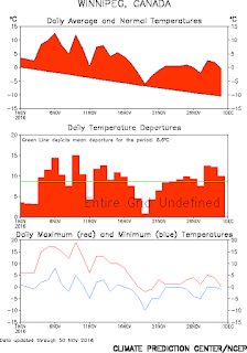
November 2016 will go down as the warmest November in 144 years of records in Winnipeg as a mild pattern that began at the end of October persisted right through the month. In Winnipeg, November ended up with an average monthly temperature of +3.1C, a whopping 8C above the monthly normal of -4.9C, easily beating the previous all time warmest Novembers of 1899 and 1923 at +1.3C. (Records for Winnipeg date back to 1872). Every day of the month was above normal, with an exceptionally mild first half that saw temperatures soar to a record high of 18.8C on Nov 9th.  The main story in November was the notable lack of cold, with only 5 days of the month seeing temperatures of -5C or colder, the fewest such days on record for a November (previous lowest was 7 days in Nov 1899)  Normally, November sees 20 days of -5C or lower, with an average low of -15C by Nov 30th!  The average low during Nov 2016 was an incredible -1.0C, which is just about the normal average HIGH for November (-0.6C)  The lack of cold weather resulted in a delayed start to winter, with the first measurable snow of the season falling on Nov 22nd.. the latest first measurable snow on record in Winnipeg (previous latest was Nov 21 1963) Although a blessing for many, the slow to start to winter was not welcome by all.. especially farmers trying to get work done on still soggy unfrozen fields, and ice fishermen.  For the first time in at least 55 years, there was no ice on Lake Winnipeg as of December 1st. This has caused a significant delay in the ice fishing season and those who rely on ice covered lakes to start winter fishing.

Mean monthly temperatures for November in Winnipeg 1872-2016
November 2016 was by far warmest in 144 year record 

Monthly temperature graph Nov 2016
Every day was above normal

Temperature anomaly map for Nov 2016 shows
core of anomalous warmth was over Manitoba


The list of records set in November in Winnipeg is impressive.  Among the notable milestones..
  • warmest November mean temperature (+3.1C, normal -4.9C)
  • warmest November mean daily maximum (+7.2C, normal -0.6C)
  • warmest November mean daily minimum  (-1.0C, normal -9.2C)  
  • most humid November (average dewpoint +0.3C, first time Nov avg over 0C)
  • 2 daily record high maximums (18.8C on Nov 9th, 13.6C on Nov 12th)
  • 3 record warm daily minimums (7.4 Nov 6, 4.8 Nov 9, 0.1 Nov 24
  • least number of days at or below -5C in Nov  (5 - previous low 7 in 1899)
  • least number of days below 0C in Nov (18 - previous low 20 in 2015)
  • latest date of first measurable snowfall of the season (Nov 22nd)  


The record warm November helped give Winnipeg its second warmest climatological fall on record (Sep 1 - Nov 30) with an average temperature of +8.0C, second only to 1963 (+8.6C) 


Average fall temperatures - Winnipeg (1872 - 2016)
graph credit @jjcwpg 
As of December 2nd, the mild weather pattern was persisting over southern Manitoba, with Winnipeg on its 43rd consecutive day above normal (a streak that started Oct 21st)  However, long range outlooks call for a pattern change to colder weather by the middle of next week.. putting an end to incredible 6 1/2 week run of above normal temperatures across southern MB.