Milder than normal weather is expected to continue over southern Manitoba through the first part of November, with no real signs of winter weather just yet. Temperatures are expected to range some 5-10C above normal for early November with highs of 8-15C through the first week (normal highs for November in Winnipeg drop from +5C on Nov 1st to +1C on Nov 10th) In particular, Thursday Nov 3rd is looking very mild with highs of 15C possible for Winnipeg and southern MB.
Generally dry weather is expected through the period, with the exception of one day.. unfortunately falling on Halloween. A low pressure system is forecast to track across North Dakota next Monday Oct 31st spreading an area of rain across southern MB. This system could bring 10-25 mm over portions of the Red River valley likely starting Monday morning and continuing in the evening before tapering off by midnight. Temperatures will be around +7C Halloween evening.. so conditions will be relatively mild, but wet.
UPDATE: Winnipeg airport recorded 15.8 mm of rain on Oct 31st, making it the city's rainiest Oct 31st on record. The previous rainfall record for Oct 31 was 11.6 mm in 2000. Another 1.7 mm fell early this morning for a storm total of 17.5 mm. Rainfalls of 15 mm or more become less frequent in Winnipeg as we get into November, especially after the first week (see Nov precip records for Winnipeg). But they have occurred as late as December with 21.8 mm on Dec 2nd 1982, and an unusual 15.2 mm on Dec 22 1877 (during the freakishly warmest December on record in Winnipeg) The rainiest November day in Winnipeg was on Nov 17 1918 when an astounding 44.5 mm of rain fell, with 50.9 mm over the 2 day span of Nov 16-17.
WINNIPEG HALLOWEEN WEATHER STATS


Updated forecast for Halloween.. (Winnipeg area)
ReplyDeleteLooks like we'll be seeing some rain move into Winnipeg/RRV Monday morning by 9-10 am which should persist through the afternoon before tapering to some drizzle or mist by 6 pm. Halloween evening should be damp and mild with occasional drizzle or fog patches along with light east winds. Temperatures around +6C with 90-100% humidity. A spooky dark evening to add to the Halloween mood! Rain picks up again by mid to late evening as a band of wrap around precipitation moves in from the west.. with another 5 mm or so Monday night before it moves out by 4-5 am Tuesday. In total, looks like about 10 mm of rain for the Winnipeg area between 9 am Monday morning and 6 am Tuesday morning.. less to our south, more to the north.
Rob, i've heard that that after a warm start to November, a major pattern change could be in the works for the 2nd half of November
ReplyDeleteWhat are your thoughts on this.
Thanks.
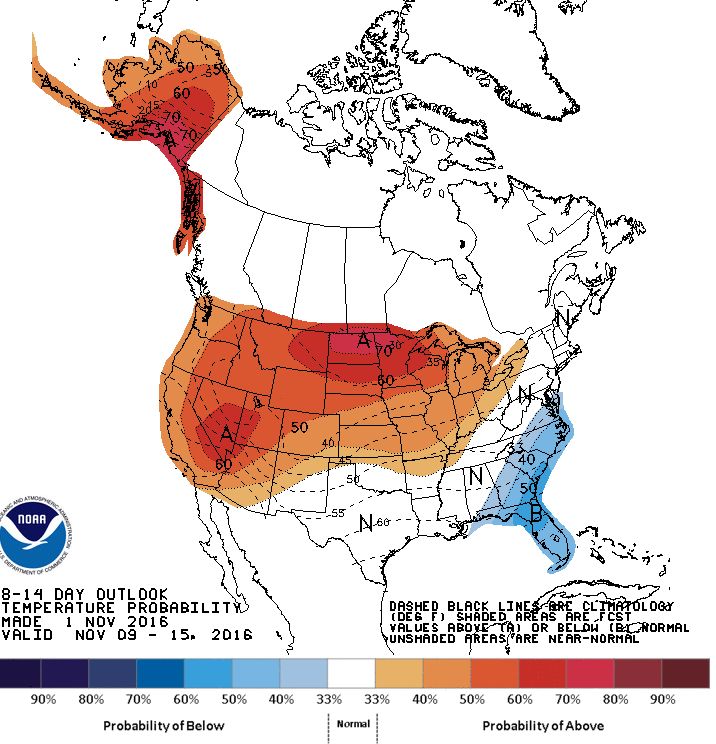
I've been hearing some rumblings about a mid month pattern change to colder weather, but it may be more concentrated over eastern Canada/US. Long range guidance is suggesting a west coast ridge will dominate mid to late month, with upper troughing over eastern NA. This would put southern MB in a NW upper flow which would likely equate to colder temperatures for us, but not necessarily well below normal. It all depends on the strength of those upper features which is hard to say at this point. In the meantime, it looks like we'll be enjoying well above normal temperatures at least through Rememberance Day with no hints of any major cold here for the next couple weeks. In fact, we'll likely be looking at double digits highs for much of the first week of November.. which is pretty amazing. Normal highs for Nov 1st are around +5C lowering to -1C by mid Nov.
DeleteUpdate on our Halloween weather.. latest guidance has about 10-20 mm of rain for Winnipeg through this evening, with a swath of 15-25 mm possible from SW Manitoba (Brandon area) into southern Interlake (Gimli). Lesser amounts of 5-10 mm south and southeast of Winnipeg with only 2-5 mm towards Emerson/US border. Winnipeg has a good shot of seeing its wettest Halloween on record (currently 11.6 mm in 2000)
ReplyDeleteLooks like rain will push into Winnipeg by mid to late morning and continue right through the evening before ending overnight. Rain could ease to some drizzle this evening for awhile but that's more likely to our south. Winds are light this evening but pick up from the northwest by midnight behind the system.
12.5 mm of rain at YWG airport as of 9 pm, officially our wettest Halloween on record. Still raining, so that total will go up until the climatological day ends at 1 am (06 UTC). End of climatological day goes back to midnight when we switch to standard time.
DeleteUPDATE: Winnipeg airport recorded 15.8 mm of rain on Oct 31st, making it the city's rainiest Oct 31 on record. The previous rainfall record for Oct 31 was 11.6 in 2000. Another 1.7 mm fell early this morning for a storm total of 17.5 mm. Rainfalls of 15 mm or more become less frequent in Winnipeg as we get into November, especially after the 10th. But they have occurred as late as early December such as in 1982 when Winnipeg airport recorded 21.8 mm on Dec 2nd.
ReplyDeleteLast cool cloudy day here today before big change to an extended spell of mild weather starting tomorrow. After early morning temps near freezing, temps will start to climb quickly tomorrow with highs of 10-12C in Winnipeg by afternoon as winds shift into the south. That will be the start of an extraordinarily mild spell that will likely persist through Remberance Day according to latest long range guidance. Friday and Saturday look spectacular with sunshine and temps near 15C possible in Winnipeg.. perhaps 18C over parts of the RRV (Morden, Winkler, etc). Sunday will see increasing clouds ahead of a disturbance tracking up from Colorado (no.. not a Colorado low!) This system will bring some rain to southern MB Sunday night into Monday morning with 5-10 mm possible. Temps will continue unseasonably mild in the double digits before a slight cooldown to high single digits on Tuesday behind the system. We then rebound into double digits again Wednesday through Friday next week as another surge of warm air builds over the Prairies. All in all, it looks like southern MB (including Winnipeg possibly) could be seeing double digit highs pretty much every day from tomorrow into Nov 11th. Note that the record longest streak of double digit temps in Winnipeg (highs of 10C or more) for November is 8 from Nov 2-9 1963. If we can squeeze out a double digit high next Tuesday, that streak could be in jeopardy. We'll have to see! Until then, enjoy the upcoming balmy stretch!
ReplyDelete