 |
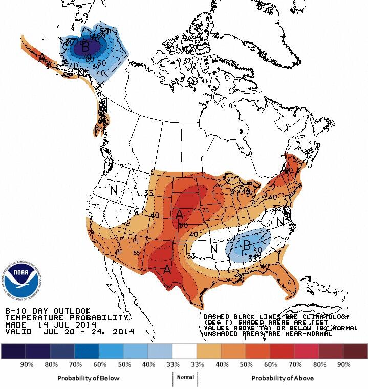
CPC 6-10 day outlook valid
Jul 20-24 indicates return of
warmer air over southern MB |
After a record cool Sunday (max of only 15.7C), temperatures will be on an upswing this week as a deep vortex over Ontario shifts east and weakens. This will allow warm air over western and northern Canada to spread east into southern Manitoba over the next few days, along with plenty of sunshine. Temperatures will climb to 23C Tuesday and reach seasonable highs of 26C by Wednesday. The heat will return for the end of the week with temperatures expected to hit the 30C mark Thursday and Friday. Things get a little more uncertain for the weekend, with models hinting at some showers or thunderstorms by Sunday with increased humidity. After that, indications are that temperatures will climb above normal again for early next week. All in all, looks like a nice taste of summer coming up after a brief flirt with fall Sunday!
Latest model guidance bringing a trough across southern Manitoba Friday bringing some unsettled conditions with scattered thunderstorms likely. Then warm ridge rebuilds over us over the weekend into early next week with temperatures rising into the 30s. So a nice stretch of hot weather on the way, with a brief interruption on Friday with that weak system passing through.
ReplyDeleteQuite the optimistic forecast coming up over the next few days.. nothing but sunshine and 30c+ temps from Friday through Tuesday. Realistically though, there will be some thunderstorm chances over that period, especially Friday and early next week, with a trend towards cooler and more unsettled conditions by mid week next week. But definitely looks hot, especially Sunday when we could be seeing temps up to 34C.
ReplyDeleteModel consensus bringing cold front across southern MB/RRV Friday evening with a few thunderstorms likely, possibly severe. We then cool off a bit Saturday with highs in the mid 20s (that forecast high of 32C from the GLB model is the odd man out and I would discount it) before heating up again Sunday into Monday with temps rising into the low to possibly mid 30s. Things get a little more uncertain after that.. with GLB and GFS indicating a continuation of hot and muggy conditions next week with scattered thunderstorms at times, while Euro shows more of a cooling trend with more unsettled conditions.
ReplyDeleteHazy sunshine today due to smoke aloft from western forest fires. Friday looks warm but windy with gusty south winds to 60 km/h, and a chance of storms possibly severe by evening as weak cold front goes through. Saturday looks a bit cooler (now saying 26C, down from yesterday's 32C) then Sunday looks warm again although there could be increasing clouds and storms ahead of next warm front. Monday now looking like the hottest day of the period, with highs of 32-35C possible. Warm but increasingly unsettled after that as upper flow becomes swly as ridge moves east. This shows the problem with having 7 straight sunny icons in your forecast.. sure doesn't tell the whole story!
ReplyDeleteWill the smoke stick around just for today, or be around the whole weekend??
DeleteIt won't be smoky the whole time, but anytime we get a west or northwest flow aloft over us, we could see some smoky skies here over the next few days. There's a lot of smoke over northern and western Canada that will take some time to clear out. But it's tough to predict how extensive and long lasting that smoke will be. Note that the smoke may hold down our temperatures a couple of degrees since it reduces the strength of incoming solar radiation.
DeleteWinnipeg observer calling this an overcast cirrus layer. In reality, the sky is mainly clear, but with a smoke layer that is obscuring the sky. UV peaked at 3.8 today according to my backyard weather station due to the smoke.. while it peaked at 7 yesterday when it was smoke free. So smoke can act like a cirrus layer in terms of reduced solar radiation and surface heating.
DeleteHello, funnel cloud observation at YWG at 7!
ReplyDeleteSo much for 5 straight sunny days of 30c+ weather. Now it looks like only Sunday may touch 30.. with temps generally around 26 or 27C next week. What does it take to get a nice stretch of sunny hot weather around here?!
ReplyDeleteHey Rob, just curious what are the odds of us getting some severe storms tomorrow? Cold front sliding through (NOAA Wx Map) and high instability values in place, based on the NAM and RDPS.
ReplyDeleteMost guidance showing best threat for severe storms tomorrow will be southeast of Winnipeg towards MN border and south of intl border. We certainly will have the heat and humidity here for storms, but it looks like storms will be firing up later to our south once the front has gone by us. But we'll see.. maybe storms will fire up sooner or front will slow down.
DeleteAnonymous.. These new weather stations are being deployed by the province to help with precipitation monitoring and flood forecasting.. in addition to the stations they already have. They will not be part of EC's network and will not appear on EC's website unfortunately.. But I suspect the data will be available through the Weatherfarm website where the province has several sites already.
ReplyDeleteIt would be nice if EC could get into a data-sharing agreement with these third party networks to make the data more widely accessible.
Okay, thanks for the insight!
ReplyDeleteGFS and Euro indicating the potential for some showers Saturday afternoon into early Sunday, followed by slightly cooler conditions Sunday. So don't be surprised if that sunny warm forecast that is currently being advertised changes somewhat for the weekend..
ReplyDeleteEarlier this year British Tabloids quoted Weather experts as saying despite the enhanced Solar minimum Greatest since the mid 2 nd decade of the 19th century They were confident we would not see another 1815-16 year of no summer. Has anyone checked with Mr Phillips in Toronto. The weather channel keeps talking about the absense of 30° Days this year? How does it compare?
ReplyDeleteHow did the average temp come out this month?
ReplyDeleteHi Rob
ReplyDeleteI just noticed that the number of your new posts is way down for 2013 and 2014 compared to previous years. Is that just one of those things or is there a particular reason?
Hi JoeL
DeleteYes, I've slowed down on the number of new posts over the past year or so. I've been using Twitter a lot more over the past year as a way of getting live weather info out there, which has cut into my blog time. In addition, there are several other very good blogs and weather sites out there that give a lot of the same information I was blogging about. As such, my blog is not as unique as it once was. I started my blog in Aug 2006 ( 8 years ago!) and it was the only local weather blog for the Winnipeg area for quite awhile. That was a great motivator for me. Finally, the weather itself hasn't been the greatest or most interesting here for awhile now, which has also resulted in less posts. Hopefully, the weather can get more interesting with an increasing number of posts to follow!
Well at least you got your amazing stretch of summer weather you have been asking for quite some time....:)
DeleteHey Rob, what constitutes a drought in our area?
ReplyDeleteRob, are there any signs of the pattern becoming more active over the next week or so?
ReplyDeleteThanks, Anon
Rob Ive added the New Weatherfarm mobile app which is a tremendous little weather app for android and i assume apple tablets and phones.This is by far the best of the 4 i have. I dont know whose maps they use but it is the first to actually identify LITTLE trout lake just north of Kenora. Data and radar seem to be supplied by NOAA but their lightening strike map called spark actually ids exactly where strikes are in real time (though you have to use a US address to activate the warning I use Pembina .I also have others including twn but this so far is the best .
ReplyDeleteDon..
DeleteI couldn't find a Weatherfarm app on the iphone platform, but there is a Weatherbug app, although it's American.. limited or no Canadian data at this time.
Rob Thanks for the correction it is WeatherBug. I have been able to make it believe Pembina is actually "Ecole Crane"in Fort Garry by selecting it as my nearest home site (GPS disabled) On Sundy eve it documented all of the strikes in the Winnipeg area in real time (see Jjs blog) the one nearest St Vital Park appeared at the foot of Adamar street between Pembina Inn and Sterling Towers almost in the Red River..I chose other Locations including Winnipeg (ecole Crane) Kenora Brandon Grand Forks and Fargo. While showing the strikes in Winnipeg Mcgilvary to fermor to Dugald road, I was able to see the strikes in GFK and Carman, Sperling, Rosenort, and Aubigny as all three systems were simulcsting in real time.
DeleteAs i'm using a first gen Kindle Fire which thinks its an ipad I downloaded the app in Amazons Kindle Fire app store.
Don, whats the exact name of the app for android? Looking for it. Is it New Holland Farming weather?
ReplyDeleteWeatherbug Mobile
DeleteYou should be able to read about it here
Deletehttp://weather.weatherbug.com/mobile/android.html
Rob, I saw your post awhile back about how you will be using Twitter now for most of your weather updates, but this blog has not had a new post in a month now. It is so sad to see this blog go to the wayside after SOOO many great years of discussion.
ReplyDeleteThanks for your kind comments. I'll likely be updating the blog with more posts once we get into the fall and winter. I've been on vacation for a few weeks, and have been enjoying the great summer weather.. with less time updating the blog. Once the weather turns cooler, I expect to resume blogging more. However, as I mentioned, I'm using Twitter more for real time weather discussion as opposed to the blog comments section which is not as efficient or timely. Sign of the times!
Deletewhat is your twitter name
ReplyDelete@robsobs
DeleteIve avoided joining twitter for a while but now that the kids are off to other platforms (instagram etc) I will enlist!
ReplyDeleteNext chance for rain overnight Wednesday into early Thursday morning. Split flow with a disturbance and plains LLJ affecting Dakotas and Minnesota, while mid level trough and surface front stall out along the Manitoba/Saskatchewan border. Diffuse forcing between the two, so possibly not much precipitation for areas that missed out on the rain the last couple of days..
ReplyDeleteHey Rob, I noticed that there is no data for June and July on EC's Daily Data Report.
ReplyDeleteLast posting was May. It says WINNIPEG CHARLESWOOD 2 which I believe is yours.
Have you stopped doing this? Will it be updated? I really like looking at it over the winter.
Yes that's me. My station is primarily a snowfall observation site, and as such, I usually start in October with the first snowfall, and end in April or May with the last snowfall. I don't input summer precip readings on that site.
DeleteThis story relates the earthquakes back to the 2011 Grimsvotn VEI 4 eruption as well as 2010 Eyorskull VEI 3+(my mispelling) These 2 are suspected to have had 6 months to two year direct and indirect effects on our winter weather.
ReplyDeletehttp://www.cnn.com/2014/08/20/world/europe/iceland-volcano/
Weird radar right now over the City....looks like two front approaching each other (one headed east, the other headed west). They have set up over the Waverley area of the City for a while now and it has not stopped pouring for quite some time.
ReplyDeleteWarning and watch just cancelled for Winnipeg The front moving eastwards seemed to push the heavy rain out of the Charleswood area. Not a lot of cooling occurred after the system(s) passed. Looked like parts east and north got lots of rain.
ReplyDeleteRob, I have heard people talking about rainfall amounts of 80mm or more in Whyte ridge area tonight .Have you seen any reports of that much rain?? Kind of amazing how we went from bone dry to massive deluges in the past week!!
ReplyDeleteYes, I saw a Weatherfarm site at Henry Izaak school in Whyte Ridge picked up 83 mm Thursday. Also, 76 mm recorded at a site along Mcgillvary between Oak Bluff and Whyte ridge. Quite the line of storms.. Slow moving back building storms really walloped the southwest and downtown areas..
DeleteInteresting how often these big rainstorms occur in the southwest part of the city, in the Charleswood, Whyte Ridge, Tuxedo, Linden Woods area. June 20, 2013, now yesterday and again a few days ago.... Those are just a few of the examples since last year. Transcona has been virtually untouched.
DeleteThey have enough problems lol
DeleteApparently tbe eruption started earlieer today. We will now have to wait and see how big it gets. This one appears to be equidistant with Askja another nearby volcano.undrr the glacier.
ReplyDeletehttp://www.bbc.com/news/world-europe-28913165