Monday, March 17, 2014
Seasonable weather this week.. turning colder again by the weekend..
It was a pleasant start to the work week in Winnipeg after Sunday's short but intense snowstorm brought up to 10 cm of snow to the city last evening, along with whiteout conditions due to strong southerly winds gusting to 75 km/h. The next few days will see generally benign weather over southern Manitoba as weak ridging crosses the province, while a stronger storm system over the Dakotas brings wintery weather south of the border over the next day or two. Temperatures will be seasonal with afternoon high temperatures near the freezing mark through Thursday. By Friday however, an Arctic ridge of high pressure from the Northwest Territories is forecast to push south into the Prairies, bringing another spell of below normal temperatures through the weekend into next week. So although spring officially begins this Thursday March 20th at 11:57 am, it doesn't appear that Mother Nature is eager to usher in prolonged springlike conditions anytime soon over southern Manitoba. But that shouldn't be a surprise. Of the top 15 coldest winters in Winnipeg since 1872, NONE were followed by a warmer than normal March. And it looks like Mother Nature is keeping to the script.

Saturday, March 08, 2014
FINALLY! A taste of spring on the way!
 |
| Water jugs being delivered to Winnipeg homes affected by frozen water lines. The long cold winter has resulted in an unprecedented number of homes being affected. (CBC news image) |
But the mild weather this week will be a welcome sign that spring weather is finally arriving in southern MB, something residents here didn't think would ever happen this year, even as recently as a week ago. Temperatures in Winnipeg will be climbing to the +2 or +3C mark Sunday and an even warmer +4C for Monday as we get a westerly flow of mild air from Western Canada, where temperatures reached the low teens in southern Alberta today including +12C in Calgary. Temperatures will cool off slightly Tuesday and Wednesday before another surge of above freezing temperatures moves in for Thursday. Slightly colder weather is excepted for the weekend into next week with temperatures near or slightly below seasonal values which are now around -3C for daytime highs, and -13C for lows. All in all, a nice stretch of weather coming up this week for winter weary Winnipeggers. Enjoy it.. we deserve it!
Tuesday, March 04, 2014
Cold wave easing.. milder but unsettled conditions on the way
The frigid weather pattern of the past week will finally be easing this week as an unseasonably cold Arctic airmass lifts out of the Prairies. In its place will be a milder but unsettled weather pattern developing, as weather systems from the Pacific push across the southern Prairies. The first such system is expected to spread snow into southern MB by midday Wednesday, with 2 to 4 cm possible by Wednesday evening along with increasing southerly winds gusting to 60 or 70 km/h which will likely produce some blowing and drifting snow. Periods of snow will continue Wednesday night into Thursday with another 5 to 10 cm possible as the main storm system tracks east of Manitoba, but temperatures will finally be rising to seasonal values near -4C.. a virtual heat wave compared to the Arctic conditions that began March. Some briefly colder weather will follow in the wake of this system for Friday and Saturday, before another storm system brings in milder but snowy conditions for next Monday or Tuesday. Yes, more snow in the forecast, but at least, a little more seasonable weather to look forward to in the days ahead..
Saturday, March 01, 2014
Frigid start to March
 |
| Early morning lows across southern MB - March 1 2014 Winnipeg came within 0.8C of record low for Mar 1 (-37.8C Mar 1 1962) Note sub -40C readings in Wasagaming and Carberry (map courtesy of @jjcwpg) |
 |
| Wind chills got down as low as -50 in Winnipeg around 7 am on March 1 2014 setting a new record low wind chill for March |
In addition, the average temperature of -31.5C for the day made it the second coldest March day on record in Winnipeg since 1872, behind the -32.0C daily average of March 7 1880 (max -26.7C, min -37.2C) Note that the daily average of -31.5C was about 21C below normal for the day (normal for March 1st is about -10.5C) Daily anomalies of 20C are very rare, and indicate extreme out of season type weather. The last time Winnipeg had a daily anomaly of more than 20C was on March 19 2012 when we posted our warmest March day ever at 23.7C (with a low of 13.3C) That day was 23C ABOVE normal. In other words, yesterday's cold for this time of year was as unusual as the warmth was in 2012! An interesting statistic that really highlights the extreme volatility we've seen in the weather these past couple of years.

The unseasonably cold weather will continue for the next few days, but a moderating trend is expected by the end of next week as temperatures climb closer towards normal for early March.
Friday, February 28, 2014
2014 vs 2012.. A tale of 2 winters..
 |
| Comparison of daily temperature anomalies at Winnipeg during winters of 2011-12 (top) and 2013-14 (bottom) (images from CPC/NCEP) |
(NOTE: "Winter" is defined as the 3 month period from December through February)
Average winter temperature for Winnipeg : -14.5C (1981-2010 average)
Dec-Feb Dec-Feb
2011-12 2013-14
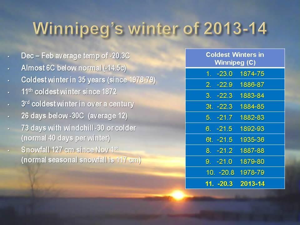
Avg temp ........................ - 9.7C .......... -20.3C
diff from normal .................. + 4.8C ......... - 5.8C
rank out of 141 years...... 4th warmest ..... 11th coldest
rank out of 141 years...... 4th warmest ..... 11th coldest
# of days above normal ........ 70 ........... 18
# of days below normal ........ 18 ............ 66
# of days > 10C below normal 1 ............. 25
# of -20C days .................... 24 ............ 75 (4th most in 141 winters)
# of -20C days .................... 24 ............ 75 (4th most in 141 winters)
# of -25C days .................... 8 ............ 55
# of -30C days .................... 0 ............. 27
One can see how this winter has been a complete flip from the winter of 2011-12. This winter is over 10C colder than 2 years ago, with 3.5 times the number of below normal days. The winter of 2011-12 was the 4th warmest on record in Winnipeg since 1872. This winter has been the 11th coldest, and the 3rd coldest in the last 120 years. Whereas we've seen almost a month's worth of -30C days this winter, there were NONE during the entire winter of 2011-12. Incredibly, there were only 8 days when the temperature went below -25C in 2011-12.. compared to 55 such days this winter. During the winter of 2011-12, there was only 1 day that was abnormally cold (>10C below normal). This winter, we've had 25 such days! It's like we moved 1000 km north this year! What happened?
One can see how this winter has been a complete flip from the winter of 2011-12. This winter is over 10C colder than 2 years ago, with 3.5 times the number of below normal days. The winter of 2011-12 was the 4th warmest on record in Winnipeg since 1872. This winter has been the 11th coldest, and the 3rd coldest in the last 120 years. Whereas we've seen almost a month's worth of -30C days this winter, there were NONE during the entire winter of 2011-12. Incredibly, there were only 8 days when the temperature went below -25C in 2011-12.. compared to 55 such days this winter. During the winter of 2011-12, there was only 1 day that was abnormally cold (>10C below normal). This winter, we've had 25 such days! It's like we moved 1000 km north this year! What happened?
BLAME IT ON THE JET STREAM
Why the dramatic difference between these two winters? The simple answer is due to the jet stream. The jet stream is a strong ribbon of air that flows across the mid latitudes and polar regions across the globe, and separates Arctic air to the north from warmer air to the south. It defines the storm track, along which storms are steered as they travel from west to east across the northern hemisphere. In the winter of 2011-12, the jet stream was quite strong but locked in a westerly orientation across the northern Prairies (see right image below), which effectively blocked intrusions of Arctic air from barrelling southward into the Prairies, while also allowing frequent invasions of mild Pacific air to spread east across southern Manitoba. As a result, temperatures were frequently above normal in this setup, with an average of 7 days above normal for every 2 below. Cold spells were brief and infrequent.
 |
| The behaviour of the jet stream dictates what kind of winter we'll have in southern MB. A wavy jet stream (left) increases likelihood of a colder winter, while a westerly jet stream (right) favours a milder winter with less frequent Arctic outbreaks |
So what dictates how the jet stream will set up? That depends on a number of factors, including large scale climatic oscillations such as the Arctic Oscillation (AO), the North Atlantic Oscillation (NAO), the Pacific Decadal Oscillation (PDO), Madden-Julian Oscillation (MJO) as well as ENSO phases (El Nino, La Nina) The interplay between these oscillations will favour a stronger westerly (aka "zonal") jet stream or a weaker "wavy" jet stream that can vary season to season, and year to year. In addition, some are saying that the rapid melting of the Arctic ice cap is resulting in a weaker jet stream (due to a weaker thermal gradient between the poles and the equator) which would tend to favour a "wavier" jet stream prone to blocking patterns. It's pretty complicated stuff that all depends on global temperatures, winds, ocean currents and ice cover.. so it's easy to understand why it's so difficult to predict what kind of winter we'll have in any given year. Suffice to say, both setups above can result in prolonged periods of abnormally warm or cold weather.. depending on which side of the jet stream you happen to be on. And based on what's been happening over the past few years, it's possible these types of extreme weather patterns may become more frequent in the future, leading to a greater number of abnormally mild or cold winters in the years ahead. Predictability however will continue to be a challenge, until a better understanding of these global interactions is realized. Until then, hope for the good side of the jet stream!
Subscribe to:
Posts (Atom)