 |
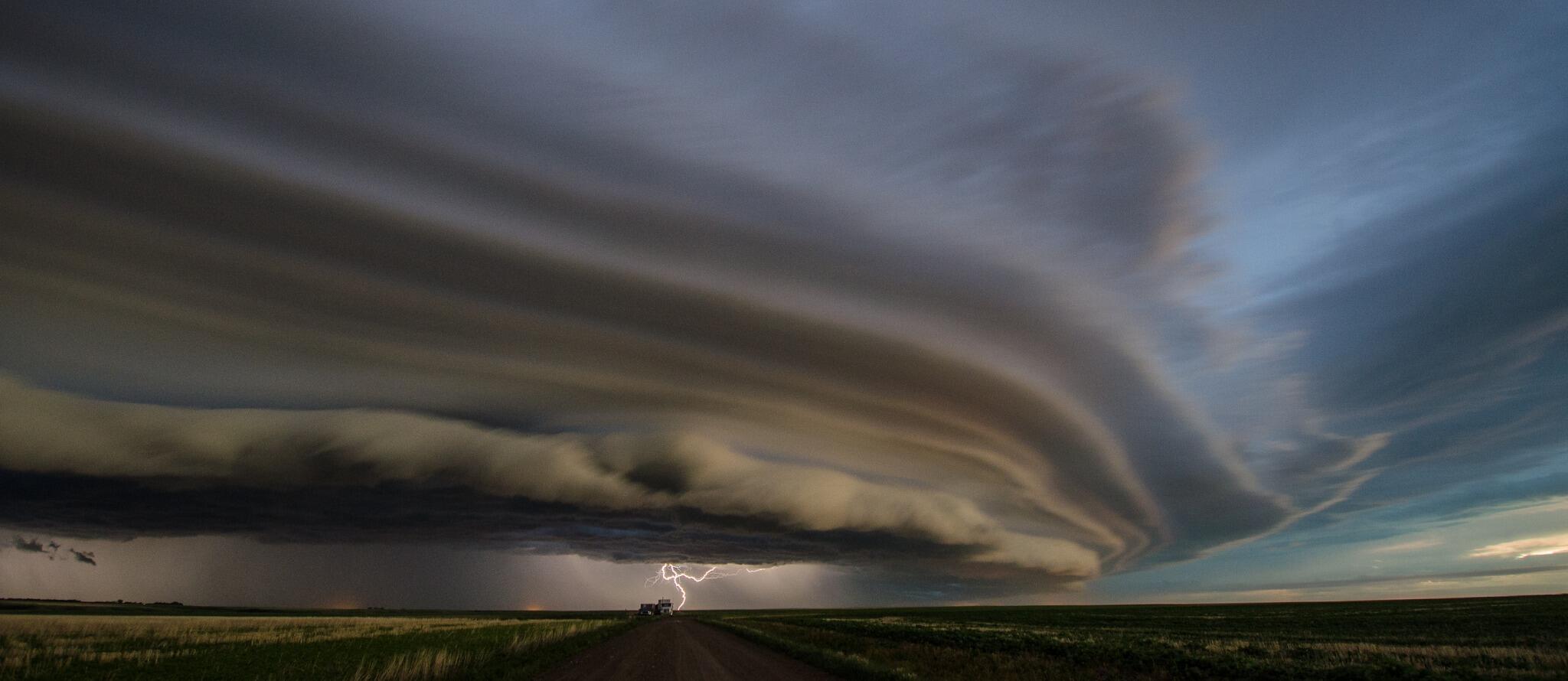
Spectacular image of shelf cloud with thunderstorm
approaching Swift Current SK Monday evening.
Severe thunderstorms possible over SW Manitoba
later today. (image credit @JorBraun) |
It's taken awhile.. but it looks like Winnipeg could be seeing its first 30C reading of the year today as a warm front along the US border lifts north today, tapping very warm and humid air from the south. The increasing humidity will result in humidex values rising to the mid 30s this afternoon.. especially over the southern RRV. By this evening, a trof of low pressure pushing into SE Saskatchewan is expected to trigger some strong to locally severe thunderstorms over SW Manitoba with torrential rain, large hail and strong wind gusts as the primary threats. Isolated tornadoes are also possible with initial strong storms that develop. The thunderstorms are expected to spread into the Interlake and RRV late this evening.. with the potential for heavy rain and strong winds as well as frequent lightning. Welcome to summer!
UPDATE: A high of 30.7C at YWG airport today.. the first 30C reading of the year.
Very humid air mass in Eastern Canada as well.
ReplyDeleteDrummondville, Quebec recorded the highest dewpoint this year in the country at 24.1C.
Ottawa also broke the humidex record for 2013. They had a humidex reading of 42 yesterday.
It will be interesting to see if Southern Manitoba could potentially approach these numbers in the near future.
Rob, if any storms do arrive in Winnipeg tonight, will they mostly likely be discrete storms, or a squall line with a more heighted risk of damaging winds??
ReplyDeleteMore likely a squall line by the time it reaches us.. if at all. Main area of storms expected to track over SW MB into interlake areas mainly west and north of Winnipeg... but certainly possible that storms will grow southward across RRV as line moves across.
ReplyDeleteLooks like we have our first 30c of the year... 29.8C at the airport as of 3 pm but I'm sure they will touch the official 30.0C mark today. A toasty 31C at my place... steamy!
ReplyDeleteVery interesting. One cell moving east over Carlyle SK, and another just popped up near Melita and moving north. Looks like they'll collide west of Virden.
ReplyDeleteSome CBs currently topping 50,000ft in southeast SK, and ND moving into southwest MB.
ReplyDeleteQuite the line of storms heading east/northeast. Would be quite the storm for Winnipeg... except it's Winnipeg so can never rule out the line weakening or fizzling out before hitting.
ReplyDeleteSevere thunderstorm watch expanded a bit eastward including the city. Now, the only question that remains: will the Perimeter Shield strike once again?
ReplyDeleteAlso, question for Rob: as of late, WWCN11 (http://kamala.cod.edu/Canada/latest.wwcn11.CWWG.html) has only been showing just watches, not warnings (at least not the warnings with expiry times). Was the expiry time change involved in it or is there something else at fault?
ReplyDeleteThat question can now be scratched, the warnings are now under WUCN11 (http://kamala.cod.edu/Canada/latest.wucn11.CWWG.html). Thanks to Mike for posting it on his Twitter page!
ReplyDeleteConnor the warnings have been moved to the Wucn11 of CWWG, you might have luck there...
ReplyDeleteAnd have luck I did! Warning now out for the city.
ReplyDeleteJust a bit warmer than last year 30C in June.
ReplyDeleteSurprised the twitter feed on here wasn't more like a bee hive with the storms last night. Sure was a good show, and somewhat revives the dismal start to our storm season!
ReplyDeleteWell I think with these temperature June will be above noraml.
ReplyDeleteHi,
ReplyDeleteWhere did everyone go? Do people not comment on this blog anymore because comments need to be approved? Usually with storms the blog is going crazy. I know I have not bothered commenting because it might take all day to be approved (no offense to Rob). I wish there was another way as it is not enjoyable the way it is.
thanks
Jeff..
ReplyDeleteI hear ya.. and yes, it's not the most ideal setup, but I simply can't let comments go unmoderated.. too many idiots out there that take too much of my time to clean up after.
I think it's also been a combination of lack-luster weather and less frequent updates by myself (crazy month for me.. not enough time as I'd like to keep up with the blog) which may also explain the lack of comments lately.
I may also look into another blog format that would make it easier to weed out trolls, but still allow valid comments to be posted immediately without moderation.
Until then.. keep posting! We're still interested in hearing from all of you, even if it's slightly delayed!
Question for whoever can answer it: The Doppler radar, what's the reason behind only updating every 10 minutes (and only being available 6 minutes after the scan)?
ReplyDeleteEric..
ReplyDelete10 minute scans are what we have with Canada's radar system. It's a different radar system than what the US has (NEXRAD) which has higher resolution and more frequent scan updates.
On that topic, why does our media always make a big deal out of saying "and here's our live Doppler image" but they only show the reflectivity, not doppler (velocity)? I don't expect them to show Doppler as it would confuse people, but then don't call it a Doppler image.
ReplyDeleteHi Rob,
ReplyDeleteI see the forecast for the weekend is 28 and sunny each day. Do you think this will happen or is there a chance this will change and it will rain all weekend?
Thanks
Jeff..
ReplyDeleteIt's looking good this weekend. Today's unsettled conditions will gradually clear up this afternoon into tonight... with sunshine and warm temps for the weekend. 26c or so Saturday and 28C Sunday along with light winds. Should be a beauty!
Well looking at the records at the airport June's average will be close to last years average. It was also drier at the airport than last year. June will also probably be above average.
ReplyDeleteRob, looks like some real summerlike heat coming the second half of next week. Do you think those 30+ temps forecast for mid to late week is realistic or unlikely?
ReplyDelete3 mm in Charleswood in the last hour thanks to a downpour. Looks like these downpours like Charleswood this year. Not a drop in St Vital. Rob up to over 140 mm for the month now.
ReplyDeleteAnd that 3 mm fell in less than 5 minutes with a peak intensity of 135 mm/hr. Getting another downpour now.
ReplyDeleteI just hope this turn to hotter and drier weather this weekend isn't something that will stick all summer like it did in 2011 and 2012. Both those years saw a big turn on the 3rd to 4th week of June and remained relatively locked in heat and dryness through July and August. Although it's been wet this month in parts of southern Manitoba, drought can set in quickly like we saw in 2011.
ReplyDeleteI dont understand this, tornado warning for some areas north of us, yet when i look at radar and all the parameters (i.e. CAPE) at best maybe thundrrstorm. Strange weather we are having.
ReplyDeleteXWG (airport auto) received 6.4 mm between 4-5pm. Ness Ave. was a river as it fell mostly within a 5-10 min period.
ReplyDeleteYes John June's average temperatures will be similar to last year but the precipitation is different because the airport is missing some data.
ReplyDeleteRob do you happen to know what was the rain amount at the airport on the 26th? Looks like another missing data day... Is there somewhere that the public can see this missing data because I don't want to have to keep asking you for the data everytime something is missing.
ReplyDeleteThank you very much
I've checked high and low all across the internet to find that missing data Rob, and I just can't find it. I have found that many sites use the A CS station when the data is missing at the AWOS station. However, I'd like the data from the AWOS station since it's the official station for Winnipeg as a whole.
ReplyDeleteRuth..
ReplyDeleteAccording to the Winnipeg AWOS syno report for the 26th, the precip value is indeed missing for that day (don't know why) so I can't give you an actual reading for the AWOS site that day. The colocated CS station recorded 6.6 mm that day which would have to suffice as a suitable substitute reading. If I find anything more, I'll let you know.
Brendon...
ReplyDeleteThat tornado watch was issued for the potential for what are known as "cold core funnels", which are funnel clouds that can form in low energy environments and can sometimes touch down as weak, short lived, low end tornadoes. They are not the same as funnel clouds associated with high energy supercell environments that can evolve into more violent and longer lived tornadoes that are capable of much more damage and injury.
Rob, do you think temps next Thursday and Friday will actually reach the mid thirties as predicted here in the Winnipeg and much of Southern MB?
ReplyDeleteAnonymous..
ReplyDeleteCurrent model guidance does support temps in the low to mid 30s over southern MB Thursday and Friday.. as 850 mb temps rise into the 20-23C range which would support highs around 32-35C. There are hints of a front passing though Friday which may cut into the highs that day with slightly cooler conditions for the weekend.. but that's still a few days away and timing may change.
But that's still not as toasty as southern Okanagan will be as temps climb to the 40C mark early next week, with some of the traditionally hotter spots like Lytton, Ashcroft, Lilloet, and Osoyoos likely hitting 40-43C by Monday or Tuesday!
Wow. CBC sure changed their forecast. Now only 22C for tomorrow, and in the low to mid 20's all next week!
ReplyDeleteMust...restrain...further...comment.
Rob, what does the thunderstorm potential look like this week for Winnipeg and Southern MB? any severe weather possible or it will be mainly stable for the next 10 days or so?
ReplyDelete>> Anonymous said...Wow. CBC sure changed their forecast. Now only 22C for tomorrow, and in the low to mid 20's all next week!
ReplyDeleteYeah, I noticed that too. Very odd. It's like they're forecasting for a different week. CTV's 7 day forecast graphic looks more reasonable.
>> Anonymous said...Rob, what does the thunderstorm potential look like this week for Winnipeg and Southern MB? any severe weather possible or it will be mainly stable for the next 10 days or so?
ReplyDeleteLooks dry and warm this week through Thursday.. then perhaps a weak cold front will trigger some scattered showers or thunderstorms Friday. Overall though, doesn't look like a good overall pattern for thunderstorms as we get a massive upper ridge building to our west, and we get a predominantly NW upper flow over us which generally is a drier and more stable flow. Which is OK by me.. I need to dry out!
Just hoping it isn't a turn to a prolonged hot and dry pattern like what happened in 2011 and 2012. I do not want another drought year. Although some parts of southern Manitoba had a wet June, some localized areas missed out on the heavy rains, such as the east end.
ReplyDelete