Saturday, September 29, 2012
Stellar weekend to wrap up September..
It will be a beautiful weekend to wrap up September with mainly sunny skies and warm temperatures. Today will be a spectacular fall day with a southerly breeze and clear blue skies allowing temperatures to soar into the upper 20s this afternoon across the Red River valley, with highs of 27C expected in Winnipeg. A great day to enjoy the fall colours. Sunday will see a continuation of the warm weather, although it will be a few degrees cooler as a frontal trough crosses the Red River valley by midday, with some patchy clouds and winds shifting into the northwest. Still, temperatures in the low 20s are expected to close out the month. Enjoy the warm weather while it lasts however because this may be the last mid 20 temperatures we see this season. Significantly colder weather is expected by mid week with high temperatures only in the single digits expected by Wednesday or Thursday.
Monday, September 24, 2012
Dry finish to a dry month.. 2nd driest September on record possible
September 2012 will be ending on a sunny and dry note over the Red River valley and southern Manitoba.. a fitting end to what has been an exceptionally dry month. As of today, only 4 mm of rain has fallen at Winnipeg airport this month, with no precipitation forecast all this week through the end of the month. If so, September will end up as the 2nd driest September on record in Winnipeg since records began 140 years ago in 1872. Only September 1948 will have been drier in the city at 1.3 mm for the month.
Top 5 driest Septembers on record (Winnipeg) - since 1872
1. 1948 ..... 1.3 mm
2. 2012 ..... 4.0 mm (through the 24th)
3. 1938 ..... 6.1 mm
4. 1897 ..... 8.6 mm
5. 1976 ..... 9.9 mm
Normal September rainfall is around 52 mm, so this month's rainfall has been less than 10% of normal. The last appreciable rainfall in Winnipeg was back on August 15th when 9 mm was recorded. Since then, only about 5 mm of rain has fallen in the past 6 weeks, coming off a dry summer that saw a little more than half our normal summer rainfall. This is resulting in very low soil moisture levels, with cracking and shifting clay causing problems with city watermains and house foundations. The dry soil conditions will also become an increasing concern for agriculture and forestry interests if adequate moisture is not received over the winter months. Why has it been so dry? Simply put, the jet stream has been steering storm systems away from the southern Prairies over the past month, with storms systems tracking mainly across northern regions. This has been mainly due to a persistent upper ridge over western Canada that has effectively blocked moisture laden systems off the Pacific from tracking across the southern Prairies (see image of rainfall over past 30 days across Prairies) A pattern change will be needed in October to bring some precipitation bearing systems across southern Manitoba, but past history suggests that may not happen. Of the top 5 driest Septembers in Winnipeg, all but one were followed by much drier than normal Octobers.
Top 5 driest Septembers on record (Winnipeg) - since 1872
1. 1948 ..... 1.3 mm
2. 2012 ..... 4.0 mm (through the 24th)
3. 1938 ..... 6.1 mm
4. 1897 ..... 8.6 mm
5. 1976 ..... 9.9 mm
 |
| Rainfall past 30 days across Prairies. Note large area with little or no rain over the past month. |
Sunday, September 23, 2012
Record cold September morning across RRV and southern MB..
 |
| 7 am temperatures across southern MB Sept 23 2012 |
Record lows across southern MB today..
Site ..................................... New record ....... Old record.... Year .... Records began
Brandon airport        -6.7     -6.7(tie) 1976    1890
Fisher Branch          -8.5     -5.5      2001    1977
Gretna                 -6.3     -2.8      1995    1955
Pilot Mound            -5.0     -5.2      1976    1938
Pinawa                 -4.3     -2.5      1989    1964
Sprague                -6.9     -6.0      1989    1915
Winnipeg               -7.1     -6.1      1879    1872
It will be a nice turnaround today though as sunny skies and light southwest winds send temperatures back into the mid teens this afternoon. Normal highs for this time of year are 16C, with normal lows of +4C.
Thursday, September 20, 2012
Cold front Friday to usher in cooler airmass for first weekend of fall..
Things have cooled off over southern Manitoba this week as a northwest flow of cool air persists over the eastern Prairies. And things will get even cooler Friday into Saturday as a cold front pushes in from the north, ushering in the coolest airmass of the season so far, just in time for the first day of fall Saturday. The cold front is expected to push through Winnipeg from the north around midday Friday, accompanied by a few showers. Behind the front, northerly winds will increase gusting to 60 km/h, ushering in cooler air from the north with temperatures dropping into the single digits. In addition, the cool air over the 15C lake waters will generate bands of lake effect showers off Lake Winnipeg, and Lake Manitoba. Below normal temperatures are expected into the weekend before a gradual warming trend next week.
Monday, September 17, 2012
Dry spell continues.. only 2 mm of rain in Winnipeg since mid August
 |
| Rainfall over past 30 days across Prairies. Note large area with little or no rain from southern AB to southern MB |
 |
| Rainfall in Winnipeg over past 30 days. Moisture deficits are running over 50 mm now. |
Friday, September 14, 2012
2012 growing season ends with frost over much of southern MB..
 |
| 7 am temperatures - southern MB Sept 14 2012 |
And although frost was fairly widespread over the RRV this morning, downtown Winnipeg escaped frost with a low of only +5.0C at the Forks. Downtown Winnipeg has a much longer growing season than the airport, due to the urban heat island effect that keeps night time temperatures warmer than areas near and outside the perimeter. The average first fall frost downtown is Oct 5th, while the last spring frost is May 4th giving an average growing season of 159 days downtown, or 38 days longer than the airport (121 days). For most areas of the city, the length of the growing season lies somewhere between downtown and airport values. At my site in Charleswood, a low of +0.1C was recorded with some light frost.
Wednesday, September 12, 2012
Warmer weather for end of week before cooldown Sunday into next week
After some windy and seasonably cool weather, temperatures will be on the upswing again for Friday and Saturday over southern Manitoba as southerly winds spread warmer air back into the area. Temperatures in the teens Thursday will warm into the mid 20s Friday and upper 20s Saturday as brisk southerly winds develop. That however will be the last of warm weather for awhile as a cold front pushes through on Sunday, bringing significantly cooler air into southern MB for Sunday through much of next week. High temperatures next week will only be in the low to mid teens, along with a possibility of some morning frost depending on cloud cover and wind conditions.
Some scattered showers may accompany the cooler weather next week as well, but overall there doesn't appear to be much in the way of significant rainfall over the next week or so. Things are becoming quite dry over southern MB with only 2 mm of rain in Winnipeg over the past 4 weeks, following a much drier than normal summer, the 10th driest on record in Winnipeg.
Some scattered showers may accompany the cooler weather next week as well, but overall there doesn't appear to be much in the way of significant rainfall over the next week or so. Things are becoming quite dry over southern MB with only 2 mm of rain in Winnipeg over the past 4 weeks, following a much drier than normal summer, the 10th driest on record in Winnipeg.
Saturday, September 08, 2012
Blustery Saturday to give way to pleasant Sunday
It was a blustery start to the weekend over the Red River valley with strong northerly winds gusting over 70 km/h at times along with mainly cloudy skies and temperatures in the upper teens (a peak gust of 80 km/h recorded at the Brady landfill weather station) The winds were associated with a strong push of cool air from northern Manitoba flooding southward. Winds will be diminishing this evening becoming light overnight along with clearing skies that will allow temperatures to drop into the single digits over much of southern MB, including Winnipeg where a low of +4C is forecast. After a chilly start, Sunday will be a much more pleasant day with bright sunny skies, lighter winds and afternoon temperatures rebounding into the low 20s. Conditions will be even warmer Monday as gusty south winds to 50 km/h push in a warm airmass with temperatures rising into the upper 20s along with sunny skies.
Monday, September 03, 2012
Cooling off this week as kids head back to school
The traditional last weekend of summer ended up on a sunny and warm note over Winnipeg with temperatures rising to 29C for Labour Day Monday .. some 8C above normal for early September. But the summerlike temperatures will be on their way out this week as a large storm system over the northern Prairies pushes cooler air towards southern Manitoba over the next few days. Tuesday will see a mix of sun and cloud with highs of 24C, about 5C cooler than today but still seasonably warm for early September. Tuesday night, a cold front will track across southern Manitoba bringing a chance of showers, along with a push of cooler air for Wednesday and the rest of the week. Temperatures will be noticeably cooler as the kids head back to school, with autumn like highs in the upper teens to near 20C through Friday. Sunny and warmer conditions are forecast for the upcoming weekend.
Saturday, September 01, 2012
Showers/thunderstorms possible tonight.. clearing and warmer for remainder of holiday weekend. Cooler conditions for back to school..
A warm front along the international border will push northward across southern Manitoba tonight bringing a threat of showers and thunderstorms, mainly across the south this evening pushing into the Interlake areas overnight. This activity will move into northern Manitoba and northwest Ontario Sunday morning, with a clearing trend over southern Manitoba. This will allow temperatures to rise to the 30C mark once again over the Red River valley with sunshine and a southwest breeze. Sunny and warm conditions are expected to continue into holiday Monday with temperatures again near the 30C mark. Cooler conditions are forecast for the remainder of the week as an upper trof pushes across the Prairies, with temperatures more typical for early September (highs near 21c) along with partly cloudy skies and a threat of showers by mid week.
Warm end to August continues above normal streak.. summer of 2012 ends up as 10th warmest/driest on record in Winnipeg
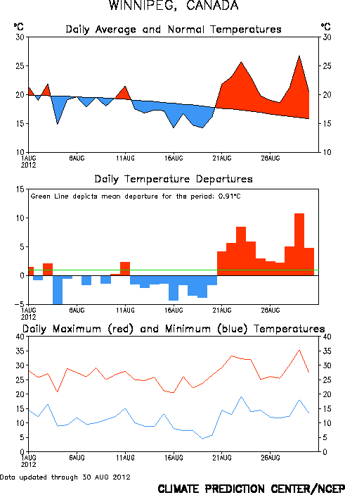 |
| Daily temperature summary for Winnipeg - August 2012 |
As a whole, the summer of 2012 finished with an average temperature of 19.8C for the 3 month period of June, July and August, about 1.5C above normal. This makes the summer of 2012 the 10th warmest on record in Winnipeg, tied with 4 other summers (1919, 1921, 1936 and 2006) Records for Winnipeg started 140 years ago in 1872.
Top 10 warmest summers in Winnipeg (since 1872)
1. 1988 ....... 21.0C
2. 1983 ....... 20.6C
3. 1961 ....... 20.4C
4. 1955 ....... 20.2C
5. 1930 ....... 20.1C
5. 1963 ....... 20.1C
7. 1933 ....... 19.9C
7. 1995 ....... 19.9C
7. 1991 ....... 19.9C
10. 1919 ....... 19.8C
10. 1921 ....... 19.8C
10. 1936 ....... 19.8C
10. 2006 ....... 19.8C
10. 2012 ....... 19.8C
Normal summer average ... 18.4C (1981-2010 average)
 |
| Summer rainfall in Winnipeg June-August 2012. A wet start to the summer turned dry by late June |
Top 10 driest summers in Winnipeg (since 1872)
1. 1929 ......... 76.7 mm
2. 1886 ......... 77.2 mm
3. 1961 ......... 91.0 mm
4. 2006 ......... 91.5 mm
5. 2011 ......... 93.0 mm
6. 1889 ......... 96.0 mm
7. 1894 ......... 97.1 mm
8. 1915 ......... 114.8 mm
9. 1936 ......... 121.4 mm
10. 2012 ......... 129.5 mm
Normal summer rainfall .... 247.5 mm (1981-2010 average)
For additional data and analysis of the warmth this year, consult "A Weather Moment" website.
Subscribe to:
Posts (Atom)