 |
| 24 hr precip amounts in mm to noon Saturday (add 50% for snowfall amounts in cm) |
Friday, November 28, 2014
5-10 cm of snow on the way for Winnipeg
Tuesday, November 25, 2014
Ready or not.. here comes some mid winter cold..
 |
| NAM model showing surface temperatures (F) Wed morning. Arctic high building in from Saskatchewan will bring in mid winter cold over southern MB |
For tonight, a weak clipper system that has been bringing some light snow across southern MB today will exit the province, with gradually clearing skies tonight from the north. This will allow temperatures to drop well into the minus 20s by Wednesday morning, with some spots in the northern Interlake likely hitting the -30C mark (Moosehorn, Grand Rapids, Berens River, Swan River, etc) In Winnipeg, temperatures are forecast to drop to -26C overnight with light northwest winds creating wind chills near -35 for the morning commute. Temperatures will recover only to around -18C Wednesday under sunny skies, some 13C below normal for late November. Wednesday night into early Thursday will be downright frigid in Winnipeg and the RRV as the core of Arctic ridge crosses the region. That will allow temperatures to plummet towards the -30C mark even in Winnipeg Wednesday night into early Thursday morning.. so make sure you have those block heater cords ready and working! (For the record, the earliest that Winnipeg has hit -30C or lower was on November 19th in 1896 with a reading of -33.9C. Record low for Thursday (Nov 27th) in Winnipeg is -36.1C in 1891, and more recently in Nov 1985, the airport had 5 days of -30C or lower over the last week of November. So believe it or not, it has been worse at this time of year)
A slight moderation is expected by Friday as the next clipper system moves in with some light snow, and high temperatures near minus 10C. Unfortunately, it looks like we're back into the deep freeze over the weekend into early next week behind the clipper system. There are some signs that the abnormally cold pattern will relax a bit by the middle to end of next week, but we'll have to see if those moderating signs continue over the next few days. Until then, bundle up and get prepared for some mid winter cold.. in November!
Friday, November 21, 2014
Mild weekend ahead.. but turning snowy and colder Sunday night. Tricky Monday morning commute likely..
After 2 weeks of well below normal temperatures, southern MB will be getting a brief break this weekend with some milder temperatures as a couple of weather systems track across the central Prairies drawing milder air across the south. Southwest winds ahead of the first system today have pushed temperatures well above freezing over snow-free SW Manitoba with Brandon up to +7C this afternoon and +9C in Pierson. A brisk southerly wind over the snow covered Red River valley was keeping temperatures slightly colder in Winnipeg at -2C this afternoon. For Saturday, a weak ridge of high pressure will cross southern MB giving dry weather and light winds, with temperatures above freezing. By Sunday, a storm system will track across southern MB bringing snow through the Interlake and western MB parklands with 10-15 cm possible by Sunday night. As this system tracks east of the RRV later Sunday, winds will shift into the north and draw colder air into Winnipeg and the Red River valley with snow developing. Snow will continue Sunday night into early Monday along with gusty north winds producing local blowing and drifting snow. It's possible we may see 5-10 cm of snow by the Monday morning commute in Winnipeg although there is still considerable uncertainty on snowfall amounts at this point. Regardless, residents should plan for a slow commute to work or school Monday morning due to sharply colder temperatures, gusty north winds giving local blowing and drifting snow, and slippery road conditions.
Friday, November 14, 2014
Manitoba lakes freezing up quickly
 |
| MODIS satellite image of MB lakes Saturday Nov 8 2014 |
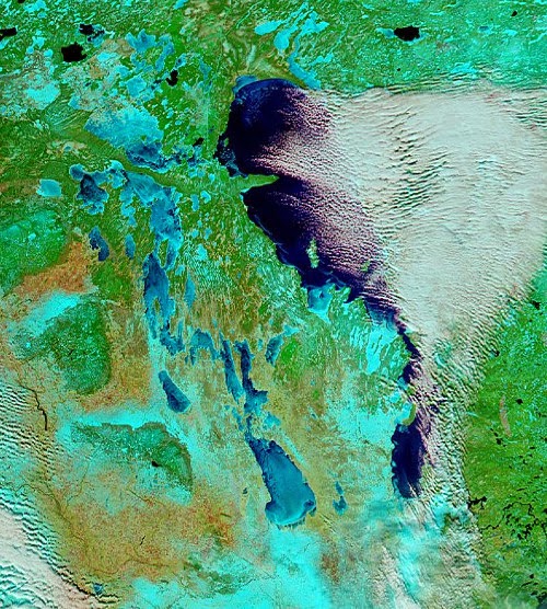 |
| MODIS satellite image of MB lakes Thursday Nov 13 2014 |
Well below freezing temperatures over the past week has brought the first snows of the season over much of southern MB as well as a rapid freeze up of the Manitoba lakes. The two "false colour" MODIS satellite images above were taken just five days apart between Nov 8th (left) and Nov 13th (right) The images show a much different landscape over southern MB over that time with more extensive snow cover (shown in light blue) and a rapid freeze up of the western MB lakes, with Lake Manitoba and Lake Winnipegosis now mainly ice covered. Lake Winnipeg still remains generally ice free except along the shores and some bays.. which is allowing lake effect cloud and flurries to persist as cold winds blow over the open water (open water seen as dark blue on satellite imagery with clouds seen in white) In fact, you can see the bands of heavier lake effect snow over the past day or two immediately south of Lake Winnipeg and Lake Manitoba, with less snow cover elsewhere over southern MB (bare land shows up as light brown)
With a continuation of well below freezing weather over the next 5 to 10 days, ice cover will continue to grow rapidly on the lakes, with Lake Winnipeg likely freezing up by the middle to end of next week. This will effectively shut off the lake effect machine for the season, and will also allow invasions of cold air to spread into southern Manitoba unmoderated by the lakes. Like it or not, winter is here folks!
Tuesday, November 11, 2014
Lake enhanced snowbands may make for tricky morning commute
 |
| Snowfall warning issued for areas south of MB lakes |
Thursday, November 06, 2014
Mild pattern coming to an end.. colder weather on the way this weekend through next week
 | ||
| 6-10 day CPC outlook for next week shows massive outbreak of below normal temps over central and eastern NA |
Subscribe to:
Posts (Atom)